
Major M7.4 earthquake hits Chocó, Colombia, leaving 329 dead and 234 missing
A major earthquake registered by the USGS as M7.4 hit Chocó, Colombia, at 12:34 UTC on August 10, 2026. The agency is reporting a depth of 107 km (66 miles). EMSC is reporting M7.2 at a depth of 95 km (59 miles). According to the Pacific Tsunami Warning Center (PTWC), there is no tsunami threat because the earthquake occurred too deep inside the Earth.
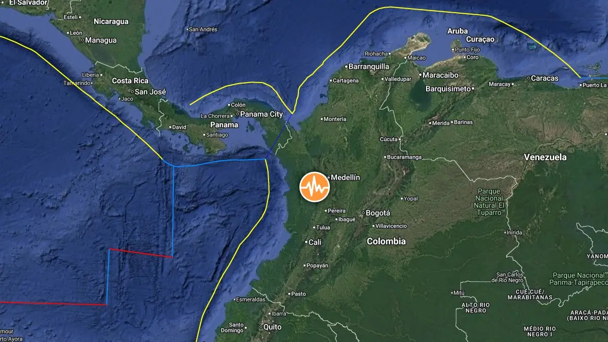
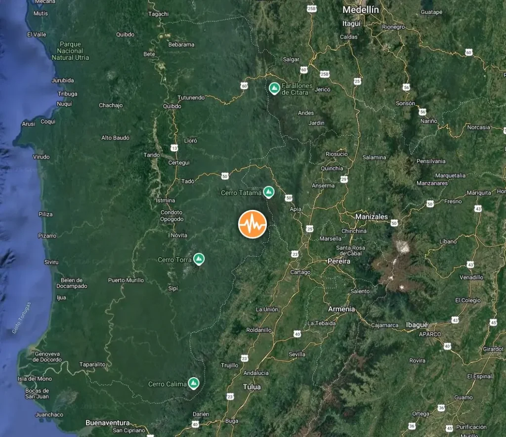
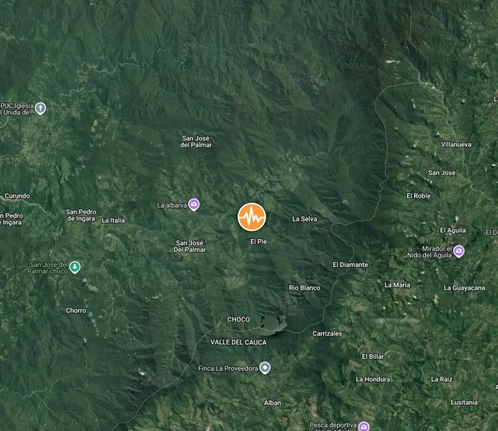
Epicenter of M7.4 earthquake in San José del Palmar, Colombia on August 10, 2026. Credit: TW/SAM, Google
The epicenter was located 5.1 km (3.2 miles) E of San José del Palmar (population 2 392), 24.5 km (15.2 miles) WNW of Ansermanuevo (population 12 332), 31 km (19 miles) SW of Santuario (population 11 787), 34 km (21 miles) W of La Virginia (population 25 900), and 55 km (34 miles) W of Pereira (population 467 269), Colombia.
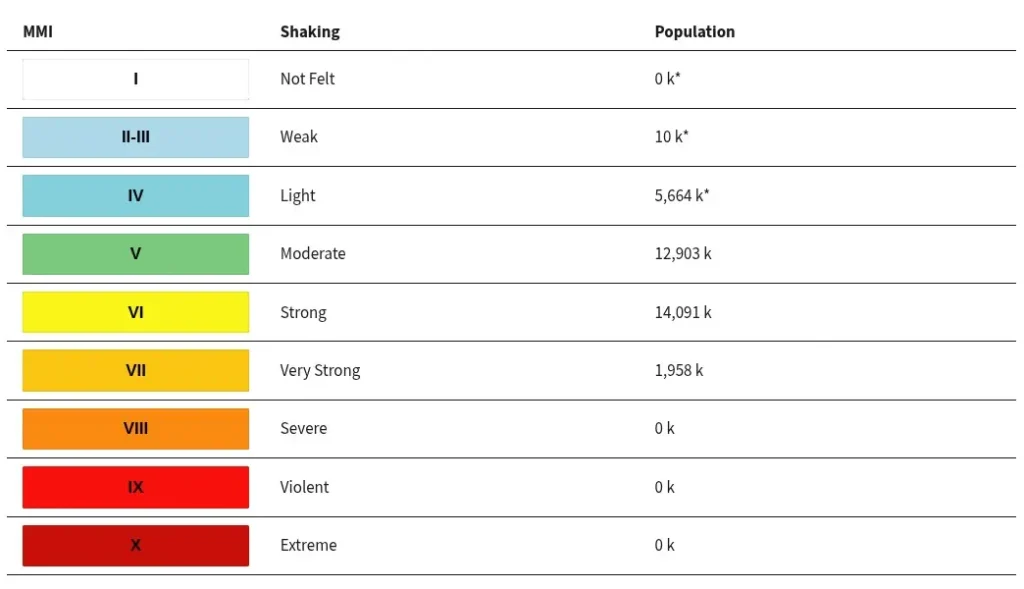
1.9 million people are estimated to have felt very strong shaking, 14 million strong, 12.9 million moderate, and 5.6 million light.
Based on all available data, there is no tsunami threat from this earthquake because it is located too deep inside the Earth, NWS PTWC said at 12:55 UTC. No action is required.
The USGS issued an Orange alert for shaking-related fatalities and economic losses. Significant casualties and damage are likely and the disaster is potentially widespread. Past orange alerts have required a regional or national level response.
Estimated economic losses are less than 1% of GDP of Colombia.
Overall, the population in this region resides in structures that are vulnerable to earthquake shaking, though resistant structures exist. The predominant vulnerable building types are mud wall with wood and unknown/miscellaneous types construction.
Recent earthquakes in this area have caused secondary hazards such as landslides and liquefaction that might have contributed to losses.
Landslides triggered by this earthquake are estimated to have affected a significant area, with a significant population exposed. Liquefaction is estimated to have affected an extensive area, with an extensive population exposed.
Estimated population exposure to earthquake shaking
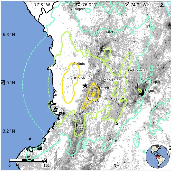
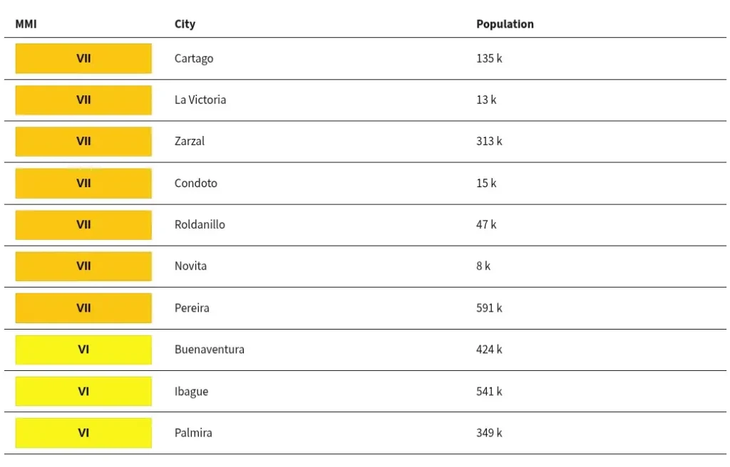
Selected cities exposed
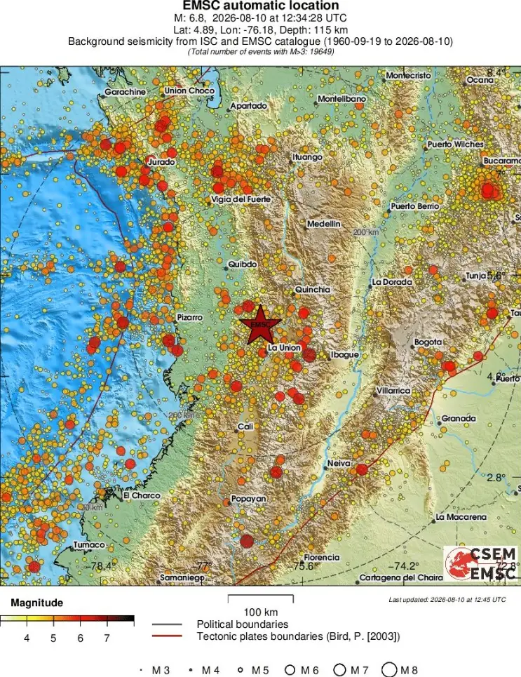
Regional seismicity
Updates
17:38 UTC, August 10
Reuters reported at least 77 deaths at 13:03 UTC, including 42 fatalities in Risaralda reported by Governor Juan Diego Patiño, three deaths in Manizales reported by Mayor Jorge Eduardo Rojas and one death in Buenaventura reported by Mayor Ligia del Carmen Córdoba.
Cali Mayor Alejandro Eder said at least 25 structures collapsed at 12 critical locations in the city, with people trapped under debris. Eder said an elderly woman and a young girl had been rescued alive and that Cali had requested additional disaster-response teams from Bogotá and Medellín.
Damage was reported across several western cities. Reuters reported a building collapse in Pereira, the loss of one of the towers of a cathedral in Manizales, and hospital patients being moved outside in Cali. Chocó Governor Nubia Carolina Córdoba-Curi reported injuries and building damage in Quibdó and warned residents about aftershocks.
Colombia’s civil aviation authority suspended flights at airports in Pereira, Manizales, Quibdó, Armenia, Cartago and Buenaventura while inspectors evaluated possible structural damage. The closures affected six regional airports.
President Abelardo De La Espriella suspended planned activities and traveled to Bogotá to coordinate the government response, according to Reuters. Search-and-rescue operations continued in cities where collapsed buildings and trapped residents had been reported.
A damaging M6.1 earthquake struck roughly 72 km (45 miles) from today’s M7.4 on January 25, 1999, killing at least 1 185 people, according to the USGS historical event record. The earthquake caused severe damage around Armenia and other communities in the region.
06:49 UTC, August 11
Reuters reported at least 164 deaths in its 06:01 UTC update as search-and-rescue operations continued through the night. The report said at least 85 people were killed in Cali, 66 in Pereira and 13 in Chocó, the department closest to the earthquake’s epicenter. Emergency teams, police, soldiers and volunteers continued searching collapsed buildings and flattened homes for survivors.
In Cali, the official Unified Command Post reported approximately 5 000 homes damaged or collapsed, 700 injured, 188 people missing, three hospitals collapsed, 18 other hospitals affected and 39 educational facilities damaged. Authorities said 228 rescuers and search dogs had been deployed to the city, supported by 105 military engineers.
Reuters reported that the upper floors of one Cali hospital partially collapsed, trapping some patients and forcing around 600 others to receive medical care in the street. Rescue workers continued searching unstable and collapsed structures across the city.
President Abelardo De La Espriella declared a national state of emergency, saying the government’s first priority was rescuing people trapped under rubble. Authorities also imposed curfews in Cali and Pereira, while more than 1 000 security personnel were being deployed to Cali following reports of looting.
Cali authorities declared a public calamity and ordered a curfew and additional security measures. The city’s Alfonso Bonilla Aragón airport was operating with restrictions because of earthquake damage.
The death toll is expected to continue rising.
07:02 UTC, August 15
The death toll from the M7.4 earthquake has risen to 288, with 4 018 people injured, 202 missing and 354 rescued, according to the latest balance from Colombia’s National Unit for Disaster Risk Management (UNGRD). The agency reported 145 601 people from 57 516 families affected across 448 municipalities in 15 departments.
UNGRD reported 80 744 homes damaged, 12 504 destroyed and 66 buildings collapsed. Damage assessments also include 2 595 educational facilities, 260 health facilities, 267 roads, 87 aqueducts, 55 bridges and five airports.
Search-and-rescue operations continued four days after the earthquake. Rescuers detected possible signs of life beneath collapsed structures in Cali and Pereira on August 14, and authorities extended search operations through Saturday, August 15. In Pereira, rescuers established contact with a woman calling for help from a collapsed hotel, while authorities in Cali reported indications that at least three people remained trapped beneath damaged buildings.
The Colombian government has begun moving into reconstruction while rescue and humanitarian operations continue. Following a Unified Command Post meeting in Pereira on August 14, President Abelardo De La Espriella said reconstruction of housing, public buildings, schools, hospitals and other earthquake-damaged infrastructure would be incorporated into the government’s Economic Emergency measures and the National Development Plan. The Presidency reported 94 deaths and 259 injuries in Pereira at that reporting point, with 140 000 people from 41 600 families affected in the city.
International financial assistance has also increased. The World Bank disbursed USD 200 million on August 14 to support Colombia’s emergency response and recovery and launched a Global Rapid Assessment of Damages from Earthquakes to estimate physical damage and economic losses.
The United States announced an additional USD 11 million in humanitarian assistance on August 14, bringing total U.S. earthquake assistance to USD 26.5 million, according to the Associated Press. International search-and-rescue teams have also joined Colombian crews. Emergency operations continue.
07:44 UTC, August 27
The death toll from the M7.4 earthquake that struck western Colombia on August 10 has risen to 329, with 234 people still missing, according to the latest situation report from the International Organization for Migration (IOM). The report also lists 364 people rescued and 324 157 people affected.
Fourteen days after the earthquake, Risaralda, Valle del Cauca, Chocó and Caldas remained the priority departments as damage assessments and humanitarian operations continued.
The Colombian government declared a national disaster through Presidential Decree 1171 of 2026 and issued Decree 1261 on August 19, declaring an Economic, Social and Ecological Emergency to support recovery and reconstruction.
Humanitarian flights remain active across the affected region. Patrulla Aérea Civil Colombiana has been transporting doctors, medicines, blood supplies and other critical material to affected cities and isolated communities, including locations where damaged roads and airport infrastructure continue to restrict access.
Civil engineers have also been flown to Pereira and Quibdó to assess damaged buildings, while satellite internet terminals were delivered to communities where electricity and telecommunications remained disrupted, including San José del Palmar.
Canada announced more than CAD 2 million in additional humanitarian assistance on August 26, including funding for food assistance, logistics, emergency shelter, water and sanitation services, and Colombian Red Cross operations.
The UN Central Emergency Response Fund has allocated USD 5 million to the humanitarian response, while the International Federation of Red Cross and Red Crescent Societies’ Disaster Response Emergency Fund allocated CHF 1 million to support Colombian Red Cross operations.
References:
1 M7.4 earthquake 5 km E of San José del Palmar, Colombia – USGS – August 10, 2026
2 M7.2 earthquake Colombia – EMSC – August 10, 2026

Teo Blašković founded The Watchers in 2011 and edited it until 2026, covering seismic and volcanic activity, extreme weather, space weather and near-Earth objects. Articles on this page are his archive.
