
Storm-force winds and high seas forecast over western Atlantic as offshore low rapidly intensifies
Storm-force winds and high seas are forecast over parts of the western Atlantic on Sunday, May 3, 2026, as a rapidly deepening low-pressure system moves northeast off the U.S. East Coast. The NWS Ocean Prediction Center issued storm warnings for offshore waters, with forecast winds reaching 110 km/h (70 mph) and seas building up to 7 m (23 feet).
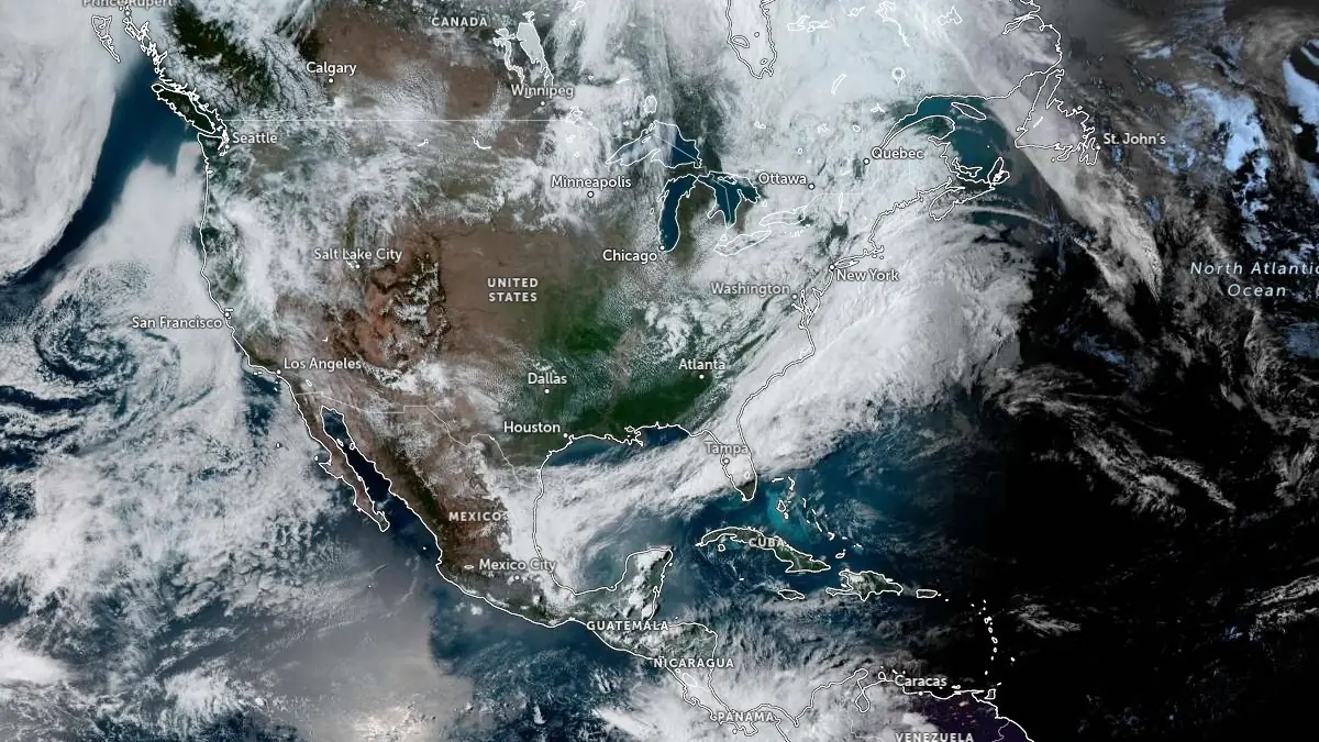
Satellite image acquired at 22:00 UTC on May 2, 2026. Credit: NOAA/GOES, Zoom Earth, The Watchers
The NWS Ocean Prediction Center (OPC) placed the low over the western Atlantic off the U.S. East Coast at 1 004 hPa at 00:00 UTC on Sunday, May 3. The system was moving northeast at 45 km/h (30 mph) and was forecast to deepen to 990 hPa in 12 hours and 980 hPa in 24 hours as it moved farther into the North Atlantic.
“Low pressure just off of the South Carolina coast will gradually intensify as it moves northeast and farther off of the East Coast today,” OPC said early Sunday. “As the low starts to rapidly intensify overnight, by early Sunday morning, areas of storm-force sustained winds are expected well offshore of the New Jersey and southern New England coasts.”
“Wind gusts to hurricane force are likely close to the low pressure center Sunday as the low continues to move northeast toward Nova Scotia. Mariners should monitor forecasts and make preparations now to practice avoidance along and near the track of the low.”
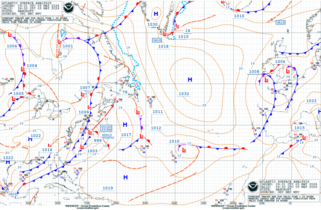
Storm conditions were forecast east of New England, including waters near Georges Bank and Nantucket Shoals, where NAVTEX marine forecasts placed the area under a storm warning. Winds were expected to reach 95 km/h (60 mph), with seas building to 3–5 m (10–16 feet) on Sunday. Surrounding offshore regions remained under gale warnings, with winds generally between 45–85 km/h (30–52 mph) and seas of 2–4.5 m (7–14 feet).
The warning area extended across a broad section of the western Atlantic, from the Mid-Atlantic offshore waters to southern New England. Forecast zones from Hatteras Canyon to waters east of Cape Fear were expected to experience winds up to 55 km/h (35 mph), with seas of 2–3 m (7–10 feet) early in the period. Farther north, offshore waters south of New England were forecast to see winds up to 65 km/h (40 mph), with seas reaching up to 4.5 m (14 feet).
The system is forecast to continue deepening east and northeast of New England through Monday as it moves into the North Atlantic.
The Weather Prediction Center (WPC) said the system would intensify over the Gulf Stream while tracking just offshore of New England. Rain and gusty winds were forecast to affect southeastern New England Saturday night and eastern Maine during the day Sunday. Higher elevations of interior New England could see isolated snow showers.
The system developed as a cold front moved off the southeastern United States and interacted with the Gulf Stream. Although strong extratropical systems are less frequent in early May than during winter, spring transition patterns can support rapid intensification over the western Atlantic.
References:
1 National Weather Service Marine Forecast – NOAA/NDBC – May 3, 2026
2 Short Range Forecast Discussion – NWS/WPC – May 2 and 3, 2026
I'm a dedicated researcher, journalist, and editor at The Watchers. With over 20 years of experience in the media industry, I specialize in hard science news, focusing on extreme weather, seismic and volcanic activity, space weather, and astronomy, including near-Earth objects and planetary defense strategies. You can reach me at teo /at/ watchers.news.
Commenting rules and guidelines
We value the thoughts and opinions of our readers and welcome healthy discussions on our website. In order to maintain a respectful and positive community, we ask that all commenters follow these rules.