
Extreme and Critical fire weather trigger widespread Red Flag Warnings across Plains and Front Range
An outbreak of extremely critical fire weather developed across the central and southern High Plains on February 17, 2026, as a strengthening storm system swept out of the Rockies. The event produced widespread hurricane-force wind gusts, single-digit humidity, and volatile fire behavior potential. The Storm Prediction Center issued its highest-level Extremely Critical Fire Weather Outlook, while multiple National Weather Service offices posted Red Flag Warnings, including Particularly Dangerous Situation designations in several areas.

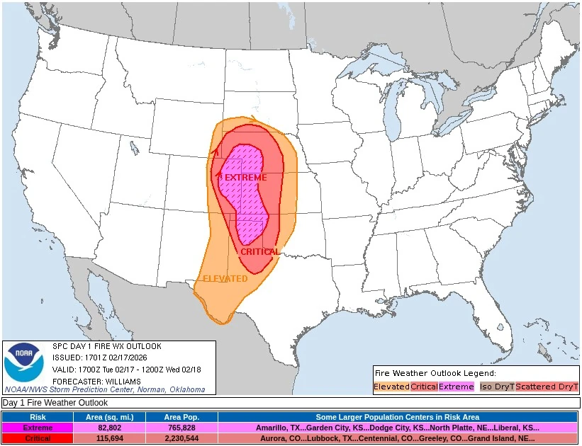
Critical Fire Weather Map for Tuesday February 17, 2026. Credit: NOAA/SPC
Extremely dry air and strong downslope winds combined on Tuesday, February 17, to create one of the most dangerous fire-weather setups of the season across eastern Colorado, southwestern Nebraska, western Kansas, and the Texas and Oklahoma Panhandles.
By midday, Red Flag Warnings covered a corridor more than 1 600 km (1 000 miles) long, stretching from northern New Mexico and the Trans-Pecos through Oklahoma, Kansas, and Nebraska into eastern Colorado and southeast Wyoming. Some warnings carried the rare “Particularly Dangerous Situation” language reserved for exceptionally volatile fire environments.
Wind gusts of 95–110 km/h (60–70 mph) were recorded in exposed areas as relative humidity values dropped below 10%. Temperatures climbed into the lower to upper 20s °C (70s to low 80s °F) under strong compressional warming.
Forecasters described conditions as highly supportive of significant, dangerous wildfire spread, and urged residents to avoid any activities that could generate sparks or flames.
The meteorological setup featured a deep surface trough developing east of the Rocky Mountains beneath a powerful 185–200 km/h (115–125 mph) jet stream aloft. This configuration produced intense downslope flow and deep boundary-layer mixing, transferring strong winds to the surface and sharply reducing humidity.
Poor overnight recoveries left fine fuels, dormant grasses, and surface litter, ready to ignite. The combination of strong pressure gradients, very low humidity, and critically dry vegetation marked the strongest Plains fire-weather pattern so far in 2026.
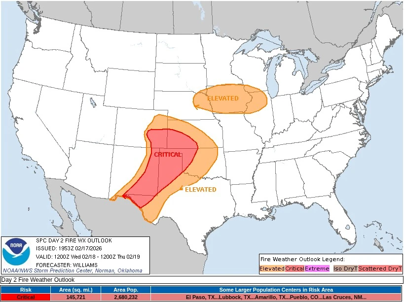
A second day of heightened fire danger is forecast to follow on Wednesday, February 18, and the Storm Prediction Center highlights a large Critical Fire Weather Area across portions of the central and southern High Plains.
A deepening surface low over eastern Colorado and strong mid-level winds ahead of an approaching shortwave trough will sustain another period of dry, windy conditions from eastern New Mexico through the Texas and Oklahoma Panhandles into western Kansas.
Afternoon relative humidity is expected to fall to between 10 and 20%, locally reaching single digits across eastern New Mexico and the southern High Plains, while south- to southwesterly winds of 25–40 km/h (15–25 mph) combine with critically dry fuels to support high-end Critical fire-weather potential.
Model guidance also indicates a modest northward and eastward expansion of the Critical area into parts of Kansas, Oklahoma, and Texas, with elevated conditions likely persisting into the evening hours.
Farther northeast, a belt of dry and breezy weather is also forecast across parts of the Midwest, including eastern Nebraska, Iowa, and northwestern Illinois, beneath the southern flank of a mid-level jet stream. Westerly winds of 25–40 km/h (15–25 mph) and relative humidity near 20% may bring locally elevated fire-weather concerns, though recent scattered rainfall should limit fuel dryness.
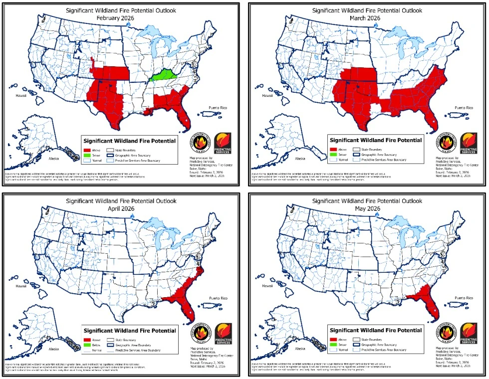
The heightened fire danger aligns with the National Interagency Coordination Center’s February 2, 2026, National Significant Wildland Fire Potential Outlook, which forecasts above-normal significant fire potential across much of the southern and central Plains and the northern Front Range of Colorado during February and March.
Above-normal potential is also forecast across large portions of the Southeast and the northern Gulf Coast. A smaller corridor from Kentucky into western Virginia is designated for below normal significant fire potential in February due to cooler conditions and lingering winter impacts.
Despite regional concerns, national wildfire activity remains seasonally low, and the National Preparedness Level is at 1 on a 1-5 scale.
However, fire occurrence during January exceeded recent historical averages for this time of year. Total acres burned through January 30 reached approximately 148% of the 10-year average, and the number of reported wildfires was about 220% of average.
In Oklahoma, 31 wildfires burned about 6 224 ha (15 384 acres) during January under dry and windy conditions. Most incidents were contained by local and state resources, but the activity highlighted the receptiveness of dormant fine fuels across the southern Plains.
Drought remains a primary factor of elevated fire potential. As of mid-February, approximately 39% of the United States and Puerto Rico were in drought. Moderate to severe drought persists across large portions of Texas, Oklahoma, Arkansas, Louisiana, Mississippi, Alabama, and Georgia.
In parts of the Southeast, rainfall deficits during the past six months range from approximately 125 to 380 mm (5 to 15 inches) below average. Dry grasses and accumulated fine fuels remain highly receptive to ignition when strong winds occur.
A major winter storm from January 23 to 26 affected a corridor about 2 400 km (1 500 miles) long from eastern New Mexico through the Mid-South into the Appalachians. Severe ice accretion in northern Mississippi and central Tennessee caused extensive tree damage and prompted the deployment of five Complex Incident Management Teams. Ice impacts extended west into northeast Texas and northeast into West Virginia.
The storm left widespread downed limbs and accumulated pine needles across the region, substantially increasing surface fuel loads. As conditions dry into spring, this added fine and medium woody debris is expected to enhance fire spread potential where ignitions occur.
Climate conditions are also influencing the seasonal outlook. The El Niño–Southern Oscillation remains in a weak La Niña phase, with sea surface temperatures in the central equatorial Pacific averaging about 0.5°C (0.9°F) below normal. The Climate Prediction Center forecasts a transition to ENSO-neutral conditions during March.
February outlooks favor above normal temperatures across much of the West and below normal temperatures east of the Mississippi River. Precipitation outlooks favor below normal precipitation across portions of the southern Plains and Southeast, supporting continued drought persistence.
The February through May outlook indicates that above normal significant fire potential will expand across much of the Southern Area in March, except for a northern tier from Arkansas to western Virginia and portions of southeast and West Texas and southwest Louisiana that are forecast to remain near normal.
Elevated potential is expected to continue in eastern New Mexico and southeastern Colorado into Kansas during March as winds increase and fuels remain dormant.
By April, above normal significant fire potential is forecast to contract primarily to the Southeast Atlantic coast and Florida. In May, above normal potential is expected to be largely confined to South Georgia and Florida as seasonal green-up reduces fire spread potential across much of the interior southern United States.
Elsewhere, most regions are forecast to experience normal to significant fire potential through early spring. Snowpack in parts of Nevada, Utah, Colorado, and Oregon remains well below normal.
Although this does not immediately elevate late-winter fire potential in those regions, below-normal snowpack may support earlier seasonal drying if spring precipitation is limited.
The current pattern reflects typical late-winter fire climatology across the southern Plains and Southeast, where dormant grasses combined with strong winds can produce rapid fire spread even before peak wildfire season begins.
While national activity remains limited, drought, storm-related debris, and repeated wind events continue to support elevated early-season fire danger across parts of the southern United States.
References:
1 Day 1 Fire Weather Outlook – NWS/SPC – February 17, 2026
2 Day 2 Fire Weather Outlook – NWS/SPC – February 17, 2026
3 Significant Wildland Fire Potential Outlook February to May 2026 – NIFC – February 2, 2026

I’m a science journalist and researcher at The Watchers, contributing to the Epicenter edition, where I cover peer-reviewed scientific research and emerging discoveries across Earth and space sciences. With a background in astronomy and a passion for environmental science, I’ve worked in shark and coral conservation in Fiji, conducting reef and shark-behavior research, contributing to mangrove restoration, and earning PADI Open Water and Coral Reef Certifications. I bring a blend of scientific rigor and storytelling to illuminate the discoveries shaping our planet and beyond.
Commenting rules and guidelines
We value the thoughts and opinions of our readers and welcome healthy discussions on our website. In order to maintain a respectful and positive community, we ask that all commenters follow these rules.