
Strong atmospheric river to impact the US West Coast
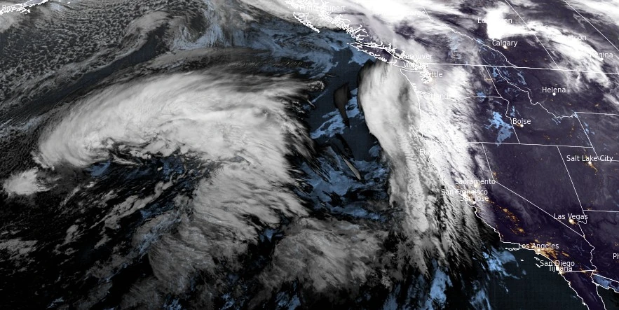
Image credit: NOAA/GOES-West, RAMMB/CIRA, The Watchers
Starting Tuesday night, January 30, 2024, an atmospheric river will affect southern Oregon and northern California, bringing widespread rain, heavy mountain snow, and strong winds, with impacts expanding to central California and continuing through February 2.
A potent atmospheric river is poised to begin impacting southern Oregon and northern California on the night of January 30, 2024, before spreading to central California. This system is expected to deliver widespread low-elevation rain, heavy mountain snow, and gusty to high winds across the region.
NWS forecaster Ziegenfelder noted that on Wednesday, January 31, a more robust plume of moisture will advance over California, preceding a front that moves onshore late Wednesday afternoon into Thursday. This event marks the beginning of an active weather pattern forecasted to continue through Friday, February 2, 2024, as another strong atmospheric river (AR) makes landfall along the US West Coast.
The first AR made landfall late Sunday, January 28, affecting British Columbia and the Pacific Northwest, while the second AR is forecast to make landfall across the US West Coast later on January 30, moving down the coast through February 2. Following the second AR, a ridge is likely to develop over the Northeast Pacific, potentially leading to a temporary cessation of AR conditions for the US West Coast.
While both ARs were anticipated to bring significant precipitation to the region, the heaviest rainfall is expected from the second AR, particularly over Northern California, along with heavy snowfall over the Sierra Nevada mountain range.
The Weather Prediction Center’s Excessive Rainfall Outlook has indicated a Slight Risk (level 2 of 4, or at least a 15% chance) of flash flooding in Northern California for the 24-hour period ending at 04:00 PST on Thursday, February 1, and in Southern California for the same period ending at 04:00 PST on Friday, February 2, associated with the second AR.
Areas most vulnerable to the expected heavy rainfall include urban locales, roads, small streams, and burn scars. Additionally, significant snowfall is forecast for the Shasta and Sierra Nevada mountains, commencing late Wednesday morning and continuing into Thursday.
Rivers across the Pacific Northwest have risen due to the AR that made landfall on Sunday. The NWRFC is currently reading 13 stream gages in the bankfull stage and four stream gages in the minor flood stage along the WA and OR coasts.
River stages in CA are forecast to rise as a result of the precipitation associated second AR. CNRFC is currently forecasting 12 gages to exceed the monitor stage and 5 gages to exceed the flood stage in the next 5 days.
The Russian River at Hopland guidance shows the river reaching flood level on January 31. The river stage at this location is forecast to rise 4.6 m (15 feet) through January 31. Meanwhile, the San Diego River at Fashion Valley guidance shows the river reaching flood level on February 1 as the second AR moves down the coast, bringing heavy precipitation to Southern California.
References:
1 Atmospheric River Outlook – CW3E – January 29, 2024
2 Short Range Forecast Discussion – NWS Weather Prediction Center College Park MD – 233 AM EST Tue Jan 30 2024
I'm a dedicated researcher, journalist, and editor at The Watchers. With over 20 years of experience in the media industry, I specialize in hard science news, focusing on extreme weather, seismic and volcanic activity, space weather, and astronomy, including near-Earth objects and planetary defense strategies. You can reach me at teo /at/ watchers.news.
Commenting rules and guidelines
We value the thoughts and opinions of our readers and welcome healthy discussions on our website. In order to maintain a respectful and positive community, we ask that all commenters follow these rules.