
Storms on the horizon for California
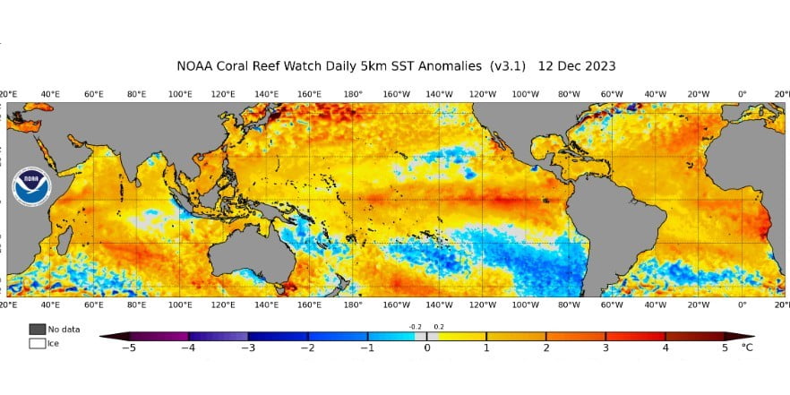
Image credit: NOAA
As the week before Christmas approaches, California is gearing up for a possible shift in weather patterns, with indications of a wetter regime on the horizon. AccuWeather senior meteorologist Alex Sosnowski notes that the extent of the storminess will hinge on El Niño’s influence and other climatic factors in the coming weeks.
The state, typically seeing its first winter rains in late October, has experienced a dry start to the season, as pointed out by AccuWeather Chief On-Air Meteorologist Bernie Rayno. This contrasts starkly with last winter, when early November storms brought significant rainfall to areas like San Francisco and Los Angeles. While this season’s wet onset is delayed, meteorologists expect it to pick up later in December, albeit possibly not matching the previous winter’s intensity.
Forecasts suggest a system bringing clouds, low-elevation rain showers, and mountain snow to Northern and Central California soon. This is likely to be followed by a more potent storm early next week, potentially bringing significant rain to Northern and Central California and even some parts of Southern California’s coast. The storm’s progression could lower freezing levels over the Cascades and the northern Sierra Nevada, leading to snowfall down to pass levels.
El Niño, characterized by a stream of warm water in the eastern subtropical Pacific, is a key factor behind the expected stormy winter. Current water temperatures in this region are around 1.5 °C (2.7 °F) above average, creating conditions conducive to an active southern jet stream and storm track. This El Niño pattern has been delivering rain to Southeast states and could soon redirect its effects to California.
However, the presence of cooler-than-average waters southeast of Hawaii might alter this trajectory, potentially steering the storm track more toward Mexico and the Gulf of Mexico. If these cooler waters warm up, the storm track could shift to a more typical strong El Niño pattern over Southern California and the southern United States.
California’s weather change is expected to be gradual, with chances of rain and mountain snow in the second half of December. However, the intensity of this pattern could escalate in the ensuing weeks and months, influenced by El Niño and surrounding sea surface temperatures in the Pacific.
References:
1 Incoming California storms linked to strong El Niño in Pacific – AccuWeather – December 14, 2023
The Watchers team and our contributors bring the latest on extreme weather, earthquakes, volcanic eruptions, space weather, and all things science. We're all about making sense of the natural world and keeping you informed on what’s happening. Got a tip or a question? Hit us up using the form at newstips!
Commenting rules and guidelines
We value the thoughts and opinions of our readers and welcome healthy discussions on our website. In order to maintain a respectful and positive community, we ask that all commenters follow these rules.