
Widespread hazardous weather to impact the Central U.S.
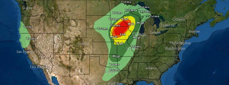
Image credit: NWS
A rapidly strengthening storm system will shift from the central Rockies to the upper Great Lakes today with widespread high winds, exceeding 110 km/h (70 mph) in some locations. Wind damage and power outages are likely with difficult to dangerous travel conditions.
A developing area of low pressure over the Central Plains will move northeastward to the Upper Great Lakes by late Wednesday night, December 15, 2021, then move into Central Ontario by Thursday, December 16, producing a myriad of weather and associated hazards, NWS forecaster Ziegenfelder noted.1
First, the storm will create snow from the Northern Rockies to parts of the Southwest that will move onto the Northern/Central Plains by Wednesday evening.
Next, rain in the Great Lakes will move into the Northeast, with light snow developing over parts of Northern New England.
Then, overnight Wednesday, as the warm air moves in over the region, cold air will get trapped in the valleys and produce areas of freezing rain over parts of Northern New England through Thursday evening.
Additionally, isolated pockets of freezing rain will develop over parts of the Upper Midwest along the rain-snow line on Wednesday afternoon into the late evening.
Third, the rain over the Upper Great Lakes will begin to become more convective in nature (thunderstorms). During the afternoon, showers and thunderstorms will develop along and ahead of the associated front; some of the thunderstorms will become severe.
Therefore, the Storm Prediction Center (SPC) has issued Moderate Risk of Severe thunderstorms over parts of the Upper/Middle Mississippi Valley through Thursday morning.
The hazards associated with these thunderstorms are frequent lightning, severe thunderstorm wind gusts, hail, and a few tornadoes.
There is a 10% or greater probability of 120 km/h (75 mph) or greater wind gusts over the region.
The thunderstorms will wind down over the Upper Midwest and change over to snow by Thursday.
The fourth hazard will be high wind associated with the strong pressure gradient associated with the deep area of low pressure.
Therefore, high Wind Warnings are posted from the Central/Southern High Plains to the Great Lakes, with Storm Warnings over Lake Michigan.
Furthermore, ahead of the front, temperatures will be 14 – 22 °C (25 – 40 °F) above average for the Plains, Mississippi Valley, and Great Lakes/Ohio Valley.
In addition, many record-high temperatures are forecast over parts of the Southern Plains into the Upper Midwest.
Along with the heat, the SPC has issued an Extreme Fire Weather risk for parts of the Central/Southern Plains through Thursday morning. Very dangerous wildfire-spread conditions will be over the region, with dry fuels and very windy conditions with wind gusts up to 65+ km/h (40+ mph).
Reference:
1 Short Range Forecast Discussion – NWS Weather Prediction Center College Park MD – 328 AM EST Wed Dec 15 2021
The Watchers team and our contributors bring the latest on extreme weather, earthquakes, volcanic eruptions, space weather, and all things science. We're all about making sense of the natural world and keeping you informed on what’s happening. Got a tip or a question? Hit us up using the form at newstips!
Commenting rules and guidelines
We value the thoughts and opinions of our readers and welcome healthy discussions on our website. In order to maintain a respectful and positive community, we ask that all commenters follow these rules.