
Intense cold front affecting South Africa, warnings for disruptive snowfall and severe thunderstorms

Image credit: EUMETSAT. Acquired August 26, 2021
An intense cold front associated with a steep upper-air trough is affecting parts of South Africa since Thursday, August 26, 2021. The front is spreading eastwards, bringing heavy rains, disruptive snow, and cold temperatures. A change in weather conditions is expected from Monday, August 30.
- A Yellow level 4 Warning for Disruptive snowfall is in effect for parts of KwaZulu-Natal on Saturday, August 28. Impacts expected include loss of vulnerable livestock, closure of mountain passes and temporary closures of roads, major traffic disruptions, and temporarily cut-off communities. The warning is valid from 12:00 UTC on August 28 to 01:00 UTC on August 29.
- A Yellow level 4 Warning for Severe thunderstorms is in effect along the escarpment areas of Mpumalanga on Saturday afternoon into the evening. Hail, strong and damaging winds, and heavy downpours are possible. The warning is valid from 12:00 to 23:00 UTC on August 28.
"Cold to very cold temperatures are expected over the central, southern, and western parts of the country from Friday into Saturday (August 27 – 28, 2021). Atmospheric conditions will become ideal for widespread snowfall to occur over the high-lying areas of the Cape provinces during Friday. Snowy conditions will subsequently spread to KwaZulu-Natal and Lesotho on Saturday," the South African Weather Service (SAWS) said.1
SAWS said it expects disruptive snowfalls of 5 to 10 cm (2 – 4 inches) from Friday onwards over the high-lying areas of the Western Cape as well as the western and southern high-lying areas of the Northern Cape.
Heavier snowfall of 10 to 20 cm (4 – 8 inches) is also likely over the extreme south-western parts of the Northern Cape (including the Nuweveld and Roggeveld mountains) as well as the Cederberg and Hex River mountains of the Western Cape.

24-hr snowfall accumulation in cm for August 27 and 28, 2021. Source: High Resolution Unified Model (South African Weather Service)
Due to significant cooling within the atmosphere and corresponding lowering of freezing levels, snow can also be expected at lower altitudes and in the lower foothills of mountain ranges.
Snowy conditions are expected to reach the western and central high-lying areas of the Eastern Cape (Sneeuberge and Winterberg mountains) during Friday evening, while the south-western and western high-lying areas of KwaZulu-Natal and the Drakensberg region can anticipate snowfall by Saturday.
These conditions will persist until Saturday morning over the western and southern parts of the Northern Cape and the high-lying areas of the Western Cape, persisting well into the evening over the high-lying areas of the Eastern Cape and the western and southern high-lying areas of KwaZulu-Natal.
The extreme northeastern Drakensberg mountains of the Eastern Cape and the south-western mountains of KwaZulu-Natal may experience disruptive snowfall during the course of Saturday, which may result in the closure of mountain passes and associated disruption to traffic due to icy and slippery roads. Moreover, some communities at higher altitudes (such as ski lodges) may become isolated due to deep snowdrifts.
Cloudy, cold, and wet weather will persist on Saturday, August 28, 2021, along the south-western, southern and south-eastern coastal regions of the country, extending across the eastern half of the Eastern Cape and most parts of KwaZulu-Natal.
Significant rainfall, in the order of 20 to 40 mm (0.8 – 1.6 inches) may occur over parts of KwaZulu-Natal and the extreme eastern parts of the Eastern Cape on this day. Cold to very cold conditions will dominate the majority of the interior of the country on Saturday and Sunday, with the possible exception of the north-eastern Lowveld areas, where, by contrast, it will be warm to hot on Saturday.
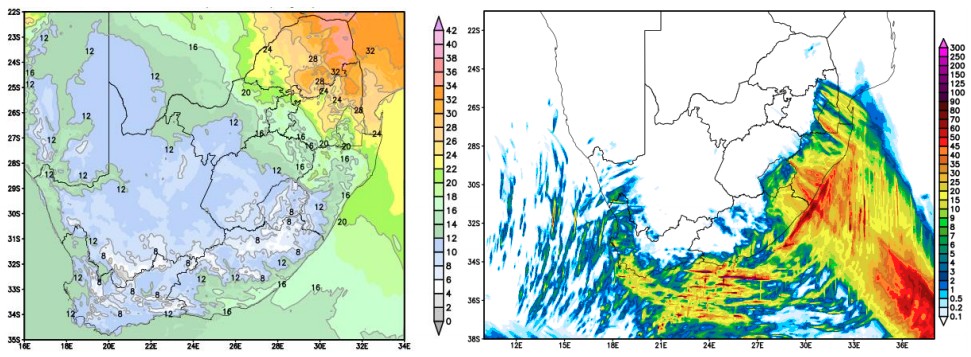
Predicted maximum temperatures (left) and 24-hour rainfall accumulation in mm (right) for August 28, 2021. Source: High Resolution Unified Model (South African Weather Service)
South Africans can expect a gradual clearing in weather conditions, combined with a consistent recovery in daily daytime temperatures from Monday onwards.
Given that overnight minimum temperatures may take several days to recover in the wake of this cold spell, there is a distinct possibility of overnight frost occurring over parts of the interior early next week.
References:
1 SAWS – Media Release August 26, 2021
I'm a dedicated researcher, journalist, and editor at The Watchers. With over 20 years of experience in the media industry, I specialize in hard science news, focusing on extreme weather, seismic and volcanic activity, space weather, and astronomy, including near-Earth objects and planetary defense strategies. You can reach me at teo /at/ watchers.news.
Commenting rules and guidelines
We value the thoughts and opinions of our readers and welcome healthy discussions on our website. In order to maintain a respectful and positive community, we ask that all commenters follow these rules.