
Tornado west of Jena, Louisiana to begin tornado outbreak in U.S.
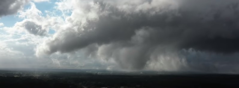
Image credit: Reed Timmer (stillshot)
A tornado was intercepted by Reed Timmer's Dominator Drone just west of Jena, Louisiana at 17:50 LT on May 2, 2021.
A tornado outbreak unfolded after this across Mississippi including a tornado that just passed through the Tupelo, Mississippi area with a tornado emergency.
The outbreak unfolded at the nose of a potent elevated mixed layer.
"Speaking to friends in Tupelo and they say it looks like it hit their downtown office; lots of damage," Timmer said.
Severe thunderstorms and heavy rains may bring damaging gusts, large hail, a few tornadoes, and flash flooding across parts of the Southern Plains into the middle Mississippi and lower Ohio Valleys, NWS warned on May 3.
Severe thunderstorms and flooding in parts of the Central U.S.
"A quasi-stationary front extending from the Northeast to the Upper Midwest, then to the Southwest will move slowly to the Ohio Valley roughly southwestward to the Lower Mississippi Valley by Tuesday evening, May 4," NWS forecaster Ziegenfelder noted.
Additionally, upper-level impulses will move eastward ahead of the boundary in the warm sector, moving to the Mid-Atlantic through Tuesday.
Multiple days of severe thunderstorms and heavy rain will be associated with this system from the Central Plains to the Lower Mississippi Valley into parts of the Ohio Valley and parts of the Southeast through Tuesday.
The SPC has issued an Enhanced risk of severe thunderstorms over parts of the Central Plains and a Slight risk of severe thunderstorms over parts of the Lower Mississippi and Tennessee Valleys through Monday morning.
Over the Central Plains, the main hazards will be frequent lightning, severe thunderstorms wind gusts, hail, and a few tornadoes.
There is a 10% or greater probability of wind gusts up to 120 km/h (75 mph) or greater over parts of the Central Plains.
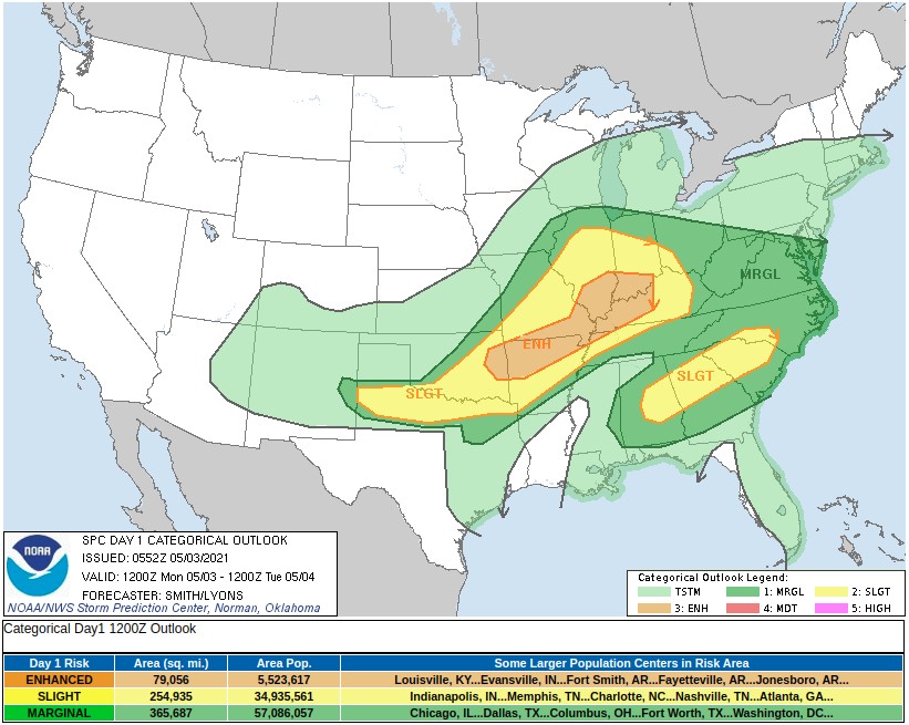
Furthermore, the SPC has issued a Sight Risk of severe thunderstorms over parts of the Lower Mississippi/Tennessee Valleys through Monday morning.
The main hazards associated with severe thunderstorms are frequent lightning, severe thunderstorms wind gusts, hail, and a few tornadoes. Moreover, heavy rain will be associated with severe thunderstorms.
The WPC has issued a Slight risk of excessive rainfall over parts of the Central Plains and the Central Gulf Coast through Monday morning.
The Watchers team and our contributors bring the latest on extreme weather, earthquakes, volcanic eruptions, space weather, and all things science. We're all about making sense of the natural world and keeping you informed on what’s happening. Got a tip or a question? Hit us up using the form at newstips!
Commenting rules and guidelines
We value the thoughts and opinions of our readers and welcome healthy discussions on our website. In order to maintain a respectful and positive community, we ask that all commenters follow these rules.