
Suwanosejima volcano erupts, prompting JMA to raise the alert level to 3, Japan
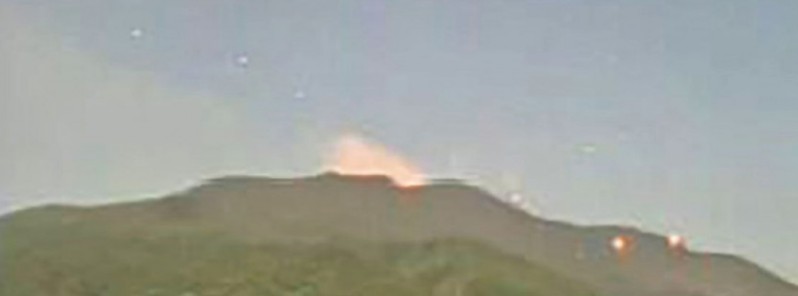
Image credit: JMA
Two strong eruptions were recorded at Suwanosejima volcano, Kagoshima prefecture, Japan on March 30, 2021, ejecting large rocks nearly 1 km (0.62 miles) from the crater and prompting the Japan Meteorological Agency (JMA) to raise the alert level to 3 (on a scale of 1 to 5) at 18:30 UTC (03:30 JST, March 31).
The first eruption took place at Mt. Otake crater at 13:05 UTC, followed by another one at 17:57 UTC, with volcanic material ejected nearly 1 km (0.62 miles) from the crater.
JMA warns big rocks from the volcano could be ejected as far as 2 km (1.2 miles) from the crater.
The agency is urging residents and tourists to refrain from entering the danger zone.
There were no immediate reports of injuries.
The last significant eruption at Suwanosejima took place at 17:51 UTC on December 27, 2020 (02:51 JST, December 28).
Frequent low-level ash emissions continued through March, with strombolian activity recorded throughout most of February and March.
#volcan #volcano #Suwanosejima Une belle activité strombolienne à l'air de se poursuivre dans le cratère sommital/Seems that a nice strombolian activity is ongoing in the summit crater pic.twitter.com/WzaKS1MmXD
— CultureVolcan (@CultureVolcan) March 2, 2021
Geological summary
The 8 km (5 miles) long, spindle-shaped island of Suwanosejima in the northern Ryukyu Islands consists of an andesitic stratovolcano with two historically active summit craters. The summit is truncated by a large breached crater extending to the sea on the east flank that was formed by edifice collapse.
Suwanosejima, one of Japan's most frequently active volcanoes, was in a state of intermittent strombolian activity from Otake, the NE summit crater, that began in 1949 and lasted until 1996, after which periods of inactivity lengthened.
The largest historical eruption took place in 1813 – 14 when thick scoria deposits blanketed residential areas, and the SW crater produced two lava flows that reached the western coast.
At the end of the eruption, the summit of Otake collapsed forming a large debris avalanche and creating the horseshoe-shaped Sakuchi caldera, which extends to the eastern coast.
The island remained uninhabited for about 70 years after the 1813 – 14 eruption.
Lava flows reached the eastern coast of the island in 1884.
Only about 50 people live on the island.
I'm a dedicated researcher, journalist, and editor at The Watchers. With over 20 years of experience in the media industry, I specialize in hard science news, focusing on extreme weather, seismic and volcanic activity, space weather, and astronomy, including near-Earth objects and planetary defense strategies. You can reach me at teo /at/ watchers.news.
Commenting rules and guidelines
We value the thoughts and opinions of our readers and welcome healthy discussions on our website. In order to maintain a respectful and positive community, we ask that all commenters follow these rules.