
Volcanic eruption in Geldingadalir continues, lava flow steady at 5 – 7 m3 per second, Iceland
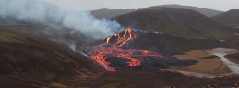
Image credit: IMO
The volcanic eruption in Geldingadalir, Reykjanes Peninsula, Iceland has now been ongoing for 9 days, with lava flowing steadily at 5 to 7 cubic meters per second, the Icelandic Met Office (IMO) reported on March 29, 2021.
A lot of data has been collected since the eruption started, including on-site and remote measurements along with modeling work forecasting the event's possible behavior over the coming days.
The lava is basaltic and highly fluid with little explosive activity, IMO said.
"It is a very small eruption and the lava flow has been steady at 5 – 7 m3 per second since its onset."
Currently, the extent of the lava field is within Geldingadalur but if the eruption keeps ongoing at a similar rate, it is modeled that the lava will flow east towards Merardalur valley.
The current magma is rich in MgO (8.5%) which indicates that it is coming from depths of around 17 – 20 km (10.5 – 12.4 miles).
There has been constant gas pollution close to the eruption site, spatially determined by local wind conditions.
Gases can accumulate to life-threatening levels in certain weather conditions, IMO warns.
There have been no indications of significant tectonic movements since the eruption started and there are currently no indications of new openings at other locations along the magma injection path.
Insane overhead drone footage of Iceland's Reykjanes eruption, captured by photographer Garðar Ólafs. https://t.co/RjmxZnIbek pic.twitter.com/faha49MQTS
— Corey S. Powell (@coreyspowell) March 28, 2021
"This eruption calls for specific and targeted monitoring of the eruption itself and also of the gas's effects on air quality and the downwind environment," IMO said.
If the volcano continues to erupt it could eventually end up being categorized as a shield volcano.
This type of volcanoes are generally formed over long time periods with lava fields extending from a few to several kilometers around its source.
There is no way to tell how long the eruption will last.
The most Icelandic video you will see today pic.twitter.com/YBAaDoJ3il
— Scott Duncan (@ScottDuncanWX) March 28, 2021
The volcano itself was a spectacular and mesmerising sight pic.twitter.com/PbyPeVhE2l
— Rut Einarsdóttir (@ruteinars) March 28, 2021
Geological summary
The Krýsuvík-Trölladyngja volcanic system is described by the Catalogue of Icelandic Volcanoes as an approximately 50 km (31 miles) long composite fissure swarm trending about N38°E, including a 30 km (18 miles) long swarm of fissures, with no central volcano.
It is one of the volcanic systems arranged en-echelon along the Reykjanes Peninsula west of Kleifarvatn lake.
The Fagradalsfjall and Krýsuvík fissure swarms are considered splits or secondary swarms of the Krýsuvík–Trölladyngja volcanic system.
Small shield volcanoes have produced a large portion of the erupted volume within the system.
Several eruptions have taken place since the settlement of Iceland, including the eruption of a large basaltic lava flow from the Ogmundargigar crater row around the 12th century.
The latest eruption, identified through tephrochronology, took place during the 14th century.
I'm a dedicated researcher, journalist, and editor at The Watchers. With over 20 years of experience in the media industry, I specialize in hard science news, focusing on extreme weather, seismic and volcanic activity, space weather, and astronomy, including near-Earth objects and planetary defense strategies. You can reach me at teo /at/ watchers.news.
What’s the OBSESSION with this particular volcano???