
Rare snow blankets Southern California, potent winter storms to bring more this week
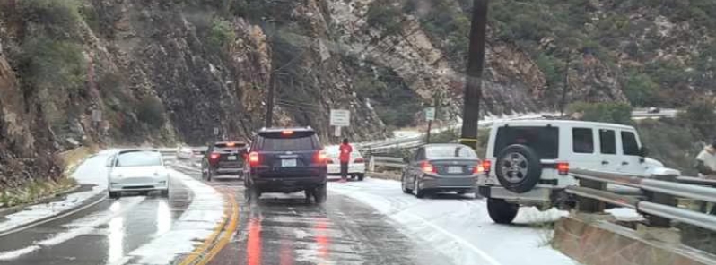
Image credit: LASD Lost Hills Station
Southern California residents woke up to a surprising sight on Saturday, January 23, 2021, as rare snow dusted parts of the region, including Malibu, where significant snow has not fallen for years. Meanwhile, a pair of potent winter storms are forecast to unleash further snow across the state this week, bringing also a threat of flooding and landslides.
An intense winter storm brought snow, hail, and rain across the state's southern region over the weekend. Residents in Malibu were caught by surprise as it was the second time in two years that the local hills were blanketed in white and the city has not received significant snow in years.
Some locals said the last time they saw snow in Malibu was almost exactly 14 years ago, on January 17, 2007.
Hail and rain also hit parts of Los Angeles, as well as northwest of Oxnard. The California Highway Patrol reported that multiple drivers stopped near the Malibu Canyon Tunnel to play in the snow.
However, the unexpected snowfall also caused a couple of road accidents in the area, including a wreck near Newton Canyon where one person had to be airlifted to a hospital after sustaining injuries.
Many residents took to social media to share photos of snow-covered roadways and streets, which included a plow truck clearing the roads.
"The highest elevation where this took place, Malibu Canyon Road, is about 500 feet [150 m] above sea level and weaves in and out of the higher terrain east of the Californian coast. The wintry precipitation that fell in this canyon in Malibu California is what is known as graupel," AccuWeather meteorologist Nicole LoBiondo explained.
"The temperatures at the surface along this canyon road must have been near freezing, which allowed for these ice pellets to fall and accumulate on untreated surfaces."
"Also due to the lack of sunshine on Saturday in the area, surfaces did not get a chance to absorb the sun's radiation and therefore, remained around the same temperature as the ambient air temperature."
SNOW IN MALIBU
With the first major storm of the season, it’s looking a lot like winter in #Malibu today. Lost Hills Sheriff Department is warning residents to stay safe & slow down on the roads after a car rolled over in Malibu Canyon, according to @LHSLASD.
Sydney Griffith pic.twitter.com/2qB56eSLPP— Pepperdine Graphic (@PeppGraphic) January 24, 2021
Gotta love california. 75 degrees at the beach , and then snow just 2 days later. So much beauty here … #malibu #socal pic.twitter.com/0prKzFMTzC
— CAMIZ (@Camillemarieg) January 24, 2021
Deputies assisting CHP – West Valley on another roll over, this one is on Malibu Canyon… and yes that is snow on the ground. If you need to be on the roads, please #slowdown and keep your eyes on the road. @thelocalmalibu @MalibuNews @acornnewspaper @TheMalibuTimes @991KBU pic.twitter.com/mgOPXWp6rp
— LASD Lost Hills Stn. (@LHSLASD) January 24, 2021
Malibu got some hail today, while Angeles National Highway has been shut down due to snow, as SoCal gets hit with winter weather. https://t.co/VSLuhA7nrn pic.twitter.com/9eWJFIBgbJ
— NBC Los Angeles (@NBCLA) January 24, 2021
A pair of powerful winter storms are set to bring more snow across California this week, with extreme precipitation totals expected, as well as threats of flooding and mudslides. By the end of the week, more than 3 m (10 feet) of snow is possible in sky country and in the Sierra Nevada.
"Heavy lower elevation rain [is set] to move into northern/central California Tuesday night (January 26), along with extreme snowfall amounts across the Sierra Nevada," the National Weather Service (NWS) wrote.
"Several feet of snow will add up through Wednesday night, with road closures and travel delays likely."
Flash flood and high wind watches are in effect for the San Francisco Bay area as rainfall totals of up to 102 mm (4 inches) and wind gusts of up to 113 km/h (70 mph) are likely.
The system will also impact the Los Angeles metro area late in the week, with high winds and heavy rain to hit the Sacramento River Valley.
Commenting rules and guidelines
We value the thoughts and opinions of our readers and welcome healthy discussions on our website. In order to maintain a respectful and positive community, we ask that all commenters follow these rules.