
Very rare January tornadoes touch down in California
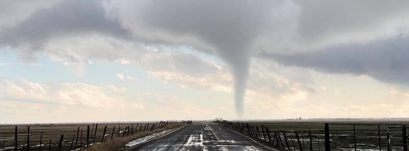
Featured image: Tornado north of Chico, California on January 4, 2021. Credit: Steve Walton
The National Weather Service (NWS) confirmed that two tornadoes touched down in Tehama County, California on Monday, January 4, 2021.
In the NWS Sacramento forecast area there were 39 tornadoes reported from 2010 – 2020.
This works out to about 4 tornadoes a year, making yesterday's twisters very rare occurrences. Two January tornadoes were also reported in 2017.
The first tornado touched down around 21:34 UTC (13:34 LT) near the city of Corning, downing trees and power lines and causing other structural damage.
According to NWS Sacramento meteorologist Eric Kurths, reports of additional damage are under investigation, including some reports of Cal Fire-Butte County.
The second tornado touched down in the open field near Vina around 21:40 UTC, causing no apparent damage. Multiple photos and videos confirm a tornado in clear contact, NWS said.
According to Kurths, the strong line of local thunderstorms may have combined with a high sheer environment which means it helped produce rotational wind energy.
The tornado wind speeds may have been in the 105 – 130 km/h (65 – 80 mph) range, he added.
"This is typical of tornadoes seen in the north state, but more data is currently being collected."
The storm left nearly 5 000 Tehama County residents without power.
Check out this awesome video from my friend and fellow @UWAtmosSci alum Brad Wilmot, who saw what is likely the second tornado of 2021 in the United States near Chico, California, earlier this afternoon. Thanks for letting me share, Brad! #cawx #tornado pic.twitter.com/MChecuYHmG
— Nathan Santo Domingo (@NSDwx) January 5, 2021
Here's a great photo of today's tornado in Tehama county taken by Derrick Baker. Thank you for sharing! Does anyone else have photos or videos? pic.twitter.com/uI0GxqnXPz
— Bryan Ramsey (@weatheramsey) January 4, 2021
A lull in the active weather is currently settling into the Pacific Northwest as the antecedent frontal system moves farther inland across the northern and central Rockies, NWS forecaster Kong said.
However, more active weather systems from the northeastern Pacific Ocean will bring additional heavy precipitation into much of the Pacific Northwest for the next couple of days.
This next episode of heavy precipitation is forecast to arrive later today (LT, January 5), resulting in an additional 150 to 300 mm (6 to 12 inches) of snow across the Olympic and Cascade mountains into parts of the northern Rockies through Wednesday.
Meanwhile, rainfall amounts of up to 75 mm (3 inches) are possible along the Coastal Ranges of Washington and Oregon to the immediate coast before this latest episode of heavy rain lets up by Thursday morning, January 7.
I'm a dedicated researcher, journalist, and editor at The Watchers. With over 20 years of experience in the media industry, I specialize in hard science news, focusing on extreme weather, seismic and volcanic activity, space weather, and astronomy, including near-Earth objects and planetary defense strategies. You can reach me at teo /at/ watchers.news.
Commenting rules and guidelines
We value the thoughts and opinions of our readers and welcome healthy discussions on our website. In order to maintain a respectful and positive community, we ask that all commenters follow these rules.