
Unusually large tornado hits Sakaka, Saudi Arabia – one of the largest ever documented in the country
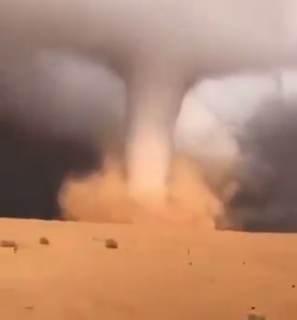
Image credit: Majid Al-Falih
A massive tornado formed on the outskirts of Sakaka in Al Jawf, Saudi Arabia, on Saturday, December 5, 2020. Meteorologists said it was unusually big for the region and one of the largest tornadoes ever documented in the country.
The incredible tornado occurred in the middle of the desert and reached an uninhabited area, according to Metsul Meteorologia.
"Weather radars captured the storm supercell responsible for the tornado in Al-Jawf Province in northern Saudi Arabia," it stated. The storm system also brought heavy rain and hail.
The meteorological authority added that among the affected regions wereTabuk, Hail, Al-Qassim, and parts of Madinah, Riyadh. Wind speeds were between 16 and 40 km/h (10 and 25 mph), while waves on the Red Sea reached up to 2 m (6.5 feet).
Tornado en Arabia Saudita
Hoy sábado diciembre 5 de 2020 cercano a la ciudad de Al Suqya
Créditos Majid Al-Falih
Vía @tqqs pic.twitter.com/ZGTWDSxgYh— Geól. Sergio Almazán (@chematierra) December 5, 2020
The tornado was unusually large for the region, according to local reports. It covered a small territory and moved very slowly. No injuries were reported, but authorities advised residents to stay indoors as the region is experiencing unpredictable weather conditions.
Abdullah Al-Misnad, professor of Climate Change and Department of Geography at the University of Casim, noted that it was one of the biggest tornadoes ever recorded in the region.
"The tornado, which formed southeast of Al-Jawf is one of the largest hurricanes that has been documented with pictures in Saudi Arabia," Al-Misnad stated.
A tornado gets started by a horizontal temperature inversion rolling across the land that finally punches a hole through the inversion layer and turns into a air whirlpool that sucks the warm air up through it.
It was noted on prior Solar Minimums that the polar cold is not as readily retained in that area and escapes to run south across areas that have warm air. The moisture it carries can no longer be sustained in the cooling mixture.
Severe storm require a large temperature difference to meet each other with the warm air carrying the moisture. It was noted during previous solar minimums that the polar cold is not as readily contained in the area around the poles. The worst effect is usually in the Spring when it kills farmers crops off. Though in our area the fruit trees got damaged in the fall by a quick shift into cold temperatures before the sap was pulled down to the roots.