
Eruption at Mount Merapi spews ash up to 5.9 km (19 098 feet) a.s.l., Indonesia
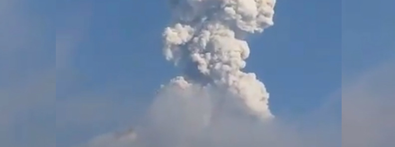
Image credit: Sukiman Lintas Merapi @SukimanMerapi
Authorities have issued an aviation warning following the eruption of Indonesia's Mount Merapi on October 14, 2019. The volcano, situated on the border of Central Java and Yogyakarta, erupted at 09:31 UTC (16:31 LT) and expelled a column of ash up to 5.9 km (19 098 feet), drifting southwest.
The eruption was recorded in seismograph for 270 seconds with an amplitude of 75 mm.
The best estimate of ash-cloud top is around 5 968 m (19 098 feet) above sea level, but may be higher than what could be observed clearly, PVMBG said.
Pyroclastic flow descended to the southwest of the crater.
No lava flows have been observed over the past 24 hours.
Get well soon #merapi pic.twitter.com/KQMqVwId2y
— Irawan_dani23 (@IDani23) October 14, 2019
Residents near the volcano have been warned of probable ash fall. Area within a radius of 3 km (2 miles) from the crater has been closed to the public.
Volcano monitoring disclosed #Merapi volcano's eruption at 16:31 WIB on 14 Oct 2019 spewing 3-km high ash plume that generated pyroclastic flows towards the SW – @jaimessincioco pic.twitter.com/u9O8J5x8ek
— Merapi News (@merapi_news) October 15, 2019
On September 20 to 26, PVMBG reported a gradual growth of the lava dome of the volcano. Lava fell into the upper parts of the SE flank, generating three block-and-ash flows that traveled as far as 1.5 km down the Gendol drainage.
Mount Merapi is one of the 129 active volcanoes in Indonesia. Since 1948, the volcano has regularly erupted. Thousands of locals reside on the slopes of the volcano.
Indonesia is one of the most disaster-prone nations on the planet. It sits along the Pacific Ring of Fire, where tectonic plates crash together and a huge portion of the Earth's volcanic explosions happen.
Geological summary
Merapi, one of Indonesia's most active volcanoes, lies in one of the world's most densely populated areas and dominates the landscape immediately north of the major city of Yogyakarta. It is the youngest and southernmost of a volcanic chain extending NNW to Ungaran volcano. Growth of Old Merapi during the Pleistocene ended with major edifice collapse perhaps about 2000 years ago, leaving a large arcuate scarp cutting the eroded older Batulawang volcano.
Subsequently, the growth of the steep-sided Young Merapi edifice, its upper part unvegetated due to frequent eruptive activity, began SW of the earlier collapse scarp. Pyroclastic flows and lahars accompanying growth and collapse of the steep-sided active summit lava dome have devastated cultivated lands on the western-to-southern flanks and caused many fatalities during historical time.
Commenting rules and guidelines
We value the thoughts and opinions of our readers and welcome healthy discussions on our website. In order to maintain a respectful and positive community, we ask that all commenters follow these rules.