
Extreme cold, another storm follow major Northeast winter storm
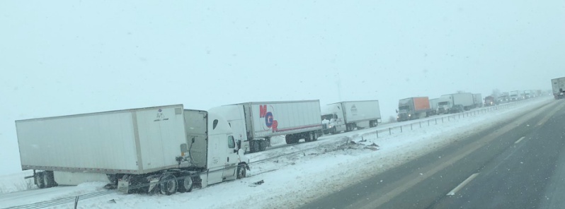
Image credit: Brandon O'Leary
A powerful winter storm hit parts of the United States, from the Midwest to the Northeast over the weekend, dropping heavy snow and rain and creating dangerously icy conditions. Areas of heavy snow will linger across portions of New England and downwind of the Great Lakes into Monday, January 21, 2019. Bitter cold and gusty winds behind the departing storm are resulting in dangerous wind chill temperatures for much of the Northeast corner of the U.S. In the west, heavy mountain snow will impact portions of Utah and Wyoming with high winds in the southwest Monday. Developing low pressure system currently bringing heavy snow over the Rockies will become the next winter storm for northern Plains to the Great Lakes
The storm has so far claimed lives of at least 10 people. 6 in California last week, two in Missouri, and one each in Kansas and Connecticut over the weekend.
"The storm pushed eastward out of the Rockies, continued through the Plains and into the Northeast. The stretch of snow of over a foot ranged from northeast Ohio through northern Pennsylvania and into New York, through Vermont and New Hampshire into Maine," AccuWeather Senior Meteorologist Alan Reppert said.
It caused severe traffic disruptions, hundreds of crashes and grounded more than 2 000 flights nationwide, with Boston's Logan Airport among the hardest hit.
A broad and energetic upper-level trough is currently moving across northern California where rain has been widespread, NWS meteorologist Kong noted Monday, January 21.
This system is expected to penetrate further inland and develop into a large low pressure system as it moves across the Rockies today, bringing widespread mountain snow from the Great Basin eastward into much of the northern and central Rockies.
The system will then exit the Rockies tonight and become the next winter storm for the northern Plains and expanding into the Great Lakes on Tuesday.
Up to 20 cm (8 inches) of snow can be expected over the upper Midwest on Tuesday, January 22. By Wednesday morning, January 23, the wintry precipitation should reach New England, with freezing rain possible over the northern and central Appalachians.
The storm will also tap into mild and moist air from the Gulf of Mexico. Rain is expected to expand across the lower and mid-Mississippi Valley on Tuesday near a warm front and ahead of a strong cold front. Some thunderstorms will be possible over the eastern Gulf states by Wednesday morning.
Frigid air from Canada will pour into the eastern United States in the wake of the major winter storm. High temperatures today will be more than 11 °C (20 °F) below normal across much of the Northeast.
In New England, they’ll fall to as low as -29 °C (-20 °F) around Boston and as low as -37 °C (-35 °F) in parts of Vermont, Maine and New Hampshire.
The flow of frigid air over the Great Lakes will promote lake-effect snow as well as upslope snowfall over parts of the central Appalachians through this evening, the service said.
Temperatures will begin to moderate on Tuesday as the arctic high pressure system slides off the East Coast.
Meanwhile, more active weather is forecast to reach the Pacific Northwest on Tuesday ahead of the next energetic Pacific cyclone. Expect coastal heavy rain and windy conditions to resume on Tuesday with snow spreading rapidly eastward into the Intermountain region Tuesday night, reaching the northern Rockies early on Wednesday, and into the northern High Plains Wednesday morning.
I'm a dedicated researcher, journalist, and editor at The Watchers. With over 20 years of experience in the media industry, I specialize in hard science news, focusing on extreme weather, seismic and volcanic activity, space weather, and astronomy, including near-Earth objects and planetary defense strategies. You can reach me at teo /at/ watchers.news.
Commenting rules and guidelines
We value the thoughts and opinions of our readers and welcome healthy discussions on our website. In order to maintain a respectful and positive community, we ask that all commenters follow these rules.