
EarthUncutTV visits Anak Krakatau, documents changes to the island and surrounding region
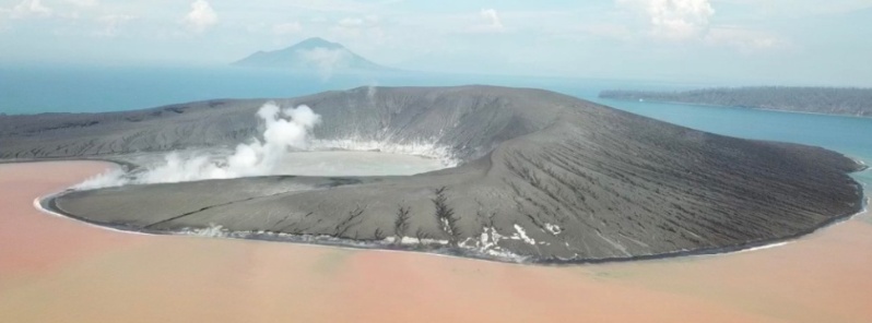
Featured image: Anak Krakatau on January 10, 2019. Credit: James Reynolds (EarthUncutTV). Used with permission.
James Reynolds of EarthUncutTV visited Anak Krakatau, Indonesia on January 10 and 11, 2019, documenting some of the dramatic changes to the island and the surrounding region after its recent eruptions and devastating tsunami on December 22.
At least 431 people have been killed, 7 200 were injured and 15 are still missing after the tsunami hit villages located around Sunda Strait, BNPB said December 29. 46 646 people have been displaced.
At least 1 778 homes have been damaged, 69 hotels were severely damaged as well as 78 small commercial units and 434 boats and ships.
According to the Darwin VAAC advisory issued 00:25 UTC, December 23, satellite imagery suggested a high-level eruption, with ash rising up to 16.7 km (55 000 feet) above sea level.
To complement these images, here's another gallery showing activity at Anak Krakatau over the past 10 days.
Images and videos were taken by Øystein Lund Andersen who was on the island of Java with his family when first tsunami waves hit.
Here's another interesting video document for the archives.
This is an interview with an Indonesian fisherman who was at Krakatau during the collapse and tsunami on December 22. His account is frightening, but also contains great bravery and sheds important light on details on what happened at Anak Krakatau that day.
Translation and interview summary courtesy Øystein Lund Andersen.
The man in the interview, Roni said the eruption of Krakatau climaxed before the tsunami, and that the eruption around 20:00 in the evening became different than what they have seen before. Lightning was produced by the volcano.
He got a lot of fish this day, much more than normal. However, because of the condition, the fishermen decided to return home early. But suddenly huge waves arrived without a warning.
Roni said he could see the Island of Sertung (3 km / 1.8 miles from Anak Krakatau) became engulfed in water. There were maybe as much as 4 waves. One was maybe 25 m (82 feet) tall, as it was taller than the trees on the island, he says. He could see clearly, as the moon was up that evening.
Another fisherman who survived told Rony he saw [part of the moutain] collapse. Two of the tsunami waves were particularly big. He was thrown out at sea. The water receded, and another wave hit. He thought he would die.
He and his friend made it to Sertung Island, located 2 km (1.2 miles) from Anak Krakatau. He went up the forest and he used a rope to tie himself to a tree, and stayed there all night until the morning. Next morning he found that few other fishermen had also survived.
They stayed on Sertung Island from Sunday to Thursday (5 days, December 23 – 27). He said they were starving, surviving on coconuts. On Thursday morning, the 4 of them decided to try to swim to Sebesi Island, the closest inhabited island.
They made a raft made of tree-debris so they could hold on to. They reached Sebesi the next morning, approx 24 hours later. Only 3 of them made it, one got separated and perished at sea.
According to Rony, there were 15 fishermen at Krakatau on the day of the tsunami. 7 have returned home, 1 died and 7 others are missing.
The following video is a timelapse of activity at the volcano on January 4:
Geological summary
The renowned volcano Krakatau (frequently misstated as Krakatoa) lies in the Sunda Strait between Java and Sumatra. The collapse of the ancestral Krakatau edifice, perhaps in 416 CE, formed a 7-km-wide (4.3 miles) caldera.
Remnants of this ancestral volcano are preserved in Verlaten and Lang Islands; subsequently Rakata, Danan and Perbuwatan volcanoes were formed, coalescing to create the pre-1883 Krakatau Island. Caldera collapse during the catastrophic 1883 eruption destroyed Danan and Perbuwatan volcanoes, and left only a remnant of Rakata volcano.
This eruption, the 2nd largest in Indonesia during historical time, caused more than 36 000 fatalities, most as a result of devastating tsunamis that swept the adjacent coastlines of Sumatra and Java. Pyroclastic surges traveled 40 km (25 miles) across the Sunda Strait and reached the Sumatra coast.
After a quiescence of less than a half century, the post-collapse cone of Anak Krakatau (Child of Krakatau) was constructed within the 1883 caldera at a point between the former cones of Danan and Perbuwatan. Anak Krakatau has been the site of frequent eruptions since 1927. (GVP)
I'm a dedicated researcher, journalist, and editor at The Watchers. With over 20 years of experience in the media industry, I specialize in hard science news, focusing on extreme weather, seismic and volcanic activity, space weather, and astronomy, including near-Earth objects and planetary defense strategies. You can reach me at teo /at/ watchers.news.
Commenting rules and guidelines
We value the thoughts and opinions of our readers and welcome healthy discussions on our website. In order to maintain a respectful and positive community, we ask that all commenters follow these rules.