
Indonesian authorities warn of increased activity at Mount Anak Krakatau
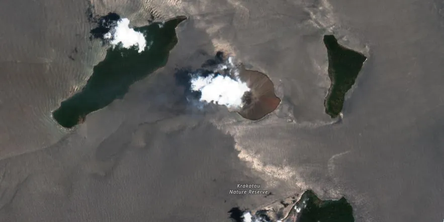
Featured image: Satellite image of Anak Krakatau volcano on October 29, 2023. Credit: Copernicus EU/Sentinel-2, EO Browser, The Watchers
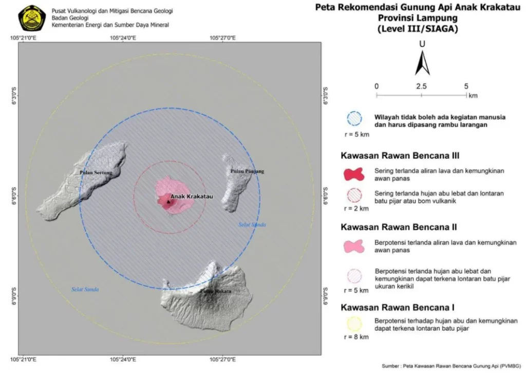
Seismic activity at Mount Anak Krakatau intensified on October 28, 2023, prompting Indonesian authorities to issue a 5 km (3.1 miles) exclusion zone around the main crater. The heightened activity included a range of earthquakes and internal vibrations indicative of potential eruptions.
Seismic readings from October 28 indicated internal continuous vibrations, known as tremors, with a maximum amplitude of 76 mm. These vibrations signal the movement of magma and the exsolution of volcanic gases through the conduit. Such conditions could lead to explosive, effusive, or combined forms of eruptions. During the same period, 50 deep volcanic earthquakes, 43 shallow volcanic earthquakes, and 37 hybrid ones were recorded.
Electronic tilt devices have been monitoring the ongoing inflation of the volcano’s edifice, registering a range between 15 – 50 microradians. This measurement indicates an increased internal pressure, corroborating the seismic data.
Visual accounts have noted passive emissions of gas and steam rising approximately 25 – 30 m (82 – 98 feet) above the cinder cone. These observations underscore the heightened state of activity but do not yet confirm an imminent eruption.
The potential reach for ballistic impacts of volcanic bombs, blocks, and incandescent material is currently about 2 km (1.2 miles) from the main crater. An exclusion zone of 5 km (3.1 miles) has been established around the main crater to mitigate risks, particularly for mariners.
Mount Anak Krakatau remains a point of concern due to its continuous eruptive activities since its 2018 eruption, which dramatically altered its morphology and triggered a tsunami in December the same year. In 2023 alone, 415 earthquake eruptions have been recorded, with the eruption column heights varying between 50 – 3 500 m (164 – 11 483 feet) above the peak.
As of 08:00 on October 29, 2023, the activity level of Mount Anak Krakatau is still at Level II (Alert). The public is advised not to approach within a 5 km (3.1 miles) radius of the active crater. Areas beyond this radius are considered safe from the immediate threat of eruption, except for the possible distribution of volcanic ash, which is dependent on wind direction and speed.
The activity level and advisories may be re-evaluated based on significant changes in visual and instrumental observations, PVMBG said.
References:
1 Press Release PERKEMBANGAN AKTIVITAS VULKANIK G. ANAK KRAKATAU – PVMBG – October 29, 2023
The Watchers team and our contributors bring the latest on extreme weather, earthquakes, volcanic eruptions, space weather, and all things science. We're all about making sense of the natural world and keeping you informed on what’s happening. Got a tip or a question? Hit us up using the form at newstips!
Commenting rules and guidelines
We value the thoughts and opinions of our readers and welcome healthy discussions on our website. In order to maintain a respectful and positive community, we ask that all commenters follow these rules.