
Large pyroclastic flow at Merapi volcano, ashfall blankets nearby communities, Indonesia
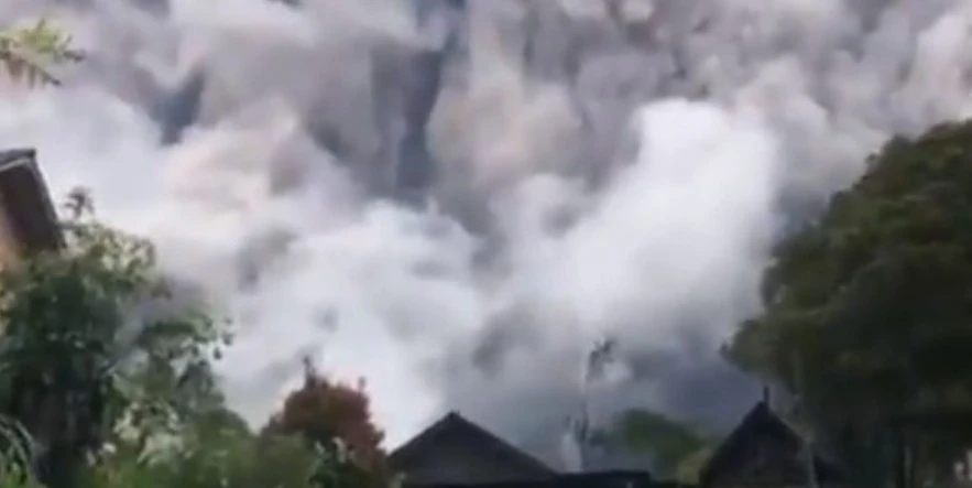
Image credit: BPPTKG
A significant eruption occurred at Indonesia’s Merapi volcano at approximately 06:55 UTC (13:55 local time) on January 21, 2024, producing a large pyroclastic flow that reached about 2 km (1.2 miles) from the summit. The eruption caused a large ash cloud and panic but no fatalities or injuries have been reported. The Alert Level remains at 3 (on a scale of 1 – 4).
Indonesia’s Merapi volcano, known for its frequent activity, erupted massively around 13:55 local time on January 21, 2024. This eruption was accompanied by a significant pyroclastic flow (PDC), which traveled through the Bebeng/Krasak ravine on the volcano’s southeastern flank. The flow extended approximately 2 km (1.2 miles) from the summit, alarmingly close to populated areas.
Agus Budi Santoso, the head of Indonesia’s Geological Disaster Technology Research and Development Center, reported that the eruption propelled a column of hot clouds about 100 m (330 feet) into the air. The resultant ash fall affected several villages, causing widespread panic among the residents.
Similar activity continued throughout the day and into January 22.
As of now, there have been no confirmed fatalities or injuries. However, the full extent of the impact in the areas hit by the pyroclastic flow remains unclear, with information still being gathered.
Saat ini angin disekitar puncak Gunung Merapi dominan ke arah Timur, dilaporkan wilayah lereng timur terdampak hujan abu vulkanik. Gunakan, masker dan kacamata. Hindari aktivitas diluar ruangan hingga hujan abu reda. Hati-hati berkendara kondisi jalan licin akibat abu vulkanik. pic.twitter.com/xFxjrhQKq9
— BPPTKG (@BPPTKG) January 21, 2024
Video kiriman Warga Merapi di sekitar wilahay Cepogo, Boyolali siang ini. #aktivitasmerapi #siagamerapi pic.twitter.com/OEXWey68DP
— BPPTKG (@BPPTKG) January 21, 2024
INFO BPPTKG:Terjadi Awan Panas Guguran di Gunung #Merapi tanggal 21 Januari 2024 pukul 13:55 WIB, dengan Amplitudo max 42 mm. Durasi 214.40 detik, jarak luncur maksimal 2000 meter ke Barat Daya (Kali Bebeng). Visual Gunung Merapi berkabut dan arah angin ke Timur. pic.twitter.com/DvXOZwL39e
— BPPTKG (@BPPTKG) January 21, 2024
For January 5 – 11, 2024, BPPTKG reported a total of 189 lava avalanches from the SW lava dome that descended the S, SW, and W flanks. Eight of them traveled S as far as 1.5 km (0.9 miles) down the upper part of the Boyong drainage, 178 traveled SW as far as 1.8 km (1.1 miles) down the upper part of the Bebeng drainage, and three traveled as far as 1.5 km (0.9 miles) down the Sat/Putih drainage. Four pyroclastic flows descended the Boyong and Bebeng drainages as far as 1.5 km (0.9 miles). Morphological changes to the SW lava dome identified in webcam images were due to continuing collapses of material.
Merapi is the most active of Indonesia’s 120-plus volcanoes. This eruption is the latest significant event since the volcano’s alert level was raised to the second-highest in November 2020, following the detection of increased volcanic activity. Residents living on Merapi’s slopes had been advised to maintain a safe distance of at least 7 km (4.3 miles) from the crater to avoid potential lava flows.
The volcano’s history is marked by deadly eruptions, including a significant event in 2010 that resulted in the deaths of 347 people and displaced about 20 000 villagers. Its proximity to Yogyakarta, a city rich in Javanese culture and history, adds to the concern, as roughly a quarter million people reside within a 10 km (6.2 miles) radius of Merapi.
References:
1 Indonesia’s Mount Merapi unleashes lava as other volcanoes flare up, forcing thousands to evacuate – AP – January 21, 2024
2 Global Volcanism Program, 2024. Report on Merapi (Indonesia) (Sennert, S, ed.). Weekly Volcanic Activity Report, 10 January-16 January 2024. Smithsonian Institution and US Geological Survey.
I'm a dedicated researcher, journalist, and editor at The Watchers. With over 20 years of experience in the media industry, I specialize in hard science news, focusing on extreme weather, seismic and volcanic activity, space weather, and astronomy, including near-Earth objects and planetary defense strategies. You can reach me at teo /at/ watchers.news.
Commenting rules and guidelines
We value the thoughts and opinions of our readers and welcome healthy discussions on our website. In order to maintain a respectful and positive community, we ask that all commenters follow these rules.