
Michael strengthening into a hurricane, heavy rainfall across western Cuba, Hurricane Watch for parts of Alabama and Florida
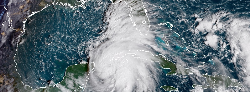
Featured image: Tropical Storm "Michael" at 13:10 UTC on October 8, 2018. Credit: NOAA/GOES-East
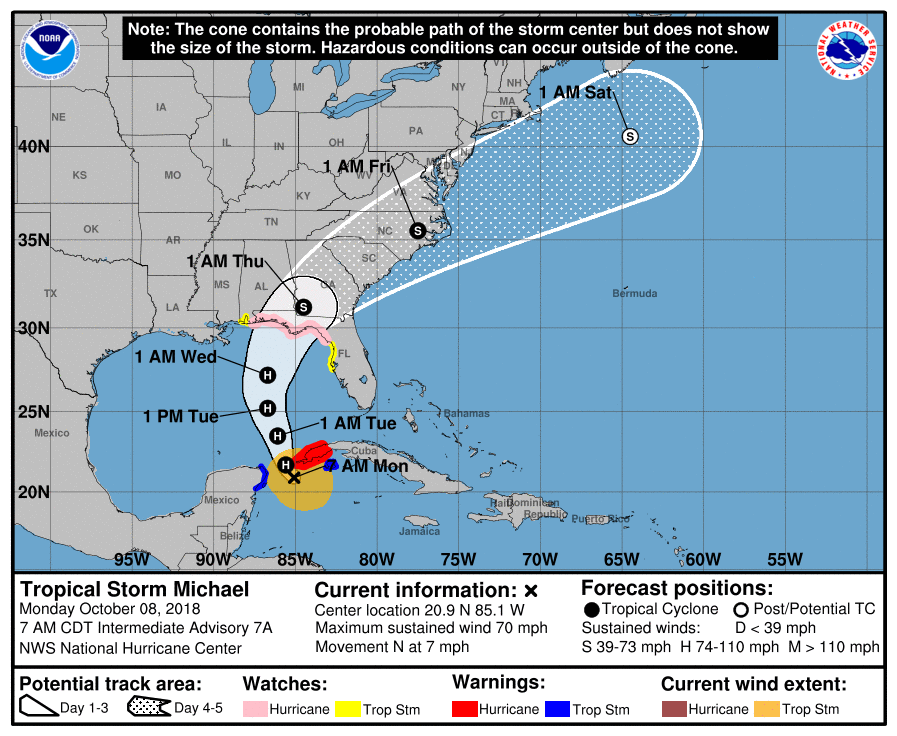
Tropical Storm "Michael" is strengthening and expected to become a hurricane very soon. A Hurricane Warning is in effect for the Cuban province of Pinar del Rio, a Tropical Storm Warning is in effect of the Cuban province of the Isle of Youth and the coast of Mexico from Tulum to Cabo Catoche, including Cozumel. A Storm Surge Watch is in effect for Navarre, Florida to Anna Maria Island, Florida, including Tampa Bay, a Hurricane Watch is in effect for Alabama-Florida to Suwanee River, Florida, and a Tropical Storm Watch is in effect for Suwanee River to Anna Maria Island, including Tampa Bay and Alabama Florida border to the Mississippi-Alabama border.
At 12:00 UTC on October 8 (07:00 CDT), the center of Tropical Storm "Michael" was located 190 km (120 miles) ENE of Cozumel, Mexico and 115 km (70 miles) S of the western tip of Cuba. Michael is moving toward the north near 11 km/ (7 mph) with maximum sustained winds of 110 km/h (70 mph) and minimum central pressure of 982 hPa.
A northward motion at a slightly faster forward speed is expected through Wednesday, October 10 and Thursday, October 11.
On the forecast track, the center of Michael will move northward across the Yucatan Channel today, and then across the eastern Gulf of Mexico this evening through Wednesday. Michael is expected to move inland over the Florida Panhandle or Florida Big Bend area on Wednesday, and then move northeastward across the southeastern United States Wednesday night and Thursday.
The storm is expected to produce heavy rainfall and flash flooding over portions of western Cuba and the northeastern Yucatan Peninsula of Mexico during the next couple of days.
Tropical Storm "Michael" at 13:10 UTC on October 8, 2018. Credit: NOAA/GOES-East
"Since the storm will still be over water for a time between 48 and 72 hours, there is a real possibility that Michael will strengthen to a major hurricane before landfall, NHC forecaster Berg said.
Some areas along the Florida Gulf Coast are especially vulnerable to storm surge, regardless of the storm's exact track or intensity. Residents in the watch areas should monitor the progress of this system and follow any advice given by local officials.
Weakening is expected after landfall, but the system will likely maintain tropical storm strength after October 12 when it moves off the east coast of the United States. Michael should then become an extratropical low by October 13.
On October 7, Florida Governor Rick Scott issued Executive Order 18-276 declaring a state of emergency in Escambia, Santa Rosa, Okaloosa, Walton, Holmes, Washington, Bay, Jackson, Calhoun, Gulf, Gadsden, Liberty, Franklin, Leon, Wakulla, Jefferson, Madison, Taylor, Hamilton, Suwannee, Lafayette, Dixie, Columbia, Gilchrist, Levy and Citrus counties, as the state continues to monitor and prepare for the storm.
By declaring this state of emergency, Governor Scott is ensuring that state and local government has ample time, resources and flexibility to get prepared for this storm.
Governor Scott is also urging all utilities and local partners to ensure mutual aid agreements are in place and review the number of generators they have to ensure they have all the resources needed.
Governor Scott also directed the Florida National Guard to activate 500 guardsmen to assist with planning and logistics, and to prepare for response in impacted areas.
I'm a dedicated researcher, journalist, and editor at The Watchers. With over 20 years of experience in the media industry, I specialize in hard science news, focusing on extreme weather, seismic and volcanic activity, space weather, and astronomy, including near-Earth objects and planetary defense strategies. You can reach me at teo /at/ watchers.news.
Commenting rules and guidelines
We value the thoughts and opinions of our readers and welcome healthy discussions on our website. In order to maintain a respectful and positive community, we ask that all commenters follow these rules.