
Strong and shallow M6.9 earthquake hits SW China / India border region
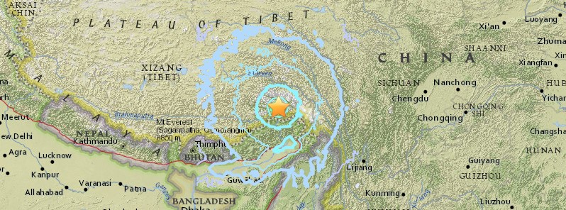
Image credit: USGS
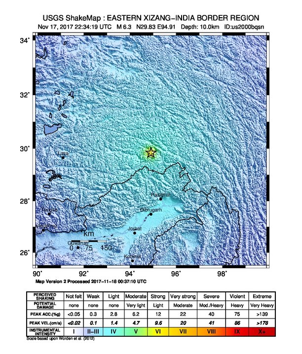
A strong and shallow earthquake registered by CENC (China) as M6.9 hit Milein County, Nyingchi City, Tibet (SW China / India border region) at 22:34 UTC on November 17, 2017 (06:34 local time, November 18). Both USGS and EMSC report it as M6.3 at a depth of 10 km (6.2 miles). USGS issued a green alert for shaking-related fatalities and yellow for economic losses.
According to the USGS, the epicenter was located 21 km (13 miles) ENE of Lunang (population 0), China and 184.9 km (114.9 miles) N of Along (population 18 425), India.
There are approximately 100 000 people living within 100 km (62 miles), and 16 000 within 50 km (31 miles).
Professor Max Wyss, who specializes in theoretical prognoses of injuries and fatalities expects 0 to 100 fatalities and 100 to 800 injuries, according to Earthquake Report.
At least two moderately strong aftershocks were registered by China Earthquake Networks Center (CENC): M4.0 at 22:37 UTC and M5.0 at 00:31 UTC (November 18). Both at a depth of 6 km (3.7 miles).
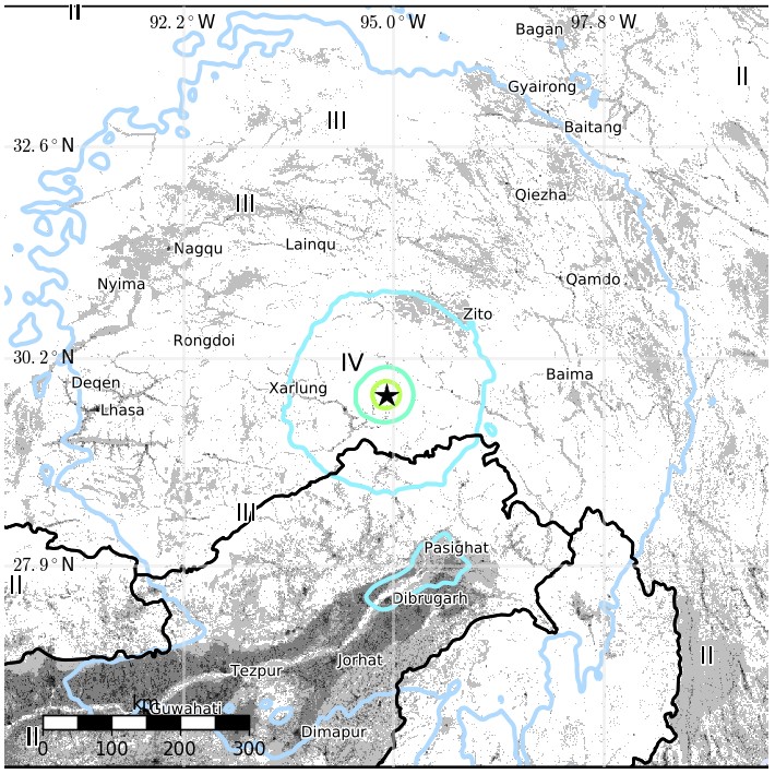
The USGS issued a green alert for shaking-related fatalities. There is a low likelihood of casualties.
A yellow alert was issued for economic losses. Some damage is possible and the impact should be relatively localized. Estimated economic losses are less than 1% of GDP of China. Past events with this alert level have required a local or regional level response.
Overall, the population in this region resides in structures that are vulnerable to earthquake shaking, though resistant structures exist. The predominant vulnerable building types are adobe block with wood and rubble/field stone masonry construction.
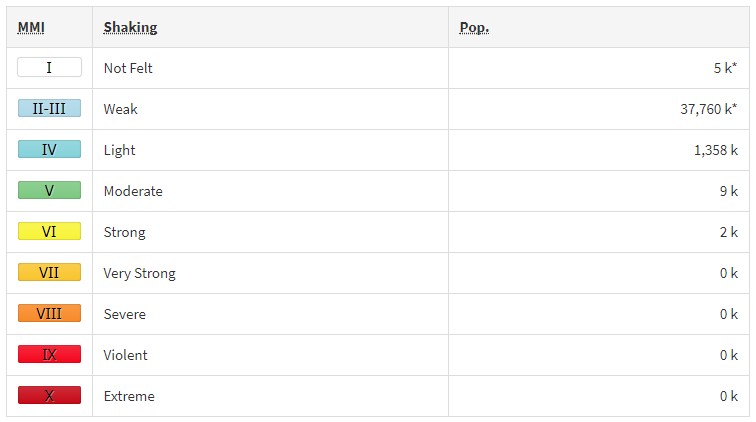
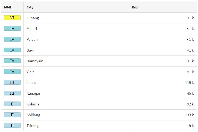
Estimated population exposure to earthquake shaking
Selected cities exposed
Regional seismicity
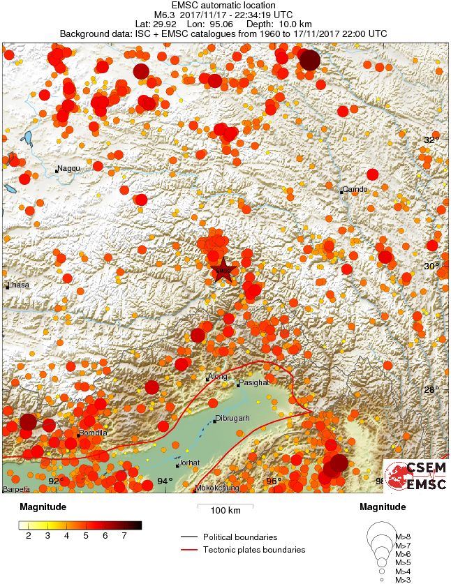
Seismotectonics of the Himalaya and Vicinity
Seismicity in the Himalaya dominantly results from the continental collision of the India and Eurasia plates, which are converging at a relative rate of 40-50 mm/yr. Northward underthrusting of India beneath Eurasia generates numerous earthquakes and consequently makes this area one of the most seismically hazardous regions on Earth. The surface expression of the plate boundary is marked by the foothills of the north-south trending Sulaiman Range in the west, the Indo-Burmese Arc in the east and the east-west trending Himalaya Front in the north of India.
The India-Eurasia plate boundary is a diffuse boundary, which in the region near the north of India, lies within the limits of the Indus-Tsangpo (also called the Yarlung-Zangbo) Suture to the north and the Main Frontal Thrust to the south. The Indus-Tsangpo Suture Zone is located roughly 200 km north of the Himalaya Front and is defined by an exposed ophiolite chain along its southern margin. The narrow (<200km) Himalaya Front includes numerous east-west trending, parallel structures. This region has the highest rates of seismicity and largest earthquakes in the Himalaya region, caused mainly by movement on thrust faults. Examples of significant earthquakes, in this densely populated region, caused by reverse slip movement include the 1934 M8.1 Bihar, the 1905 M7.5 Kangra and the 2005 M7.6 Kashmir earthquakes. The latter two resulted in the highest death tolls for Himalaya earthquakes seen to date, together killing over 100,000 people and leaving millions homeless. The largest instrumentally recorded Himalaya earthquake occurred on 15th August 1950 in Assam, eastern India. This M8.6 right-lateral, strike-slip, earthquake was widely felt over a broad area of central Asia, causing extensive damage to villages in the epicentral region.
The Tibetan Plateau is situated north of the Himalaya, stretching approximately 1000km north-south and 2500km east-west, and is geologically and tectonically complex with several sutures which are hundreds of kilometer-long and generally trend east-west. The Tibetan Plateau is cut by a number of large (>1000km) east-west trending, left-lateral, strike-slip faults, including the long Kunlun, Haiyuan, and the Altyn Tagh. Right-lateral, strike-slip faults (comparable in size to the left-lateral faults), in this region include the Karakorum, Red River, and Sagaing. Secondary north-south trending normal faults also cut the Tibetan Plateau. Thrust faults are found towards the north and south of the Tibetan Plateau. Collectively, these faults accommodate crustal shortening associated with the ongoing collision of the India and Eurasia plates, with thrust faults accommodating north south compression, and normal and strike-slip accommodating east-west extension.
Along the western margin of the Tibetan Plateau, in the vicinity of south-eastern Afghanistan and western Pakistan, the India plate translates obliquely relative to the Eurasia plate, resulting in a complex fold-and-thrust belt known as the Sulaiman Range. Faulting in this region includes strike-slip, reverse-slip and oblique-slip motion and often results in shallow, destructive earthquakes. The active, left-lateral, strike-slip Chaman fault is the fastest moving fault in the region. In 1505, a segment of the Chaman fault near Kabul, Afghanistan, ruptured causing widespread destruction. In the same region the more recent 30 May 1935, M7.6 Quetta earthquake, which occurred in the Sulaiman Range in Pakistan, killed between 30,000 and 60,000 people.
On the north-western side of the Tibetan Plateau, beneath the Pamir-Hindu Kush Mountains of northern Afghanistan, earthquakes occur at depths as great as 200 km as a result of remnant lithospheric subduction. The curved arc of deep earthquakes found in the Hindu Kush Pamir region indicates the presence of a lithospheric body at depth, thought to be remnants of a subducting slab. Cross-sections through the Hindu Kush region suggest a near vertical northerly-dipping subducting slab, whereas cross-sections through the nearby Pamir region to the east indicate a much shallower dipping, southerly subducting slab. Some models suggest the presence of two subduction zones; with the Indian plate being subducted beneath the Hindu Kush region and the Eurasian plate being subducted beneath the Pamir region. However, other models suggest that just one of the two plates is being subducted and that the slab has become contorted and overturned in places.
Shallow crustal earthquakes also occur in this region near the Main Pamir Thrust and other active Quaternary faults. The Main Pamir Thrust, north of the Pamir Mountains, is an active shortening structure. The northern portion of the Main Pamir Thrust produces many shallow earthquakes, whereas its western and eastern borders display a combination of thrust and strike-slip mechanisms. On the 18 February 1911, the M7.4 Sarez earthquake ruptured in the Central Pamir Mountains, killing numerous people and triggering a landside, which blocked the Murghab River.
Further north, the Tian Shan is a seismically active intra-continental mountain belt, which extends 2500 km in an ENE-WNW orientation north of the Tarim Basin. This belt is defined by numerous east-west trending thrust faults, creating a compressional basin and range landscape. It is generally thought that regional stresses associated with the collision of the India and Eurasia plates are responsible for faulting in the region. The region has had three major earthquakes (>M7.6) at the start of the 20th Century, including the 1902 Atushi earthquake, which killed an estimated 5,000 people. The range is cut through in the west by the 700-km-long, northwest-southeast striking, Talas-Ferghana active right-lateral, strike-slip fault system. Though the system has produced no major earthquakes in the last 250 years, paleo-seismic studies indicate that it has the potential to produce M7.0+ earthquakes and it is thought to represent a significant hazard.
The northern portion of the Tibetan Plateau itself is largely dominated by the motion on three large left-lateral, strike-slip fault systems; the Altyn Tagh, Kunlun and Haiyuan. The Altyn Tagh fault is the longest of these strike slip faults and it is thought to accommodate a significant portion of plate convergence. However, this system has not experienced significant historical earthquakes, though paleoseismic studies show evidence of prehistoric M7.0-8.0 events. Thrust faults link with the Altyn Tagh at its eastern and western termini. The Kunlun Fault, south of the Altyn Tagh, is seismically active, producing large earthquakes such as the 8th November 1997, M7.6 Manyi earthquake and the 14th November 2001, M7.8 Kokoxili earthquake. The Haiyuan Fault, in the far north-east, generated the 16 December 1920, M7.8 earthquake that killed approximately 200,000 people and the 22 May 1927 M7.6 earthquake that killed 40,912.
The Longmen Shan thrust belt, along the eastern margin of the Tibetan Plateau, is an important structural feature and forms a transitional zone between the complexly deformed Songpan-Garze Fold Belt and the relatively undeformed Sichuan Basin. On 12 May 2008, the thrust belt produced the reverse slip, M7.9 Wenchuan earthquake, killing over 87,000 people and causing billions of US dollars in damages and landslides which dammed several rivers and lakes.
Southeast of the Tibetan Plateau are the right-lateral, strike-slip Red River and the left-lateral, strike-slip Xiangshuihe-Xiaojiang fault systems. The Red River Fault experienced large scale, left-lateral ductile shear during the Tertiary period before changing to its present day right-lateral slip rate of approximately 5 mm/yr. This fault has produced several earthquakes >M6.0 including the 4 January 1970, M7.5 earthquake in Tonghai which killed over 10,000 people. Since the start of the 20th century, the Xiangshuihe-Xiaojiang Fault system has generated several M7.0+ earthquakes including the M7.5 Luhuo earthquake which ruptured on the 22 April 1973. Some studies suggest that due to the high slip rate on this fault, future large earthquakes are highly possible along the 65km stretch between Daofu and Qianning and the 135km stretch that runs through Kangding.
Shallow earthquakes within the Indo-Burmese Arc, predominantly occur on a combination of strike-slip and reverse faults, including the Sagaing, Kabaw and Dauki faults. Between 1930 and 1956, six M7.0+ earthquakes occurred near the right-lateral Sagaing Fault, resulting in severe damage in Myanmar including the generation of landslides, liquefaction and the loss of 610 lives. Deep earthquakes (200km) have also been known to occur in this region, these are thought to be due to the subduction of the eastwards dipping, India plate, though whether subduction is currently active is debated. Within the pre-instrumental period, the large Shillong earthquake occurred on the 12 June 1897, causing widespread destruction. (USGS)
I'm a dedicated researcher, journalist, and editor at The Watchers. With over 20 years of experience in the media industry, I specialize in hard science news, focusing on extreme weather, seismic and volcanic activity, space weather, and astronomy, including near-Earth objects and planetary defense strategies. You can reach me at teo /at/ watchers.news.
Commenting rules and guidelines
We value the thoughts and opinions of our readers and welcome healthy discussions on our website. In order to maintain a respectful and positive community, we ask that all commenters follow these rules.