
Powerful explosive eruption at Bogoslof, ash to 10.4 km (34 000 feet)
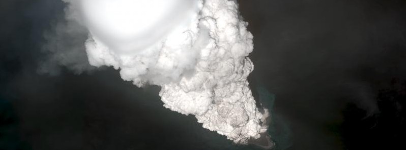
Image credit: Worldview satellite image collected at 22:34 UTC on May 28, 2017 showing the initial development of the eruption cloud from Bogoslof volcano. The eruption began about 18 minutes prior to this image and the cloud rose to an altitude in excess of 12.2 km (40 000 feet) above sea level. The white color of the eruption cloud is due to the large amount of water that is incorporated into the eruption column as the vent is located in shallow water. Image data provided under the Digital Globe NextView License.
A powerful explosive eruption took place at Bogoslof volcano on June 10, 2017, forcing officials to raise the Aviation Color Code to Red and Volcano Alert Level to Warning. It seems the eruption may have destroyed the lava dome emplaced last week.
The eruption lasted just over two hours, from 11:18 to 13:28 UTC. The sequence began with a series of infrasound signals and then, starting at about 12:16 UTC, transitioned into several minutes-long continuous seismic and infrasound tremor signals. Satellite images of the resulting cloud show it reached as high as 10.4 km (34 000 feet) above sea level and drifted to the northeast, Alaska Volcano Observatory reported.
Satellite data also indicate that at least part of the volcanic cloud was more ash-rich than most of those seen previously in the Bogoslof eruptive sequence to date. This suggests that the eruption may have destroyed the lava dome that was emplaced last week.
Since 13:28 UTC, seismicity as detected on neighboring islands has ben quiet, no lightning has been detected, and satellite images show no additional emission from the volcano.
At 23:01 UTC, AVO reported that there were no further emissions from the volcano, and lowered the Aviation Colore Code to Orange and Volcano Alert Level to Watch.
"Bogoslof volcano remains at a heightened state of unrest and in an unpredictable condition. Additional explosions producing high-altitude volcanic clouds could occur at any time. Low-level explosive activity that is below our ability to detect in our data sources may be occurring. These low-level explosions could pose a hazard in the immediate vicinity of the volcano," AVO warns.
Geological summary
Bogoslof is the emergent summit of a submarine volcano that lies 40 km (24.8 miles) north of the main Aleutian arc. It rises 1 500 m (4 920 feet) above the Bering Sea floor. Repeated construction and destruction of lava domes at different locations during historical time has greatly modified the appearance of this "Jack-in-the-Box" volcano and has introduced a confusing nomenclature applied during frequent visits of exploring expeditions.
The present triangular-shaped, 0.75 x 2 km (0.46 x 1.2 miles) island consists of remnants of lava domes emplaced from 1796 to 1992. Castle Rock (Old Bogoslof) is a steep-sided pinnacle that is a remnant of a spine from the 1796 eruption. Fire Island (New Bogoslof), a small island located about 600 m (1 970 feet) NW of Bogoslof Island, is a remnant of a lava dome that was formed in 1883. (GVP)
I'm a dedicated researcher, journalist, and editor at The Watchers. With over 20 years of experience in the media industry, I specialize in hard science news, focusing on extreme weather, seismic and volcanic activity, space weather, and astronomy, including near-Earth objects and planetary defense strategies. You can reach me at teo /at/ watchers.news.
Commenting rules and guidelines
We value the thoughts and opinions of our readers and welcome healthy discussions on our website. In order to maintain a respectful and positive community, we ask that all commenters follow these rules.