
Extraordinary high pressure pushing a cold surge to Northeast Asia
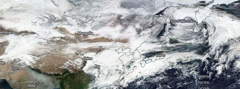
Image credit: NASA/NOAA/DoD Suomi NPP / VIIRS image acquired November 21, 2016.
Intense cold has gripped parts of Northeast Asia, causing severe temperature drops and gusty winds. Near record-breaking high sea level pressure was reported in northern Mongolia on November 21, 2016.
Siberia, bordering with Mongolia, is the heart of the Northeast Monsoon, and responsible for the winter weather conditions in the Northeast Asia. Frigid temperatures combined with such high pressure means the air circulation will be increased. The areas of high pressure will naturally flow toward the regions of lower pressure, so the air will travel southwards over the next few days, causing a potent cold surge, experts from the WestPacWX explained.
Extraordinary high press noted on 0z/3z 21 Nov KMA surface analysis in W Mongolia. Unconfirmed readings near 1085 mb. World rec is 1083.8mb. pic.twitter.com/V0ySHC0wAJ
— Anthony Sagliani (@anthonywx) November 21, 2016
The sea level pressure reported on November 21 reached 1 085.1 hPa in one area in Northern Mongolia, a value coming very close to the historical record of 1 090.1 hPa, recorded over 750 m, in 2004.
Video credit: WestPacWx
The cold surge will bring below freezing temperatures to Seoul, South Korea, during the middle of the week while Okinawa can expect the coldest air of the season and gusty winds. Temperatures in Tokyo will fall to a near freezing point by November 24, causing snowfall in the region.
If such a development occurs, it will be unprecedented for the month of November.
Currently, three different numerical models, the GFS, JMA, and ECMWF, forecast a wet snow accumulation for the morning of November 21 (local time). Generally, this doesn't happen until January, which means it would be a record early snowfall for the area. Widespread snowfall will also affect the mountainous regions of Japan.
Hi,
What is happening worldwide? It seems everything is accelerating very quickly…….