
New Zealand earthquake: One of the most complex ever recorded on land
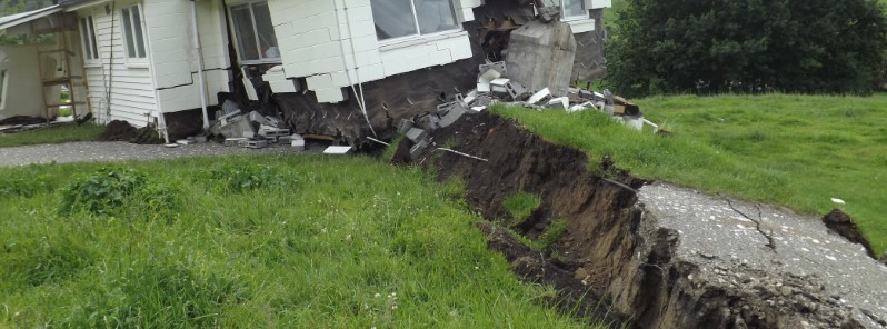
Image credit: GeoNet
New Zealand's GeoNet has revised their initial magnitude of the November 13, 2016 Kaikoura earthquake from M7.5 to M7.8. The agency added that early indications show this was one of the most complex earthquakes ever recorded on land.
"This complexity means we have had to take extraordinary efforts to determine the magnitude, depth, and locations," the agency said.
The very long time it took for the faults to rupture (over one minute) meant that the standard methods of calculating magnitude were insufficient to capture the full energy released.
Due to the size of the quakes, GeoNet gathered data from their entire network of seismic stations. All of these stations would not normally need to be included in magnitude estimates.
"Based on all ongoing efforts, we can say with some confidence that the earthquake was an M7.8. This is consistent with estimates from several other international agencies, specifically the USGS. Their early model provided us important information and we used all our additional data sets to confirm the magnitude."
"The new magnitude just tells us what we think most people who felt the earthquake already know: it was powerful, and went on for a long time over a large distance. It doesn’t change what happened but it does provide us with more knowledge about how significant the event was."
The recent analysis confirms the complexity of this event. It does not change any of the observations of strong ground motion, fault breaks or GPS recorded movement of the earth’s surface – these are physical observations independent of the magnitude of the earthquake.
Ground shaking caused by the Kaikoura Earthquake reached over MMI VIII near the fault rupture, on the Modified Mercalli Intensity Scale and is considered severe. In Wellington, some areas experienced shaking up to MMI VI-VII, which is considered strong. This is based on the current Shakemap calculation, which includes both measured data and estimated values.
GeoNet's director, Dr. Ken Gledhill, said 'it was a monster quake, one that has shocked us all with its intensity and ferocity. Because of its size, it made our world shake strongly but relatively slowly for a very long time.'
Gledhill briefly reflected on the supermoon connection and earthquake lights during the quake, saying that GeoNet just doesn't have any way to measure their effects using existing sensors. "So, I am just going to leave that topic for other people to discuss."
Multiple ruptures
Rapid field reconnaissance indicates that multiple faults have ruptured during the quake:
- Kekerengu Fault at the coast – appears to have had up to 10 m (32.8 feet) of slip
- Newly identified fault at Waipapa Bay
- Hope Fault – seaward segment – minor movement
- Hundalee Fault
"What we are finding in New Zealand is that quite a few of our larger earthquakes involve jumping from rupture on one plane to another in a complex sequence. We first saw that with the Darfield Sept 2010 EQ where multiple segments ruptured together as a single earthquake. We appear to have seen this again overnight."
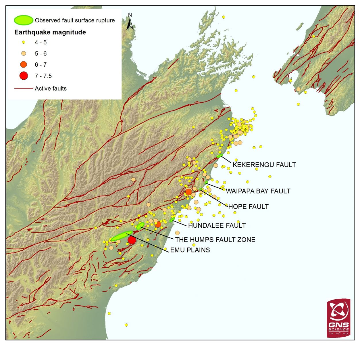
Map showing aftershocks and faults in the Marlborough area, including the portions where rupture was observed. Credit: GeoNet
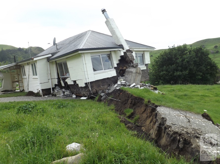
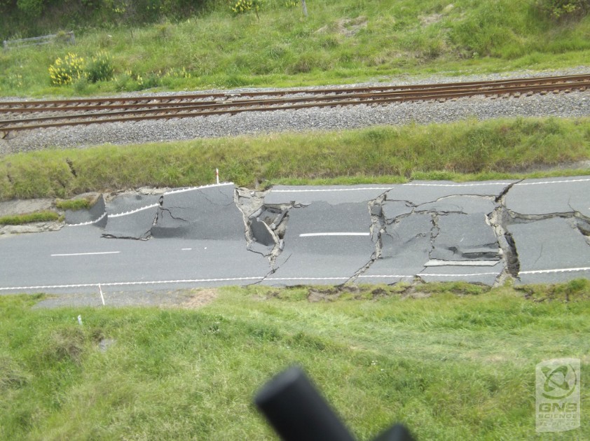
Bluff station. Kekerengu Fault rupture displacing the road and house by 10 metres (across two parallel fault traces, only one trace on the photo). Credit: GeoNet
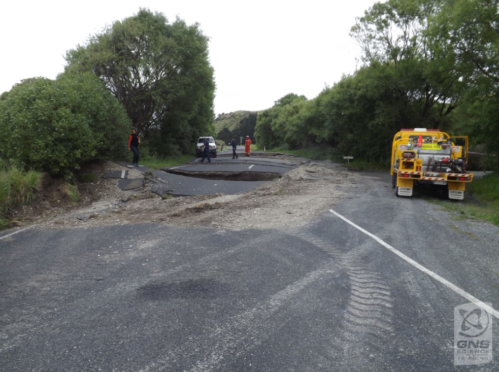
Kekerengu Fault surface rupture displacing State Highway 1. 34 cracks and faults were observed breaking the road. Credit: GeoNet
Rupture of the Hundalee Fault displacing SH1, the railway line. Credit: GeoNet
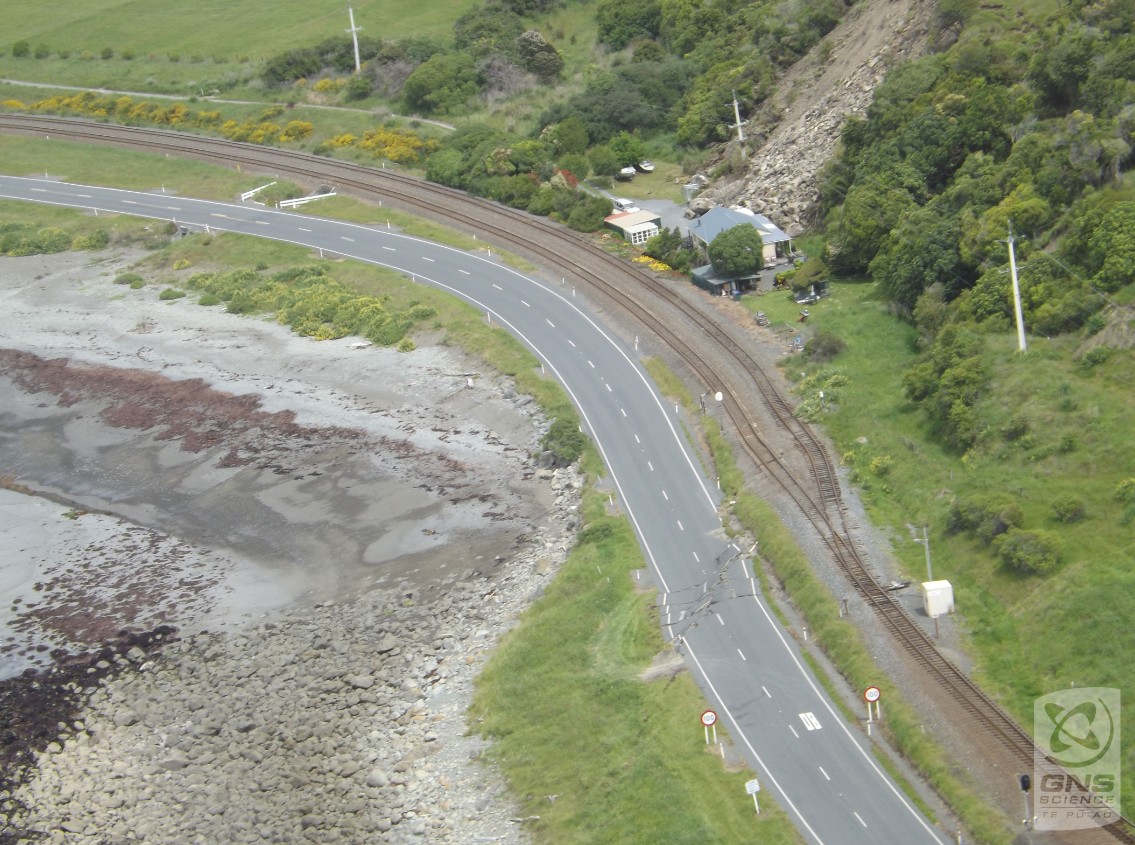
Rupture of the Hundalee Fault displacing SH1, the railway line and the beach. Credit: GeoNet
PGA Information
The strongest ground shaking measured by GeoNet instrumentation so far was a peak ground acceleration of (PGA) 1.3g in Ward.
The highest ground accelerations extend in a band trending northeast from the epicenter. This aligns with where the largest fault movements have occurred, based on field surveys.
In the Wellington region, PGAs exceeded 0.2g in parts of the CBD and Lower Hutt. This is similar to that experienced during the Cook Strait sequence (earthquakes of M6.6), however, the duration of shaking was significantly longer (around four times) and there was more long period energy.
In Christchurch, the recorded PGAs were lower (less than 0.1g) even though the city is closer to the epicenter. This is related to the fault rupturing from the epicenter northwards away from Christchurch.
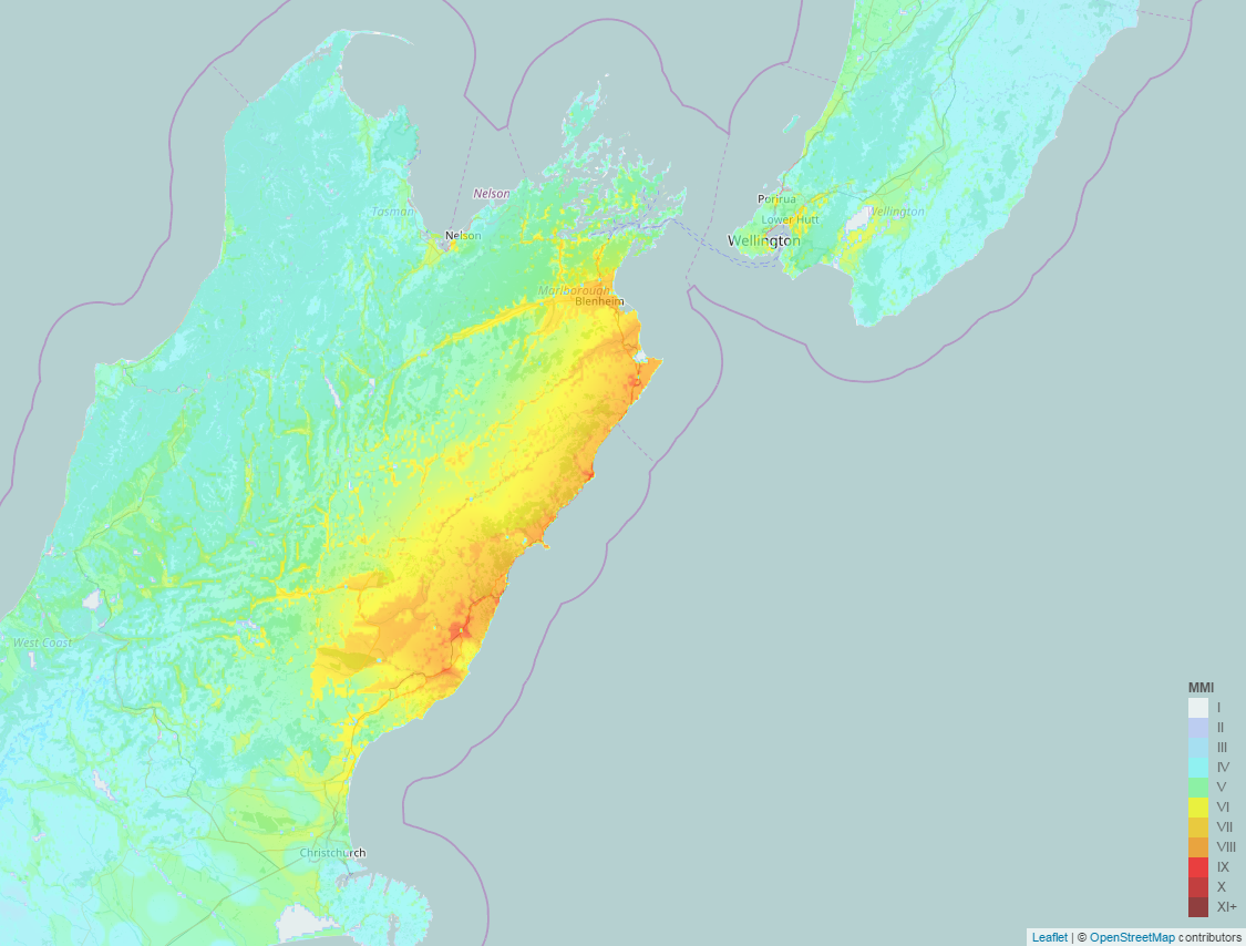
ShakeMap – Kaikoura earthquake of November 13, 2016 (ShakeMap version November 16). Credit: GeoNet
Long-term earthquake rates
There were more large earthquakes in a period of several decades prior to about 1950, and it has been relatively quiet since then. Since the M7.8 in July 2009 in Fiordland, that quiet period appears to be over.
The reason that there was a tsunami generated by an earthquake with an epicenter onshore is that there was deformation further down the fault plane offshore.
Wellington area
Wellington area faults and the subduction interface beneath Wellington are captured in the probability table and the scenarios given there.
"We do not have any evidence of an impending large earthquake of a similar size in Wellington at this stage but we cannot rule this out. We cannot make a calculation to predict this, but the chance of a further shock in the Wellington area has increased somewhat since the Kaikoura earthquake," GeoNet concluded.
The tsunami
Earliest reports by GeoNet say that there is only a little bit of tsunami damage on the coast. However, further impact assessments need to be performed before they can conclusively say this for the whole East Coast.
Landslides
A rough estimate based on initial reconnaissance flights is that there may have been from 80 0000 to 100 000 landslides. Much of the area affected by landslides is in the remote and rugged areas of the Inland and Seaward Kaikoura Ranges.
Satellite imagery from both before and after the earthquake is currently being sourced and will likely take at least two weeks because acquiring cloud-free imagery takes time. This will allow a change model to be developed telling us where the landslides have occurred.
The reports of landslide dams point to a potential developing hazard.
Landslide dams can last thousands of years, they can fail slowly or they can fail very quickly. When they fail very quickly they can release large volumes of water and sediment into river systems as a flood wave (flash flood). These floods can be hazardous to river users and GeoNet urged people to stay away from all rivers on the east coast of the South Island from the Hurunui to the Awatere until inspections have been completed and more precise information can be provided.
"Please exercise caution when in the vicinity of landslides and cracks in the ground on slopes. If it is raining the threat rises as the water can remobilize the debris as debris flows and debris floods (flash floods)."
Scenarios
GeoNet has developed three scenarios based on what they know so far, but be aware that their understanding is evolving as they do more analysis and receive more data.
There are very different probabilities for each scenario; some of these are more concerning than others.
Scenario One: Extremely likely (>99% within the next 30 days)
The most likely scenario is that aftershocks will continue to decrease in frequency (and in line with forecasts) over the next 30 days. Felt aftershocks (e.g. over M5) would occur from the M7.5 epicenter near Culverden, right up along the Kaikoura coastline to the Cape Palliser/Wellington area. This includes the potential for aftershocks of between 6.0 and 6.9 (91% within the next 30 days). Scenario one will continue to play out, even if either scenario two or three also occurs.
Scenario Two: Unlikely (15% within the next 30 days)
An earthquake smaller than Monday's mainshock and between M7.0 to M7.5. There are numerous mapped faults in the Marlborough or Cook Strait areas capable of such an earthquake. It may also occur on an unmapped fault. This earthquake may be onshore or offshore but close enough to cause severe shaking on land. This scenario includes the possibility of an earthquake in the Hikurangi Subduction Zone. Such earthquakes have the potential to generate a tsunami.
Scenario Three: Very unlikely (7% within the next 30 days)
A much less likely scenario than the previous two scenarios is that recent earthquake activity will trigger an earthquake larger than the M7.5 mainshock. This includes the possibility for an earthquake of greater than M8.0, which could be on the 'plate interface' (where the Pacific Plate meets the Australian Plate). Although it is still very unlikely, the chances of this occurring have increased since before the M7.5 earthquake.
Within this sequence, aftershocks will most likely occur anywhere in the box on the map (see image below). It is this geographical region for which the modeling is done. It is important to understand that earthquakes can and do happen outside this box but the box represents the most likely area related to this sequence.
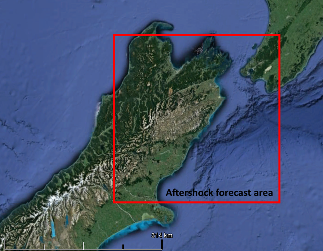
Aftershock forecast area. Credit: GeoNet
The Watchers team and our contributors bring the latest on extreme weather, earthquakes, volcanic eruptions, space weather, and all things science. We're all about making sense of the natural world and keeping you informed on what’s happening. Got a tip or a question? Hit us up using the form at newstips!
I will only say one thing, HAARP .
WHAT EVER MAGNITUDE WHENEVER IT’S REPORTED BY USGS ONE THING IS CERTAIN. THEY WILL AUTOMATICALLY LOWER THE MAGNATUDE FIGURE BY 1full point!!! THAT IS A MANDATE THESE PEOPLE ARE POLITICALLY COMPROMISED.
Surprised by the lack of comments. I am a geologist in Dorset, U.K. fortunately earthquake free not being near a pate boundary. Clearly South Island has a complex of faults and once one moves others will adjust. I have seen some amazing landslide pictures posted by Meryl, a friend who lives in N.Z. Sympathies with those caught up in it.
GNS is lying through their teeth.
They fudge their data. USGS had an accurate result in minutes. Don’t believe the BS – they are hiding much more.