
Hurricane-force winds, extreme rainfall expected in Haiti and Cuba – Hurricane “Matthew”
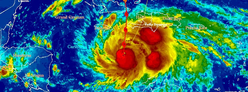
Featured image: Hurricane "Matthew" at 08:45 UTC on October 3, 2016 - IR NHC. Credit: UW-CIMSS
Category 4 Hurricane "Mathew" is moving northward across the central Caribbean Sea toward Haiti, threatening the island with extreme rainfall and hurricane-force winds. Matthew is expected to pass just west or over the western tip of Haiti and hit Cuba's eastern province of Guantanamo as a powerful and extremely dangerous Category 4 hurricane. As it exits Cuba, it will start its dangerous track across the Bahamas as a Category 3 hurricane, toward Florida, Georgia, and the Carolinas, United States.
On the current NHC track (09:00 UTC today), Matthew will pass just north of the western tip of Haiti between 06:00 and 12:00 UTC on Tuesday, October 4, 2016, and make landfall over Guantanamo Province of Cuba around 21:00 UTC.
As it passes between Haiti and Jamaica through its Cuba landfall, Matthew will remain a powerful and extremely dangerous Category 4 hurricane with maximum sustained winds up to 213 km/h (132 mph) and gusts to 259 km/h (161 mph).
Matthew is expected to produce total rain accumulations of 381 to 635 mm (15 to 25 inches) across southern Haiti and the southwestern portion of the Dominican Republic, with possible isolated amounts of 1 016 mm (40 inches).
Across eastern Cuba and western Haiti, total rain accumulations of 203 to 305 mm (8 to 12 inches) are expected with possible isolated maximum amounts of 508 mm (20 inches).
Across eastern Jamaica, total rainfall of 127 to 254 mm (5 to 10 inches) is expected, with isolated maximum amounts of 381 mm (15 inches) possible.
This rainfall will likely produce life-threatening flash floods and mudslides.
Once Matthew moves near the southeastern Bahamas on Wednesday, October 5, it is forecast to turn northwestward or north-northwestward.
The model guidance is in relatively good agreement through 72 hours, but begin to diverge by days 4 and 5, NHC said at 09:00 UTC today.
"Although the official forecast continues to show a track east of Florida, it is still too soon to rule out possible hurricane impacts there. It is also too soon to know whether, or how, Matthew might affect the remainder of the United States east coast."
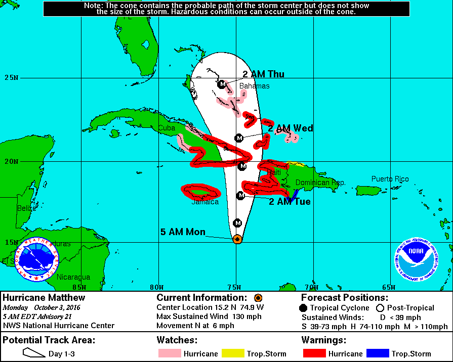
Hurricane "Matthew" forecast track by NHC at 09:00 UTC on October 3, 2016

Hurricane Matthew at 08:45 UTC on October 3, 2016. Credit: UW-CIMSS
Read more: Hurricane "Matthew" summary: data, images and videos – September/October 2016
The Watchers team and our contributors bring the latest on extreme weather, earthquakes, volcanic eruptions, space weather, and all things science. We're all about making sense of the natural world and keeping you informed on what’s happening. Got a tip or a question? Hit us up using the form at newstips!
Commenting rules and guidelines
We value the thoughts and opinions of our readers and welcome healthy discussions on our website. In order to maintain a respectful and positive community, we ask that all commenters follow these rules.