
A new multi-dimensional view of Hurricane “Matthew”
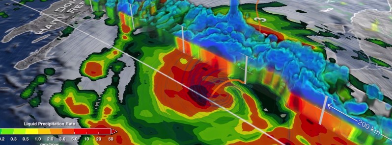
Image credit: NASA's Goddard Space Flight Center/Ryan Fitzgibbons
NASA researchers now can use a combination of satellite observations to re-create multi-dimensional pictures of hurricanes and other major storms in order to study complex atmospheric interactions.
In this video, they applied those techniques to Hurricane Matthew. When it occurred in the fall of 2016, Matthew was the first Category 5 Atlantic hurricane in almost ten years. Its torrential rains and winds caused significant damage and loss of life as it coursed through the Caribbean and up along the southern U.S. coast.
Video courtesy: NASA's Goddard Space Flight Center/Ryan Fitzgibbons
Read more:
Hurricane "Matthew" summary: data, images and videos – September/October 2016
Hurricane "Matthew" makes direct hit on Haiti causing over 1 000 deaths
50 000 without power as Matthew's remnants slam Nova Scotia, Canada
The Watchers team and our contributors bring the latest on extreme weather, earthquakes, volcanic eruptions, space weather, and all things science. We're all about making sense of the natural world and keeping you informed on what’s happening. Got a tip or a question? Hit us up using the form at newstips!
Commenting rules and guidelines
We value the thoughts and opinions of our readers and welcome healthy discussions on our website. In order to maintain a respectful and positive community, we ask that all commenters follow these rules.