
Hurricane “Matthew” pounding Florida
Featured image: Hurricane "Matthew" at 00:45 UTC on October 7, 2016. Credit: UW-CIMSS
Hurricane "Matthew" has left a trail of destruction in Haiti and Cuba, moved over the Bahamas while intensifying into a Category 4 storm and approached the east coast of Florida late on Thursday, October 6, 2016. By 06:00 UTC on October 7, Matthew weakened into a Category 3 hurricane; it was located 70 km (45 miles) E of Vero Beach and 125 km (80 miles) SE of Cape Canaveral, Florida. Some of the outter bands are causing significant trouble.
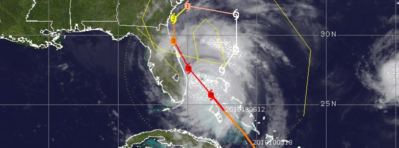
At 06:00 UTC on October 6, Matthew's center was located about 480 km (295 miles) SE of West Palm Beach, Florida and 160 km (100 miles) SSE of Nassau, the capital of Bahamas (population 244 400).
Matthew was moving toward the NW at 17 km/h (10 mph) as a Category 3 hurricane while intensifying.
Its estimated minimum central pressure was 954 hPa.
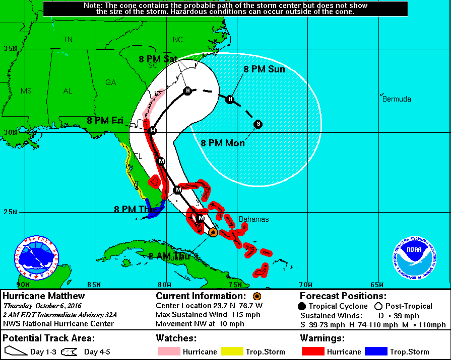
Hurricane Matthew forecast track by NHC at 06:00 UTC on October 6, 2016
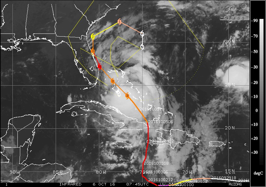
Hurricane "Matthew" at 07:45 UTC on October 6, 2016. Credit: UW-CIMSS
Matthew made a direct hit on Haiti at 11:00 UTC on Tuesday, October 4 near Les Anglais in western Haiti with maximum sustained winds of 230 km/h (145 mph) and gusts to 278 km/h (172 mph).
Haiti is now facing the largest humanitarian event since the devastating M7.0 earthquake of 2010.
Wednesday still didn't show the full extent of the damage as assessments have only just begun because of the weather conditions and lack of access.
According to the information gathered by OCHA/UNDAC during an aerial observation mission, hurricane Matthew has severely affected the south part of Haiti, especially the departments of Grand Anse and South, where the wind produced severe damages. A bridge in the town of Petit Goave has collapsed cutting off road access from Port-au-Prince to the south and preventing fast assistance to the affected communities. As of early October 7, media reports mention over 300 deaths.
Cubans were mostly ready for the storm and there were no reports of casualties, but Matthew destroyed everything in its path after making landfall near the town Juaco around 00:00 UTC on October 5.
The famous town of Baracoa, one of the country's oldest and most historic towns, was hit especially hard with many of the houses destroyed. Initial reports from the city mention complete destruction.
Complete destruction in Baracoa, Cuba from a combination of extreme wind and storm surge. Sad situation here. #HurricaneMatthew pic.twitter.com/JgUtW0vGjf
— Mike Theiss (@MikeTheiss) October 5, 2016
Updates
October 6, 2016
18:27 UTC
Matthew has strengthened into a Category 4 hurricane and passed between Andros Island and New Providence, dangerously close to Nassau, with maximum sustained winds 213 km/h (132 mph).
As of 18:00 UTC, the center of Hurricane "Matthew" was about 205 km (125 miles) ESE of West Palm Beach, Florida and 100 km (62 miles) SSE of Freeport, Bahamas. It had maximum sustained winds of 220 km/h (140 mph) and was moving NW at 22 km/h (14 mph). Its minimum estimated central pressure was 939 hPa.
October 6, 2016
23:47 UTC
At 23:00 UTC, the eye of Category 4 Hurricane "Matthew" was located 135 km (85 miles) ESE of West Palm Beach and 10 km (6.2 miles) S of Freeport, Grand Bahama.
Hurricane Matthew forecast track by NHC at 21:00 UTC on October 6, 2016
Matthew's maximum sustained winds minimum central pressure have not changed; 220 km/h (140 mph) and 939 hPa.
Urgent message from The Weather Channel for those in the path of Hurricane Matthew
Hurricane Matthew could have catastrophic impacts and concerns are growing about people that have decided to stay in areas under mandatory evacuations.
"This is like no storm in the record books. Matthew will make history," Bryan Norcross, Sr. Hurricane Specialist, said.
Haiti
In Haiti, the death toll has risen to 136 people as of late October 6. However, the full scale of destruction is still not known as aid workers are still struggling to reach remote areas of the country.
Marie Alta Jean-Baptiste, the head of the country’s civil protection directorate, warned the death toll was likely to rise.
Aerial footage of the city of Jeremie on the northwestern coast of the country and the capital city of Grand'Anse Department showed hundreds of flattened houses and deserted streets strewn with debris.
Read more: Matthew makes direct hit on Haiti
October 7, 2016
06:33 UTC
At 06:00 UTC the eye of Hurricane "Matthew" was located 70 km (45 miles) E of Vero Beach and 125 km (80 miles) SE of Cape Canaveral, Florida.
Its maximum sustained winds have dropped to 195 km/h (120 mph), making it a Category 3 hurricane again.
Matthew is currently moving to the NW at 22 km/h (14 mph).
A turn toward the north-northwest is expected later today, and a turn toward the north is expected tonight or Saturday. On the forecast track, the center of Matthew will be moving near or over the east coast of the Florida peninsula through tonight, and near or over the coasts of Georgia and South Carolina on Saturday.
Although some additional weakening is forecast during the next 48 hours, Matthew is expected to be a powerful category 3 hurricane as it moves near the coast of Florida.
Outter bands are causing significant trouble along the coast.
At least 175 000 people are already without power.
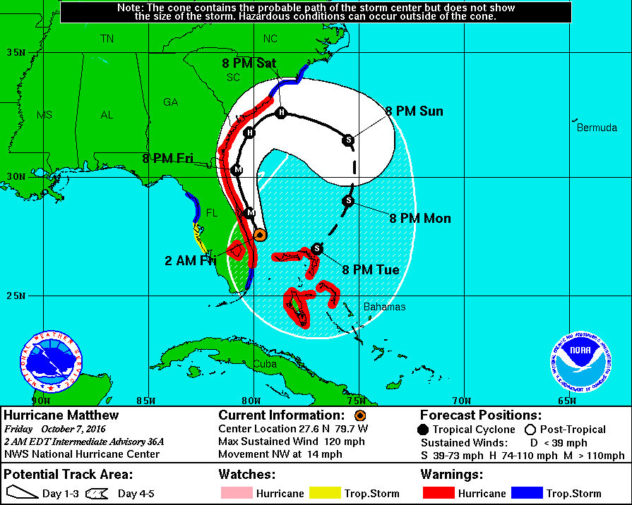
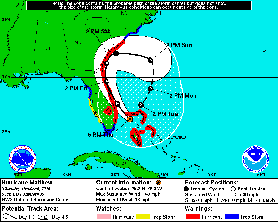
Hurricane "Matthew" forecast track at 06:00 UTC on October 7, 2016
Storm surge
The combination of a dangerous storm surge and large and destructive waves could raise water levels by as much as the following amounts above normal tide levels:
- Northwestern Bahamas: 3 – 4.6 m (10 to 15 feet)
The water could reach the following heights above ground if the peak surge occurs at the time of high tide:
- Sebastian Inlet, Florida, to Edisto Beach, South Carolina, including portions of the St. Johns River: 2.1 to 3.3 m (7 to 11 feet)
- Edisto Beach to South Santee River, South Carolina: 1.2 to 1.8 m (4 to 6 feet)
- Boca Raton to Sebastian Inlet, Florida: 1.2 to 1.8 m (4 to 6 feet)
- South Santee River, South Carolina, to Cape Fear, North Carolina: 0.6 to 1.2 m (2 to 4 feet)
- Virginia Key to Boca Raton, Florida: 0.3 to 0.9 m (1 to 3 feet)
72 hours of rainfall accumulation
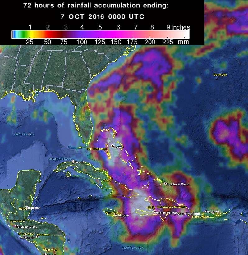
72 hours of rainfall accumulation by 00:00 UTC on October 7, 2016. Credit: NASA/TRMM, Google
Read more: Hurricane "Matthew" summary: data, images and videos – September/October 2016
The Watchers team and our contributors bring the latest on extreme weather, earthquakes, volcanic eruptions, space weather, and all things science. We're all about making sense of the natural world and keeping you informed on what’s happening. Got a tip or a question? Hit us up using the form at newstips!
Commenting rules and guidelines
We value the thoughts and opinions of our readers and welcome healthy discussions on our website. In order to maintain a respectful and positive community, we ask that all commenters follow these rules.