
Powerful eruptions and pyroclastic flows at Mount Sinabung, ash to 6 km a.s.l.
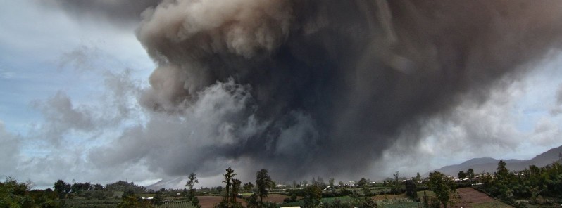
Featured image: Eruption of Mount Sinabung on August 26, 2016. Credit: Nachelle Home Stay (via Facebook)
Mount Sinabung in North Sumatra's Karo District, Indonesia continues to erupt with ash reaching 6 km (20 000 feet) a.s.l. today. As of 05:40 UTC today, the Aviation Colour Code was still on Red.
"The hot clouds are moving towards its previous trajectory – which includes several villages in the district of Namentaran," said the head of Sinabung's Observation Post, Armen Putra to Tempo on Friday, August 26, 2016. Villages that lie along the trajectory of the hot clouds include Bakerah, Simacem, Sukanalu, Sigaranggarang, and Kutagunggung.
Authorities are distributing thousands of masks to communities affected by the eruption.
The Commander of Mount Sinabung's Eruption Taskforce, Lt. Col. Agustatius Sitepu, said that army officers have begun ordering people to leave the red zone. "We will continue to remind and remove any people who have been caught entering the red zone," he said.
Since it was first reported on August 23, 2016, the hot clouds continue to radiate further from the crater – reaching a maximum of 4 km (2.5 miles). Once the dome, which contains some 2.6 million cubic meters of debris, collapses, the hot clouds could reach a distance of 7 km (4.34 miles) from the main crater.
The cause of the current violent phase is likely that the prominent viscous lava lobe that has been spilling over from the summit dome into a steep ravine of the upper flank has now become too unstable and is crumbling apart. During this process, rockfalls can turn into highly mobile and destructive glowing avalanches of disintegrating hot lava rock fragments, gasses released from these and ambient air (so-called pyroclastic density currents / flows), Volcano Discovery reported.
"Current satellite imagery indicates that ash from the volcano has now dissipated. There are no further reports of a new or ongoing eruption," the Darwin VAAC reported at 09:00 UTC today.
Geological summary
Gunung Sinabung is a Pleistocene-to-Holocene stratovolcano with many lava flows on its flanks. The migration of summit vents along a N-S line gives the summit crater complex an elongated form. The youngest crater of this conical, 2 460-m-high (8 070 feet) andesitic-to-dacitic volcano is at the southern end of the four overlapping summit craters.
An unconfirmed eruption was noted in 1881, and solfataric activity was seen at the summit and upper flanks in 1912.
No confirmed historical eruptions were recorded prior to explosive eruptions during August – September 2010 that produced ash plumes to 5 km (16 404 feet) above the summit. (GVP)
The Watchers team and our contributors bring the latest on extreme weather, earthquakes, volcanic eruptions, space weather, and all things science. We're all about making sense of the natural world and keeping you informed on what’s happening. Got a tip or a question? Hit us up using the form at newstips!
Commenting rules and guidelines
We value the thoughts and opinions of our readers and welcome healthy discussions on our website. In order to maintain a respectful and positive community, we ask that all commenters follow these rules.