
New cycle of eruptions closes off Turrialba volcano, Costa Rica
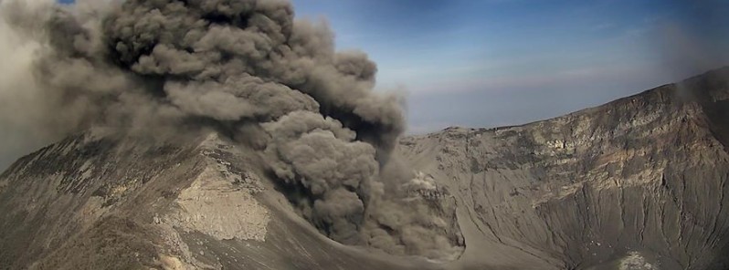
Featured image: Turrialba erupting on May 1, 2016. Credit: RSN
Due to the start of a new cycle of eruptions, access to the Turrialba volcano has been closed off, with a 5-km (3.1 miles) perimeter established, Costa Rica's emergency management office announced on May 1, 2016. After an increase in seismic activity on April 28, the volcano is exhibiting constant activity since April 30.
Between 06:00 and 15:30 (local time) on May 1, the National Seismology Network (RSN) and Vulcanology and Seismology Observatory (OVSICORI), registered 31 eruptions that released gas and ash into the atmosphere.
“After a few weeks of relative calm and with several releases of ash and small, isolated explosions at the start of this year, the Turrialba volcano started a new cycle of eruptions,” RSN volcanologist Raul Mora said.
Authorities warned to stay outside the restricted area around the volcano.
RT @stevenage_tico
Erupción de ceniza del #VolcanTurrialba en estos momentos. Foto Randall Pérez desde #Turrialba pic.twitter.com/8Dk9wpXrFj— Geól. Sergio Almazán (@chematierra) May 2, 2016
If you want to watch Turrialba erupting in real-time, OVSICORI has two high-quality web cameras installed there: camera 1, camera 2.
Geological summary
Turrialba, the easternmost of Costa Rica's Holocene volcanoes, is a large vegetated basaltic-to-dacitic stratovolcano located across a broad saddle NE of Irazú volcano overlooking the city of Cartago. The massive 3340-m-high Turrialba is exceeded in height only by Irazú, covers an area of 500 sq km, and is one of Costa Rica's most voluminous volcanoes.
Three well-defined craters occur at the upper SW end of a broad 800 x 2200 m summit depression that is breached to the NE. Most activity originated from the summit vent complex, but two pyroclastic cones are located on the SW flank. Five major explosive eruptions have occurred during the past 3500 years. A series of explosive eruptions during the 19th century were sometimes accompanied by pyroclastic flows. Fumarolic activity continues at the central and SW summit craters. (GVP)
I'm a dedicated researcher, journalist, and editor at The Watchers. With over 20 years of experience in the media industry, I specialize in hard science news, focusing on extreme weather, seismic and volcanic activity, space weather, and astronomy, including near-Earth objects and planetary defense strategies. You can reach me at teo /at/ watchers.news.
Commenting rules and guidelines
We value the thoughts and opinions of our readers and welcome healthy discussions on our website. In order to maintain a respectful and positive community, we ask that all commenters follow these rules.