
Strong eruptions at Turrialba spew ash over Coronado, Moravia and Guadalupe, Costa Rica
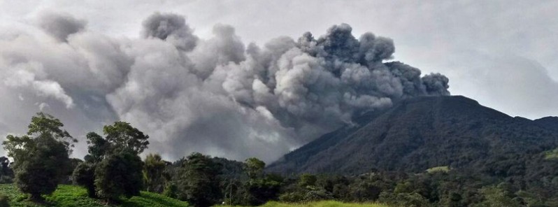
Featured image: Turrialba erupting on May 19, 2016. Credit: CNE
The activity at Costa Rica's Turrialba volcano increased significantly on May 19, 2016, with three strong eruptions and constant ash emissions.
Country's National Seismological Network (RSN) registered the first explosion at 21:46 UTC. The eruption lasted three minutes and generated a pyroclastic flow toward the central crater. A plume of gas and ash reached nearly 1 000 m (3 280 feet) above the crater. The second explosion was recorded at 22:09 UTC. According to RSN, smoke and ash rose to 500 m (1 640 feet) above the crater at about 22:20 UTC and drifted mostly to the southwest. The third explosion, the smallest, was recorded at 23:03 UTC.
The National Emergency Commission (CNE) said ash fall was reported in Coronado, Moravia, and Guadalupe. It recommended taking the necessary forecasts, especially, for those with respiratory problems.
"Ash and other materials from the explosions are visible on various farms located west of the volcano," said CNE geologist Blas Sánchez. He added that ash is accumulating in various nearby rivers.
On May 18, CNE established a 5-km (3.1 miles) restricted access area around the volcano.
Videos of the first eruption – 21:46 UTC on May 19, 2016 (Note: the date at the beginning of the first video is incorrect).
Video taken by CNE geologist Blas Sánchez on May 19, shows ash reaching approximately 200 m (650 feet) above the crater and drifting west.
Turrialba's eruption on Thursday, May 18, preceded by the high level of seismic activity, started at 17:05 UTC and lasted for about three hours, RSN seismologist Mauricio Mora said.
Experts say the volcano can maintain this pattern of eruptive cycles until it rests again without necessarily reaching the scenario of a major eruption like the one in 1864, or that indeed it reached an eruptive stage more similar to that historical eruption.
"These are the two scenarios that may occur, according to scientific opinion of our professionals," RSN said. Therefore, the RSN keeps its researchers constantly monitoring seismic events, collecting samples and observing the overall evolution of the volcano to support operational decisions.
People living nearby are invited to remain aware of the information provided by the RSN through its Facebook and Twitter.
Turrialba camera 1 / camera 2.
Geological summary
Turrialba, the easternmost of Costa Rica's Holocene volcanoes, is a large vegetated basaltic-to-dacitic stratovolcano located across a broad saddle NE of Irazú volcano overlooking the city of Cartago. The massive 3340-m-high Turrialba is exceeded in height only by Irazú, covers an area of 500 sq km, and is one of Costa Rica's most voluminous volcanoes.
Three well-defined craters occur at the upper SW end of a broad 800 x 2200 m summit depression that is breached to the NE. Most activity originated from the summit vent complex, but two pyroclastic cones are located on the SW flank. Five major explosive eruptions have occurred during the past 3500 years. A series of explosive eruptions during the 19th century were sometimes accompanied by pyroclastic flows. Fumarolic activity continues at the central and SW summit craters. (GVP)
The Watchers team and our contributors bring the latest on extreme weather, earthquakes, volcanic eruptions, space weather, and all things science. We're all about making sense of the natural world and keeping you informed on what’s happening. Got a tip or a question? Hit us up using the form at newstips!
Commenting rules and guidelines
We value the thoughts and opinions of our readers and welcome healthy discussions on our website. In order to maintain a respectful and positive community, we ask that all commenters follow these rules.