
Powerful storm causes extreme flash flooding across the US South
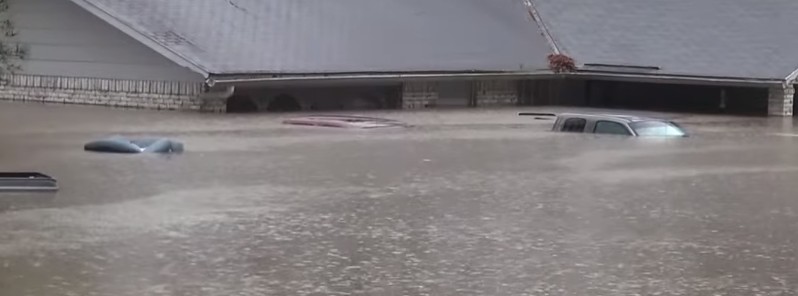
Featured image: Northwest Louisiana flooding on March 9, 2016. Credit: Live Storms Media
A large and anomalous upper-level low is affecting US South as it continues slowly drifting eastward over northern Mexico today. Very heavy rain caused severe flash flooding that claimed lives of three people so far.
"Many locations have experienced extreme flash flooding, particularly across East Texas and Louisiana. Numerous roadways were flooded, and many high-water rescues were performed," NWS Shreveport said. "Homes and businesses were evacuated in many locations, particularly in Haughton and Minden, Louisiana."
With more than 508 mm (20 inches) of rain since Tuesday afternoon, March 8, a historic flash flooding event in Louisiana caused rivers to quickly rise near record flood stages on March 9 and submerge homes. Some areas reported 254 mm (10 inches) of rain in just 10 hours. A state of emergency was declared in 16 Louisiana parishes and National Guard was sent to help with the water rescues.
The hardest hit was Bossier Parish where officials issued a mandatory evacuation order for residents of 3 500 homes.
Wow. The flooding in Bossier Parish, LA. is extreme and devastating – water up to rooftops. @CBSThisMorning pic.twitter.com/1IquXSYOhM
— David Begnaud (@DavidBegnaud) March 9, 2016
In Bienville Parish, a 75-year-old man drowned while trying to drive across flooded road. According to Bienville Sheriff, the current from the raging Saline Creek got hold of the vehicle and pulled in into the water. A 70-year-old woman in the car with him was rescued but was suffering from hypothermia.
Nearly 10 inches of rain were recorded in parts of Texas. According to Weather.com, the impacts in some areas were worse than the catastrophic flooding that occurred in May 2015.
The City of Kilgore, TX has declared a state of emergency, a disaster has been declared in Gregg County after it suffered widespread damage. Since Monday, March 7, six tornadoes were confirmed in Texas. A man was killed Monday night when his kayak capsized as strong storms moved into the Houston area.
In neighboring state of Oklahoma, a 30-year-old man drowned in his car while attempting to cross a bridge covered in floodwaters. His passanger managed to escape.
At least a dozen families had to be evacuated from their homes in Chicot County, Arkansas.
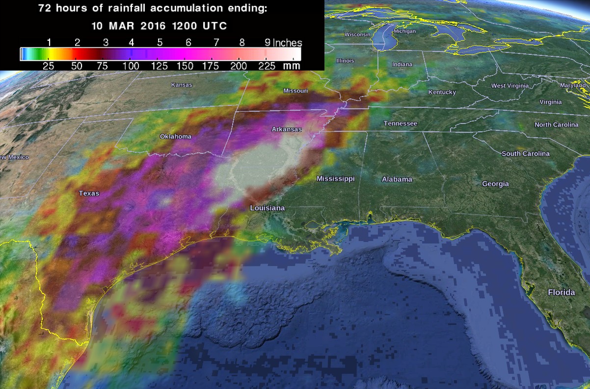
72-hr rainfall accumulation ending 12:00 UTC on March 10, 2016. Credit: NASA/JAXA GPM / Google
More rain expected
This storm system is moving slowly so heavy rain and thunderstorms will continue affecting many of the same areas until Friday, March 11. Heavy rain and threat of flash flooding will continue today for the lower Mississippi valley, NWS said.
Moisture, instability, and upper-level dynamics will be greatest across the lower Mississippi valley and portions of the southern plains, and this is where the potential will continue for very heavy rainfall with the potential for more flash flooding.
The axis of showers and thunderstorms will shift only slightly eastward on Friday, with many of the same areas once again seeing a threat of heavy rain and flash flooding. The plume of showers will extend across the Ohio valley today (March 10) and into the Northeast, ahead of a cold front.
I'm a dedicated researcher, journalist, and editor at The Watchers. With over 20 years of experience in the media industry, I specialize in hard science news, focusing on extreme weather, seismic and volcanic activity, space weather, and astronomy, including near-Earth objects and planetary defense strategies. You can reach me at teo /at/ watchers.news.
Commenting rules and guidelines
We value the thoughts and opinions of our readers and welcome healthy discussions on our website. In order to maintain a respectful and positive community, we ask that all commenters follow these rules.