
Newly formed Tropical Storm “Erika” approaching at a fast pace: The Leeward Islands issue a Tropical Storm Watch
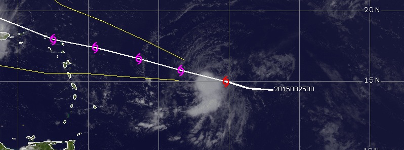
Featured image: Tropical Storm "Erika" on August 25, 2015. Credit: UW-CIMSS.
A newly formed tropical storm in the central tropical Atlantic, named "Erika", is currently approaching the Leeward Islands at a fast pace. As "Erika" is slowly intensifying, a Tropical Storm Watch was issued for the Leeward Islands over the next 48 hours. There is a possibility Erika will affect Puerto Rico, Virgin Islands, Hispaniola, the Bahamas, Cuba and southeast US, however, its movement cannot be precisely predicted yet, and the situation requires further monitoring.
Tropical Storm "Erika" formed over the central tropical Atlantic on August 25, 2015 at 03:00 UTC, about 1 535 km (955 miles) east of the Leeward Islands. It was moving westward at 31 km/h (20 mph), with maximum sustained wind speed estimated at 75 km/h (45 mph) and a minimum central pressure of 1003 hPa.
Tropical Storm Erika forms in the Atlantic, could be hurricane this weekend. http://t.co/tEY5kIgNmm pic.twitter.com/FDomn3pggK
— FOX6 News (@fox6now) August 25, 2015
The system was located 1 170 km (730 miles) east of the Leeward Islands, packing maximum sustained winds of 75 km/h (45 mph) and moving westward at 31 km/h (20 mph), the National Hurricane Center (NHC) reported on August 25, 15:00 UTC. Minimum central pressure was estimated at 1003 hPa, while the wind gust speed reached 93 km/h (58 mph).
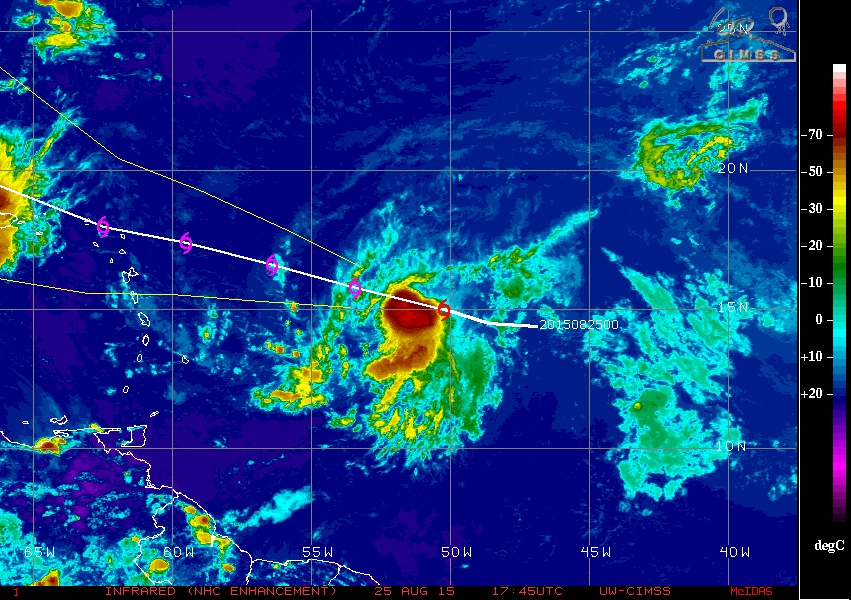
Tropical Storm "Erica" on August 25, 2015. Credit: UW-CIMSS (IR-NHC).
Over the next 48 hours, Erika is expected to move west-northwestward at a slightly lower forward speed. The center of the storm will be near the Leeward Islands on the night of August 26 into the morning of August 27. Maximum sustained wind speeds are expected to remain near 75 km/h (45 mph), although the wind gust speed are likely to increase to about 120 km/h (75 mph).
The most likely path of the Tropical Storm "Erika" over the next 3 days. Image credit: NHC/NOAA.
The tropical storm will slowly strengthen over the next two days, as it will be passing through the moist air mass and low vertical wind shear environment, but its intensity will likely retain a "tropical storm" level, with winds extending up to 130 km (80 miles) from its center.
Tropical Storm force surface winds probability over the next 120 hours, valid from August 25, 2015, at 12:00 UTC. Image credit: NHC/NOAA.
A Tropical Storm Watch over the next 48 hours has been issued for the areas of Montserrat, Antigua and Barbuda, St. Kitts and Nevis, Anguilla, Sabba, St. Eustatius and St. Maarten, Guadeloupe, St. Martin and St. Barthelemy. Over the coming days, additional watches may be required across the areas of Puerto Rico and the Virgin Islands, as the the storm could bring winds and strong rainfall to the drought-stricken areas.
Tropical Storm #Erika potential threat to #Southeast U.S.; latest thoughts on intensity/track: http://t.co/LYZhfE4PMv pic.twitter.com/0Hci5xqac4
— The Weather Channel (@weatherchannel) August 25, 2015
Forecast for #Erika is incredibly uncertain. GFS and Euro are in terrible disagreement. http://t.co/pow94gcozd pic.twitter.com/1B5PNsCtPF
— Capital Weather Gang (@capitalweather) August 25, 2015
It's future movement is hard to precisely forecast for the time being, due to the possibility of a stronger wind sheer and proximity of the dry air mass, as the system approaches the Caribbean.
Tropical Storm #Erika potential threat to #Southeast U.S.; latest thoughts on intensity/track: http://t.co/LYZhfE4PMv pic.twitter.com/0Hci5xqac4
— The Weather Channel (@weatherchannel) August 25, 2015
The progress of the tropical storm will require further attention over the coming days, as its path might progress toward Hispaniola, the Bahamas, Cuba and the southeast US coast.
Commenting rules and guidelines
We value the thoughts and opinions of our readers and welcome healthy discussions on our website. In order to maintain a respectful and positive community, we ask that all commenters follow these rules.