
Typhoon “Nangka” to make landfall on Shikoku island late July 16, Japan

Featured image: Typhoon "Nangka" on July 13, 2015. Image credit: NASA Terra/MODIS.
Tropical depression which later became Super Typhoon "Nangka" was formed on July 3, 2015 north of Marshall Islands, North Pacific Ocean. By July 6 at 06:00 UTC, Nangka reached typhoon strength with maximum sustained winds of 129 km/h (80 mph) and was heading toward Northern Mariana Islands. Latest JTWC forecast points toward direct landfall on Shikoku island late July 16 (UTC) with maximum sustained winds near 167 km/h (103.6 mph).
At 15:00 UTC on July 6, Nangka's center was located about 450 km (278 miles) NW of Ujelang and was moving WNW at 20.3 km/h (12.6 miles).
On July 7, regional warnings were in effect for several areas as Nangka continued moving through the northwestern Pacific Ocean. A typhoon watch was in effect for Agrihan, Pagan and Alamagan in the northern Marianas.
At 15:00 UTC on July 7, Nangka's maximum sustained winds were near 222.2 km/h (138.1 mph) and the storm continued to strengthen. Its center was located about 918 km (570 miles) E of Guam.
On July 8, a Typhoon Warning was in effect for Agrihan, Pagan and Alamagan in the northern Marianas while a Tropical Storm Warning was in force for Saipan and Tinian.
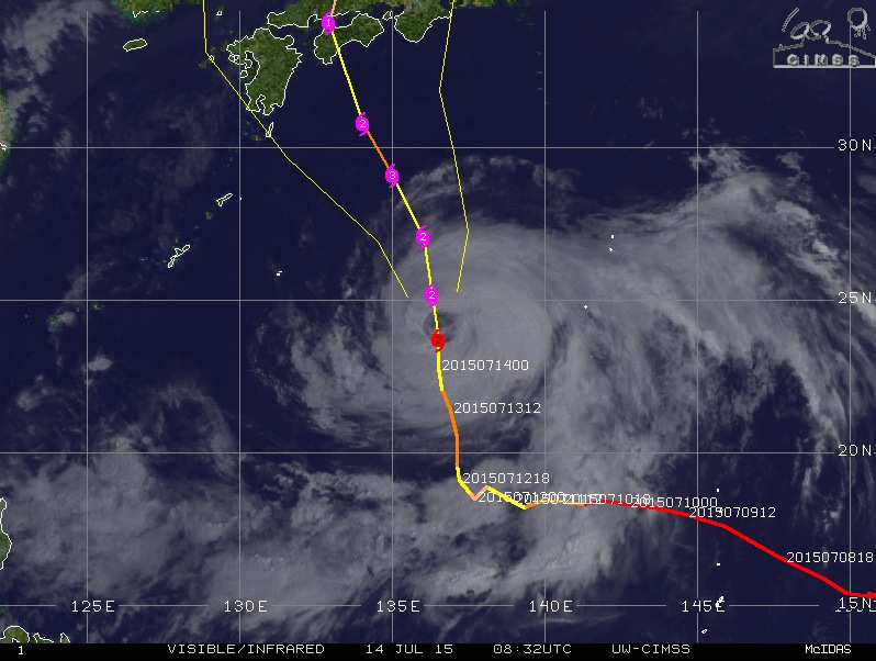
Typhoon "Nangka" forecast track by UW-CIMSS on July 14, 2015.
Early July 9, Nangka reached Super typhoon strength N of Guam and Northern Mariana Islands. Super typhoon is a term utilized by the U.S. Joint Typhoon Warning Center (JTWC) for typhoons that reach maximum sustained 1-minute surface winds of at least 250 km/h (130 kt, 150 mph, 65 m/s). This is the equivalent of a strong Saffir-Simpson category 4 or category 5 hurricane in the Atlantic basin or a category 5 severe tropical cyclone in the Australian basin.
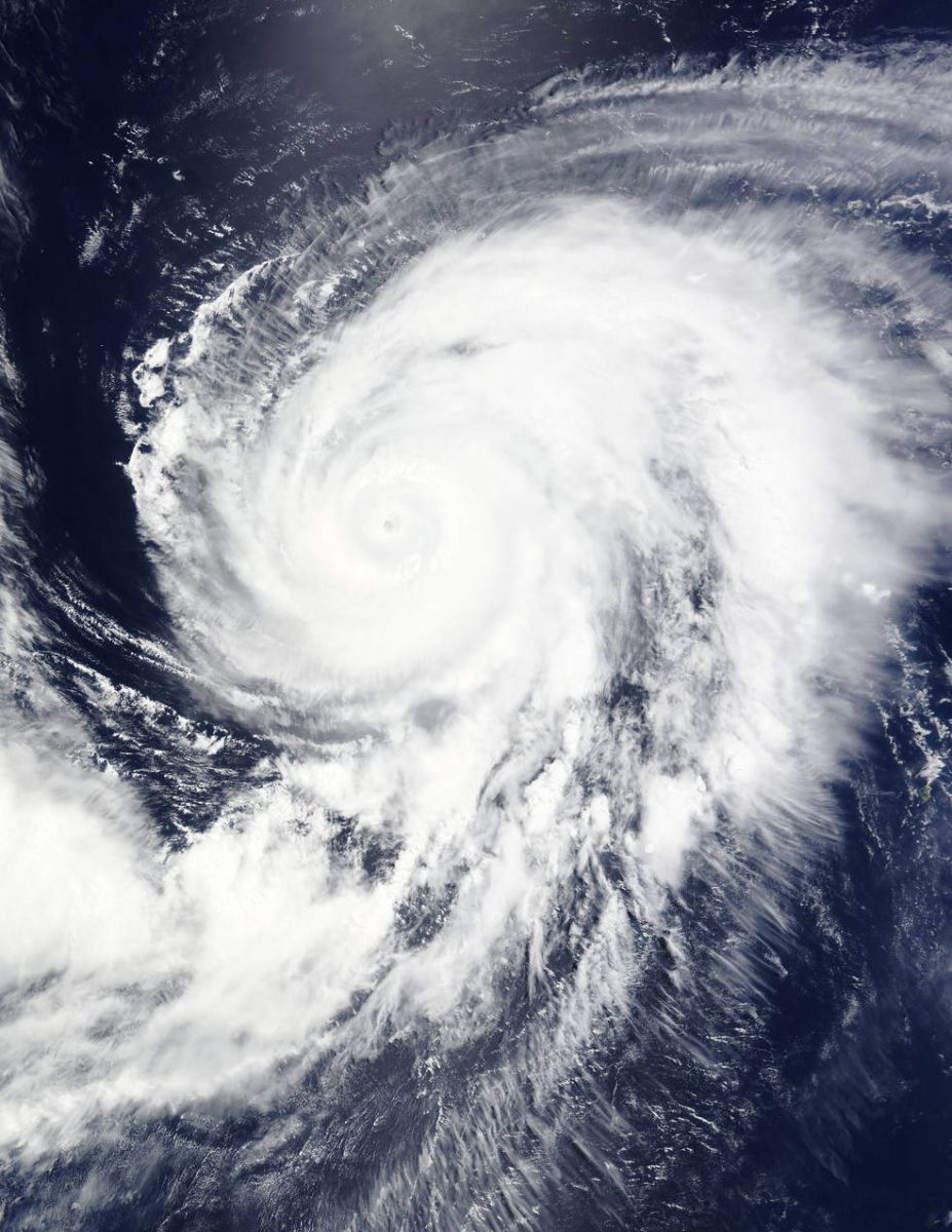
By 15:00 on July 9, its maximum sustained winds dropped to near 203.7 km/h (126.6 mph). Nangka was moving away from Northern Mariana Islands and weakening, but was expected to intensify again on its approach to southern Japan.
Typhoon "Nangka" moving away from Northern Mariana Islands at 01:10 UTC on July 10, 2015. Image credit: NASA Aqua/MODIS.
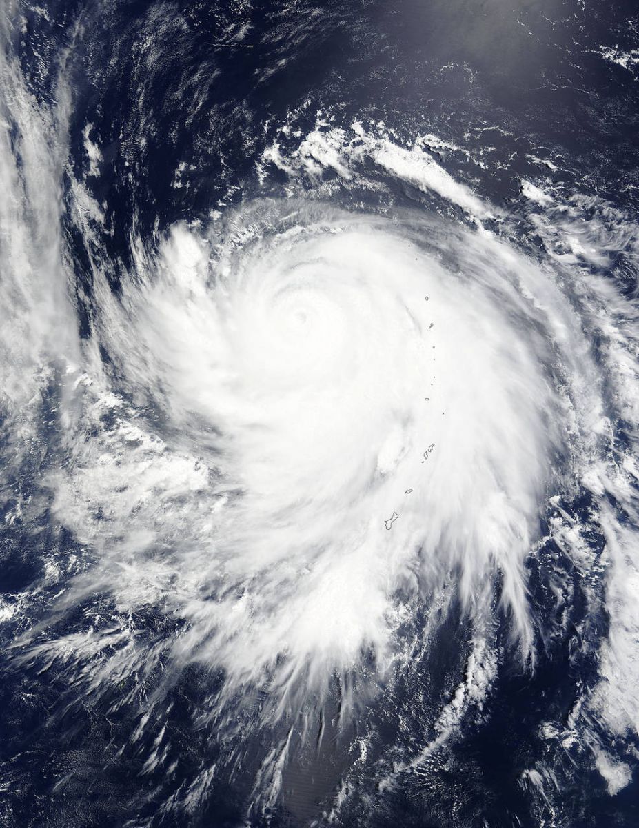
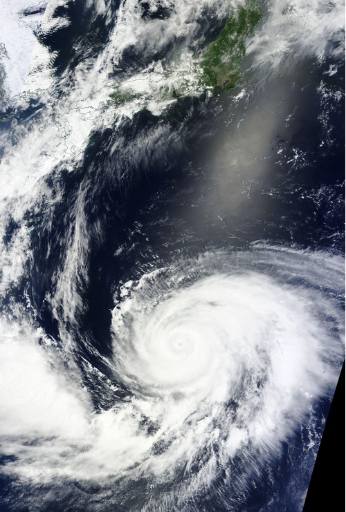
When NASA's Terra satellite passed over Typhoon Nangka on July 13 at 1:40 UTC, the MODIS instrument captured a visible-light image that showed strong bands of thunderstorms spiraling into the center and a visible eye.
Typhoon "Nangka" at 01:40 UTC on July 13, 2015. Image credit: NASA Terra/MODIS.
On July 13 at 15:00 UTC, Nangka's maximum sustained winds were near 194.5 km/h (120.8 mph). The center of the storm was located about 587 km (364 miles) SW of Iwo To, Japan. It was moving NNW at 16.6 km/h (10.3 mph) generating very rough seas with wave heights to 13.7 meters (45 feet).
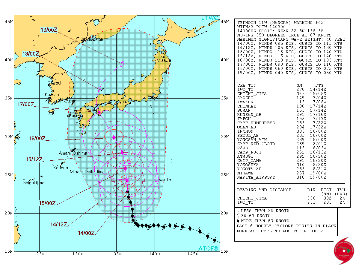
Typhoon "Nangka" forecast track by JTWC on July 14, 2015.
Nangka is expected to near Kyushu, southwestern Japan by July 16. Latest JTWC forecast points toward direct landfall near Iwakuni on Shikoku island late July 16 with maximum sustained winds near 167 km/h (103.6 mph).
Nangka is expected to pass just east of Hiroshima around 06:00 UTC on July 17 and then enter the Sea of Japan.
Typhoon "Nangka" on July 13, 2015. Image credit: NASA Terra/MODIS.
Satellite animations
- Storm-Centered Infrared (MTSAT; NOAA/SSD)
- Storm-Centered Infrared (Aviation Color Enhancement) (MTSAT; NOAA/SSD)
- Storm-Centered Water Vapor (MTSAT; NOAA/SSD)
- Storm-Centered Visible (MTSAT; NOAA/SSD)
- Storm-Centered Visible (Colorized) (MTSAT; NOAA/SSD)
- Storm-Centered Infrared (MTSAT2; CIMSS)
- Storm-Centered Enhanced Infrared (MTSAT2; CIMSS)
- Storm-Centered Water Vapor (MTSAT2; CIMSS)
- Storm-Centered Visible (MTSAT2; CIMSS)
- Tropical West Pacific Infrared (MTSAT2; NOAA)
- Tropical West Pacific Enhanced Infrared (MTSAT2; NOAA)
- Tropical West Pacific Water Vapor (MTSAT2; NOAA)
- Tropical West Pacific Visible (MTSAT2; NOAA)
I'm a dedicated researcher, journalist, and editor at The Watchers. With over 20 years of experience in the media industry, I specialize in hard science news, focusing on extreme weather, seismic and volcanic activity, space weather, and astronomy, including near-Earth objects and planetary defense strategies. You can reach me at teo /at/ watchers.news.
Commenting rules and guidelines
We value the thoughts and opinions of our readers and welcome healthy discussions on our website. In order to maintain a respectful and positive community, we ask that all commenters follow these rules.