
Strong eruption of Turrialba prompts evacuations, causes flight disruptions, Costa Rica
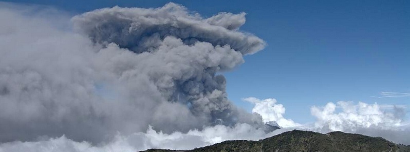
Featured image: Turrialba eruption on March 12, 2015. Image credit: OVSICORI-UNA
A new strong eruption of Costa Rica's Turrialba volcano started around 16:50 UTC on March 12, 2015. Volcanic material reached some 500 meters above the summit. This is the second major eruption of this volcano in the last five years.
Raúl Mora, volcanologist with the National Seismological Network, said a series of volcanic tremors in the surroundings of Turrialba canton followed the explosion. He added the explosion had a greater magnitude than those recorded last weekend.
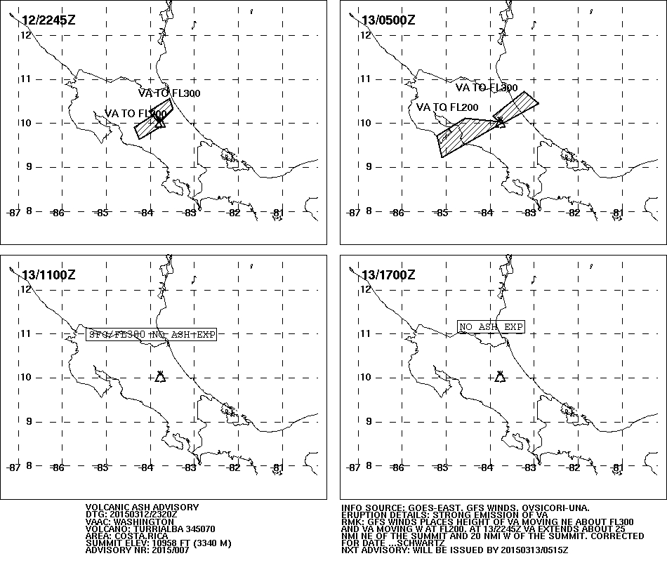
At 23:20 UTC on March 12, Washington VAAC reported strong emission of volcanic ash. "GFS winds places height of volcanic ash moving NE about 9.1 km (FL300) and volcanic ash moving W at 6 km (FL200). At 22:45 UTC volcanic ash extends about 46 km NE of the summit and 30 km W of the summit".
Emergency services ordered the closure of access roads near the volcano and started evacuating a radius of about 1.6 km (1 mile) around the volcano.
Ash reached parts of the capital San Jose located some 67 km (41 miles) to the SSW and closed the country’s Juan Santamaría International Airport.
Volcanological and Seismological Observatory of Costa Rica (OVSICORI-UNA) said ashes were visible on roofs, windows and cars as far as the provinces of San José and Heredia.
In their Volcanic Ash Advisory issued 05:15 UTC on March 13, Washington VAAC reported volcanic ash was not identifiable from satellite data and there have been no more additional reports of activity.
Incredible picture of the #Turrialba #Volcano erupting in Costa Rica #VolcánTurrialba (via @nacion) pic.twitter.com/Pxii3elDgI
— Brian Lada (@wxlada) March 13, 2015
Hoy entró en fase eruptiva el Volcán #Turrialba #CostaRica La ceniza obligó cierre del aeropuerto. Foto vía @nacion pic.twitter.com/KkYkwjBtLS
— Geól. Sergio Almazán (@chematierra) March 13, 2015
En Costa Rica, tras una serie de erupciones volcán #Turrialba genera lluvia de ceniza http://t.co/sW1QiMS4iC pic.twitter.com/ToIR1y2akV
— TABASCO HOY (@TabascoHOY) March 13, 2015
The last eruptive phase of this volcano started on January 5, 2010 and ended around March 7, 2010 (VEI 2). Before that, Turrialba was quiet for 144 years.
Geologic summary
Turrialba, the easternmost of Costa Rica's Holocene volcanoes, is a large vegetated basaltic-to-dacitic stratovolcano located across a broad saddle NE of Irazú volcano overlooking the city of Cartago. The massive 3340-m-high Turrialba is exceeded in height only by Irazú, covers an area of 500 sq km, and is one of Costa Rica's most voluminous volcanoes. Three well-defined craters occur at the upper SW end of a broad 800 x 2200 m summit depression that is breached to the NE.
Most activity originated from the summit vent complex, but two pyroclastic cones are located on the SW flank. Five major explosive eruptions have occurred during the past 3500 years. A series of explosive eruptions during the 19th century were sometimes accompanied by pyroclastic flows. Fumarolic activity continues at the central and SW summit craters. (GVP)
I'm a dedicated researcher, journalist, and editor at The Watchers. With over 20 years of experience in the media industry, I specialize in hard science news, focusing on extreme weather, seismic and volcanic activity, space weather, and astronomy, including near-Earth objects and planetary defense strategies. You can reach me at teo /at/ watchers.news.
Villarrica:https://youtu.be/6VjDpz4wkSw