
Tropical Cyclone “Niko” formed over the South Pacific Ocean
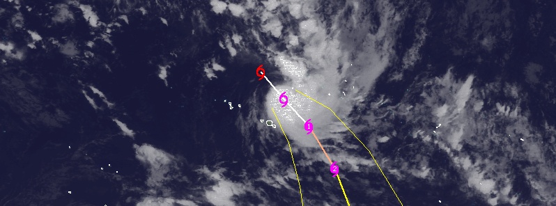
Image credit: UW CIMSS
Tropical Cyclone "Niko" formed over the South Pacific Ocean late Tuesday, January 20, 2015 approximately 580 km (360 miles) northwest of Tahiti Island, French Polynesia and has gradually intensified.
Niko is Summer's first South Pacific tropical cyclone, New Zealand's Stuff writes. The season, which begins in October each year, has been one of the quietest on record.
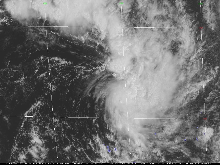
Tropical Cyclone "Niko" at 20:22 UTC on January 20, 2015. Image credit: UW CIMSS
RSMC Nadi Tropical Warning Centre is predicting strong winds and rains for Papeete, the capital of Tahiti.
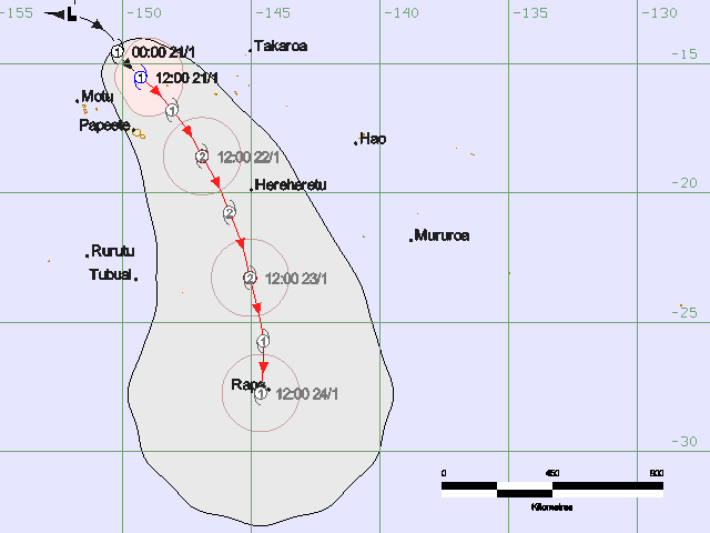
Tropical Cyclone "Niko" forecast track by RSMC Nadi on January 21, 2015
According to JTWC warning issued 09:00 UTC today, Niko was located approximately 279 km (173 miles) N of Papeete, Tahiti and has tracked SSE at 12.9 km/h (8 mph) over the past six hours. The initial intensity remains at 83 km/h (51.7 miles), the agency said.
Upper level analysis indicates Niko is located in an area of low to moderate vertical wind shear (vws) and excellent poleward outflow. The cyclone is currently tracking under the steering influence of a near-equatorial ridge to the SW.
During the next 36 hours, Niko is forecast to track SE as the steering transitions to a sub-tropical ridge to the east.
Favorable environmental and upper-level conditions are expected to persist allowing Tropical Cyclone "Niko" to further intensify to a peak of 157 km/h (97 mph). This would be equivalent of a Category 2 hurricane of the Saffir Simpson Hurricane Wind Scale.
After 48 hours, Niko is expected to turn SW and begin to weaken as vws increases. The combined effect of a stronger vws and coller sea surface temperatures will rapidly decay the system leading to dissipation during January 25.
Maximum significant wave height at 06:00 UTC today was 3.6 meters (12 feet).
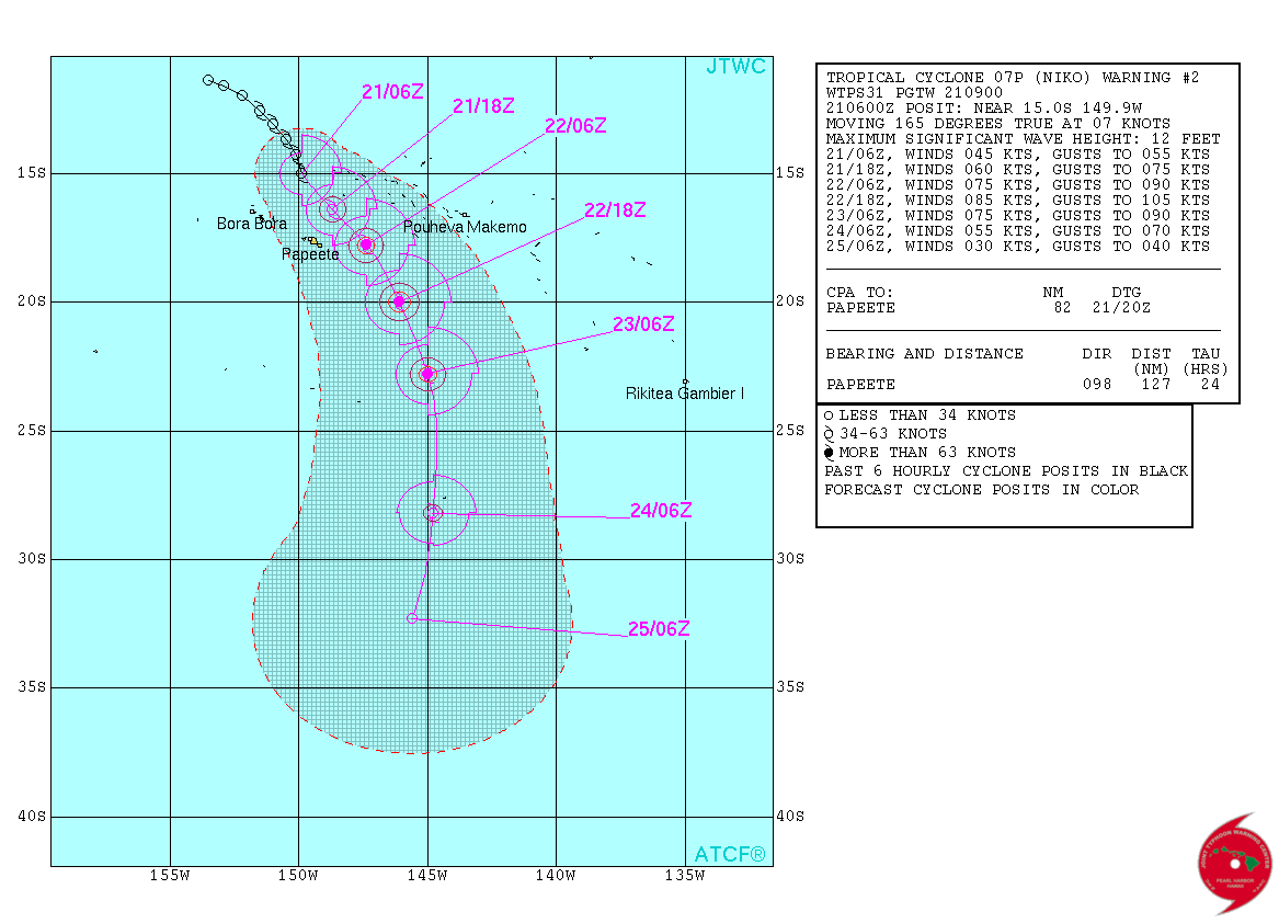
Tropical Cyclone "Niko" forecast track by JTWC on January 21, 2015
Tropical storm force winds are expected to impact the French Polynesian island of Bass early January 24, 2015 (UTC).
Satellite animations
- Storm-Centered Infrared (GOES 15; NOAA/SSD)
- Storm-Centered Infrared (Aviation Color Enhancement) (GOES 15; NOAA/SSD)
- Storm-Centered Water Vapor (GOES 15; NOAA/SSD)
- Storm-Centered Visible (GOES 15; NOAA/SSD)
- Storm-Centered Visible (Colorized) (GOES 15; NOAA/SSD)
- Storm-Centered Infrared (GOES 15; CIMSS)
- Storm-Centered Enhanced Infrared (GOES 15; CIMSS)
- Storm-Centered Water Vapor (GOES 15; CIMSS)
- Storm-Centered Visible (GOES 15; CIMSS)
- Southeast Pacific Infrared (GOES 15; NOAA)
- Southeast Pacific Enhanced Infrared (GOES 15; NOAA)
- Southeast Pacific Water Vapor (GOES 15; NOAA)
I'm a dedicated researcher, journalist, and editor at The Watchers. With over 20 years of experience in the media industry, I specialize in hard science news, focusing on extreme weather, seismic and volcanic activity, space weather, and astronomy, including near-Earth objects and planetary defense strategies. You can reach me at teo /at/ watchers.news.
Commenting rules and guidelines
We value the thoughts and opinions of our readers and welcome healthy discussions on our website. In order to maintain a respectful and positive community, we ask that all commenters follow these rules.