
Winter storm system, cold surge developing southwest of Japan
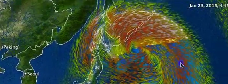
Image credit: WestPacWx
Remnants of Tropical Storm "Mekkhala" and a developing mid-latitude low pressure area over East China Sea are expected to join through Thursday, January 22 just south of Japan.
The system will slide parallel to the eastern coast of Japan bringing wide spread rain, snow and some thunderstorms across Japan, meteorologist Robert Speta of the WestPacWx said.
As the low tracks NE it will gather moisture from the warm Kurushio current ushering in wide spread rainfall for the pacific coast of Japan including Tokyo starting Wednesday night through Thursday. Thunderstorms will also be likely along the front line with snowfall occurring farther inland.
Gale force winds will be seen near the coast with the low but as it tracks north east winds will start to switch from the North West ushering in cold Siberian air across the region.
When this low gets up to eastern portions of Hokkaido there it is going to be a "beast" of a storm, Speta warned. Tropical storm equivalent winds are expected all the way from Kuril Islands over through Hokkaido which is going to wrap up to bring heavy snow.
Video courtesy of WestPacWx
The Watchers team and our contributors bring the latest on extreme weather, earthquakes, volcanic eruptions, space weather, and all things science. We're all about making sense of the natural world and keeping you informed on what’s happening. Got a tip or a question? Hit us up using the form at newstips!
Commenting rules and guidelines
We value the thoughts and opinions of our readers and welcome healthy discussions on our website. In order to maintain a respectful and positive community, we ask that all commenters follow these rules.