
Biggest storm in nearly a decade to affect Northern California and Oregon, US
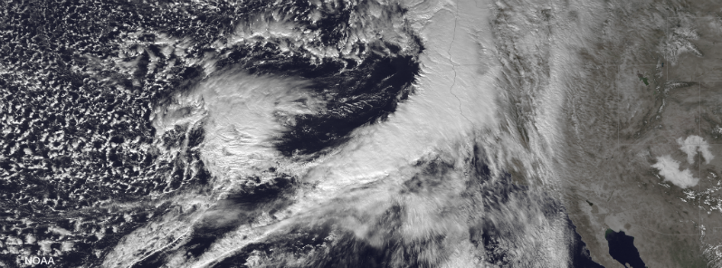
Featured image: GOES West satellite image taken at 21:00 UTC on December 10, 2014. (Credit: NOAA/GOES)
Biggest Pacific storm system in nearly a decade is about to bring flooding and mudslide danger for Northern California and Oregon. An atmospheric river of moisture, also known as "Pineapple Express", is tapping moisture from the tropics ahead of round of storms that are flowing over the Pacific Ocean and into the West Coast of the United States.

GOES WEST satellite images taken from 21:30-22:30 UTC on December 10, 2014. (Credit: NOAA/McIDADS/UW-CIMSS)

GOES WEST Rainbow IR satellite images taken at 22:30 UTC on December 10, 2014. (Credit: NOAA/GOES)

MIMIC total precipitation model for December 10, 2014. (Credit: NOAA/CIMSS/TPW)
The system will also bring strong winds with gusts strong enough to down trees and cause power outages and travel disruption along the coast and over the hills and mountains from western Washington state to central California. Powerful gusts are forecast to affect San Francisco, Portland, Oregon, Seattle-Tacoma, Washington area during late December 11, 2014. Wind gusts can reach speed between 80 – 120 km/h (50 – 75 mph) around the coast of northern California and Oregon, which is bordering hurricane force wind speed. High winds on the Sierra ridges is expected to reach speed to well over 160 km/h (100 mph) with local gusts to 210 km/h (130 mph).

Jet stream forecast and GFS forecast model for December 11, 2014. (Credit: SFSU/GFS)
On December 12, storm system will deliver millions of gallons of water per square miles on drought-affected areas across California. Despite of much needed drought relief, the high risk of flash floods and mudslides will be dominant, especially in poor drainage areas and recent burn areas.

Total precipitation quantitative forecast for December 11 and 12, 2014. (Credit: NOAA/NWS/NCEP/WPC)

Precipitation amounts forecast for December 12, 2014. (Credit: NOAA/NWS/NCEP/WPC)
Rounds of heavy rainfall with amounts of 50-100 mm (2 to 4 inches). As of early December 11, 2014, coastal flood warnings are in effect for South Central Oregon Coast and Curry County Coast. Flood warnings are in effect in state of California for Eureka and Sacramento areas and flood watches for San Francisco Bay Area, Monterrey, San Joaquin Valley, Los Angeles and San Diego areas.
Snowfall amounts of 30 – 90 cm (1-3 feet) can be expected for the Sierra Nevada and the northern California mountains.

Published in the last 24 hours
- High Risk of excessive rainfall covers Florida’s Space Coast as St. Johns River near Cocoa reaches 5.67 m
- Asteroid 2026 WJ to pass Earth at 1.7 lunar distances at 04:20 UTC on November 22, with 2026 WD following at 4.4 lunar distances on November 23
- Cyclone Akvan crossed the north Andhra Pradesh and south Odisha coasts close to Gopalpur on November 20 with 70-80 km/h winds gusting to 90, and has weakened into a deep depression
- A broad low over southeastern Florida and the northwestern Bahamas has a 30 percent chance of subtropical or tropical development within 48 hours and a 50 percent chance within 7 days, the National Hurricane Center says
