
Manuel re-intensified to hurricane strength, expected to make landfall again
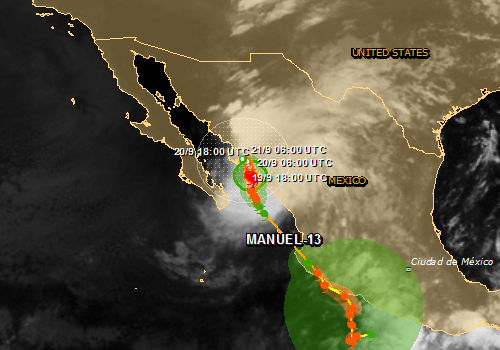
Image credit: Hurricane Manuel cloud map. The map shows the areas affected by tropical storm strength winds (green), 58mph winds (orange) and cyclone wind strengths (red). (Source: JRC)
Two tropical storms, Ingrid and Manuel, brought heavy rainfall and caused destruction and chaos throughout Mexico over the last couple of days. Current estimates are that 80 people have been killed. The forecasters are warning of more storms ahead as Manuel re-intensified to hurricane strength in the last few hours and is expected to make landfall again. Tens of thousands of people have been trapped in massive landslides.
Manuel first hit Mexico as tropical storm on Sunday, September 15, and intensified to hurricane strength on Wednesday, calmed down and re-intensified on Thursday.
On Monday, September 16, a major landslide hit small village of La Pintada in the country's southern mountains. Mexican president Enrique Peña Nieto said that at least 58 people are missing in the village, which has a population of about 400 people. He described the damage there as "catastrophic." It's unclear how many people remain buried, he said.
More than half of La Pintada was demolished, few homes were left,” Maria del Carmen Catalan, a 27-year-old mother of three, said at a convention center that serves as a refuge for storm victims (GP).
Looting has broken out in the flooded Mexican beach resort of Acapulco as the government struggled to reach people cut off by flooding.
More than one million people have been affected and Acapulco's airport terminal was under water, stranding tourists.
Dozens of homes in Tampico, one of the main Gulf ports north of Veracruz, were waterlogged when the Panuco River burst its banks, forcing evacuations.
.png)
Hurricane Manuel cloud map. The map shows the areas affected by tropical storm strength winds (green), 58mph winds (orange) and cyclone wind strengths (red). (Source: JRC)
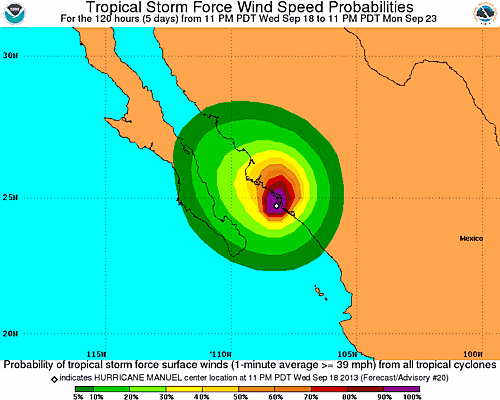
Hurricane Manuel – Wind speed probabilities. Source: NOAA – NWS – NHC
NOAA's National Hurricane Center said the center of Manuel is expected to gradually move a small distance inland over western Mexico in the next 24 hours and weaken in next 48 hours.
It is expected to produce 13 – 25 cm (5 – 10 inches) of rain over the Mexican state of Sinaloa, with isolated maximum amounts of 38 cm (15 inches) possible.
The rain could produce life-threatening flash floods and mud slides.
Manuel is also expected to produce additional 2.5 – 5 cm (1 to 2 inches) of rain over the southern portion of the Baja California and the state of Nayarit.
A dangerous storm surge will raise water levels by as much as 61 – 122 cm (2 to 4 feet) above normal tide levels along the immediate coast near and to the south of where the center makes landfall. Near the coast, the surge will be accompanied by large and destructive waves.
Meanwhile, a new tropical system formed in the south-east producing disorganized shower and thunderstorm activity, although forecasters do not yet know if it is likely to roll into Mexico along a similar path to Ingrid, or perhaps head north to Texas or Louisiana in the US.
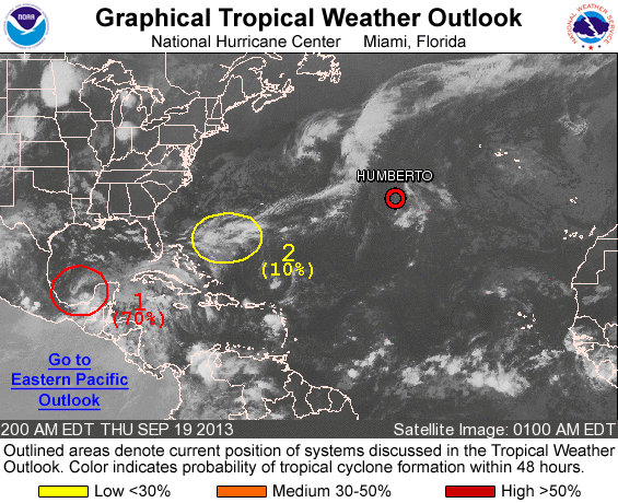
New tropical system formed in the south-east. Source: NOAA – NWS – NHC
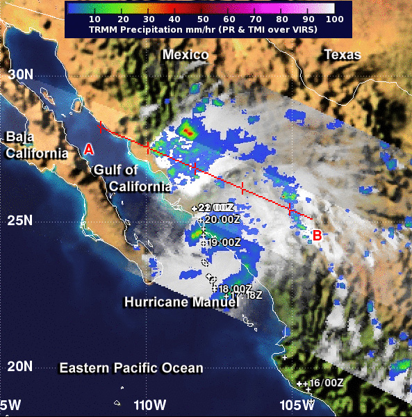
Image credit: NASA TRMM
Update: NASA's TRMM satellite passed over Manuel on September 19 at 01:16 UTC and measured its rainfall as it was strengthening into a hurricane TRMM noticed heavy rainfall and some hot towering thunderstorms, which were indications that the storm was intensifying.
A "hot tower" is a tall cumulonimbus cloud that reaches at least to the top of the troposphere, the lowest layer of the atmosphere. It extends approximately 9 miles/14.5 km high in the tropics. The hot towers in Manuel were over 9.9 miles/16 km high. These towers are called "hot" because they rise to such altitude due to the large amount of latent heat. Water vapor releases this latent heat as it condenses into liquid. NASA research shows that a tropical cyclone with a hot tower in its eyewall was twice as likely to intensify within six or more hours, than a cyclone that lacked a hot tower. When TRMM passed over Manuel and captured the hot towers, it was just about one hour after the National Hurricane Center classified the storm as a hurricane.
NASA's Aqua satellite captured an infrared image that showed Manuel was making landfall during the morning of September 19, and at 15:00 UTC Hurricane Manuel officially made landfall near Culican, Mexico.
At 15:00 UTC Manuel's maximum sustained winds were near 75 mph/120 km/h when its center came ashore in Culiacan, Mexico. It was near 25.0 north and 107.8 west. Manuel is moving north near 3 mph/ 6 km/h and is expected to turn to the north-northeast is expected later today. The NHC expects Manuel to weaken to a tropical depression late tonight or early Friday, September 20, finally dissipating over the mountains of Mexico late on September 20.
I'm a dedicated researcher, journalist, and editor at The Watchers. With over 20 years of experience in the media industry, I specialize in hard science news, focusing on extreme weather, seismic and volcanic activity, space weather, and astronomy, including near-Earth objects and planetary defense strategies. You can reach me at teo /at/ watchers.news.
Commenting rules and guidelines
We value the thoughts and opinions of our readers and welcome healthy discussions on our website. In order to maintain a respectful and positive community, we ask that all commenters follow these rules.