
Tropical Storm Cosme likely to become hurricane in the next 24 hours
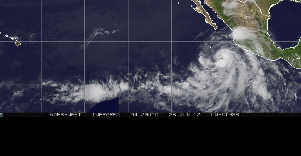
Featured image: Infrared visible satellite image of East Pacific at 04:30 UTC on June 25, 2013 (Credit: NASA GOES/CIMSS/UW/SSEC)
Tropical Depression 3-E took shape on June 23, 2013 about 500 miles south of Manzanillo, Mexico, in the eastern Pacific Ocean, and strengthened into Tropical Storm Cosme early on June 24, 2013.
According to latest public advisory issued by US National Hurricane Center (NHC) at 3:00 UTC on June 24, 2013, the center of Tropical Storm Cosme was located near latitude 15.9 north and longitude 107.9 west, about 320 miles (515 km) SW of Manzanillo, Mexico. Maximum sustained winds have increased to near 65 mph (100 km/h.) with higher gusts. Additional strengthening is forecasted and Cosme is expected to become a hurricane on June 25, 2013. Tropical storm force winds extend outward up to 175 miles (280 km) from the center. The estimated minimum central pressure is 994 mb (29.35 inches). Cosme is moving northwestward near 14 mph (22 km/h).
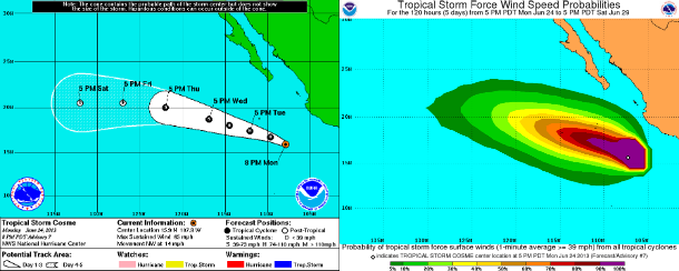
Five day forecast and tropical storm force wind speed probabilities maps (Credit: NOAA/NHC)
A turn toward the west-northwest is expected during June 25, 2013 and this motion should continue through the next 48 hours. The environment around the tropical cyclone should be conducive for continued intensification for the next 24 hours. After that, the cyclone should quickly weaken as it enters into much colder waters.
Cosme is forecasted to become a remnant low after the next 96 hours. Cosme continues to move northwestward along the southwestern periphery of a mid-level ridge over northern Mexico and the southwestern United States. According to NHC, while the ridge builds during next 24 hours, Cosme should turn toward the west-northwest and remain on that heading for several days. Beyond 72 hours, the low-level remnants of Cosme are expected to move westward, following the low-level trade winds.
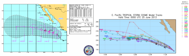
Tropical Storm Cosme forecast tracks (Credit: JTWC/UWM)
Surfs and swells generated by Cosme are affecting portions of the Pacific coast of Mexico from near Manzanillo through Cabo Corrientes. These swells are likely to cause dangerous surf and rip current conditions.
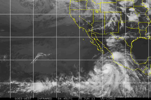
GOES West Infrared satellite image of TS Cosmo at 04:45 UTC on June 25, 2013 (Credit: NASA GOES/CIMSS)
Satellite Animations
- Storm-Centered Infrared (GOES 15; NOAA/SSD)
- Storm-Centered Infrared (Aviation Color Enhancement) (GOES 15; NOAA/SSD)
- Storm-Centered Water Vapor (GOES 15; NOAA/SSD)
- Storm-Centered Visible (GOES 15; NOAA/SSD)
- Storm-Centered Visible (Colorized) (GOES 15; NOAA/SSD)
- East Pacific Infrared (GOES 15; NOAA/SSD)
- East Pacific (Aviation Color Enhancement) (GOES 15; NOAA/SSD)
- East Pacific Water Vapor (GOES 15; NOAA/SSD)
- East Pacific Visible (GOES 15; NOAA/SSD)
- East Pacific Visible (Colorized) (GOES 15; NOAA/SSD)
Commenting rules and guidelines
We value the thoughts and opinions of our readers and welcome healthy discussions on our website. In order to maintain a respectful and positive community, we ask that all commenters follow these rules.