
Green: Vegetation on planet Earth
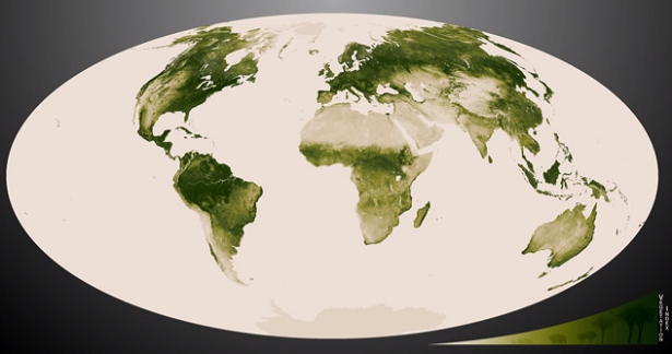
Featured image: Green vegetation index - Flat Earth (Credit: NASA/NOAA)
Although 75% of the planet is a relatively unchanging ocean of blue, the remaining 25% of Earth's surface is a dynamic green. NASA/NOAA Suomi NPP satellite is able to detect these subtle differences in greenness. Those resources highlight our ever-changing planet, using highly detailed vegetation index data from the satellite, developed by scientists at NOAA.
The darkest green areas are the lushest in vegetation, while the pale colors are areas sparse in vegetation coverd either with snow, rock, effected by drought or urban areas. Satellite data from April 2012 to April 2013 was used to generate incredible animations and images.
Vegetation changes are seen to subtlety alter over one year in videos below, using vegetation index data from the NASA/NOAA Suomi NPP satellite.


Amidst the deserts of Egypt, the Nile River provides life-sustaining water to the region. Also visible are the urbanized areas of northern Egypt.(Credit: NASA/NOAA)

Moisture from the Caspian Sea precipitates on the northern edge of the Elburz Mountains, and on the southern edge, deserts emerge in the rain shadow.(Credit: NASA/NOAA)

The "river of grass" extending south of Lake Okeechobee shows clear signs of its modified state with areas of dense agriculture, urban sprawl and water conservation areas delineated by a series of waterways that crisscross Southern Florida. (Credit: NASA/NOAA)
You can view, download, or analyze more of this data from NASA Earth Observations (NEO): Vegetation
Source: NOAA Environmental Visualisation Laboratory

Earlier reporting
Nothing on Watchers was published in the last 24 hours. These are older articles.
- On October 22, 2017, a single flash of lightning stretched 515 miles from eastern Texas to near Kansas City, a distance that takes eight hours to drive, and nobody realized how far it had gone until scientists went back through the satellite data years later Epicenter
- CPC posts a slight risk of heavy rain from the Gulf Coast to the Northeast urban corridor November 25-29, and a moderate risk of West Coast wind and Sierra snow on November 25
- Florida's east coast faces a moderate flash flood risk Wednesday through Friday, with 4 to 8 inches of rain forecast and the St. Johns River near Cocoa already in major flood at 17.13 feet
- Cyclone Akvan to make landfall between Nellore and Visakhapatnam around noon on November 20, IMD forecasts 120-130 km/h winds gusting to 145
