
Bedmap2 – detailed view of Antarctica’s landmass
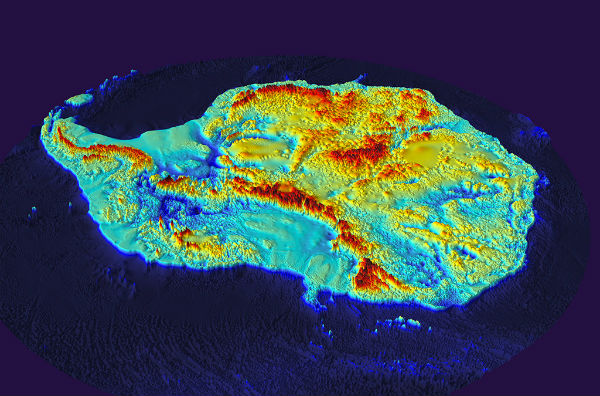
Featured image: Antarctica without the ice (Credit: BAS(BEDMAP consortium)
Scientists at the British Antarctic Survey (BAS) have released the most detailed map yet of Antarctica’s landmass that allows scientists to better analyse the bed below the Antarctic ice sheet.
Bedmap2 reveals a landscape of mountain ranges and plains cut by gorges and valleys much deeper than previously seen. BEDMAP is a close-up view of the landscape beneath the Antarctic ice sheet and incorporates decades of survey data acquired by planes, satellites, ships and even researchers on dog-drawn sleds.

The map was compiled using datasets collected from radio echo sounding measurements, seismic techniques, satellite readings and cartographic data. Some of the highlights include new key statistics – the volume of ice in Antarctica is 4.6% greater than previously thought and the mean bed depth of Antarctica, at 95 meters, is 60 m lower than estimated.
Also, the volume of ice that is grounded with a bed below sea level is 23% greater than originally thought meaning there is a larger volume of ice that is susceptible to rapid melting. The ice that rests just below sea level is vulnerable to warming from ocean currents.

Points of interest which are mentioned in the paper (Credit: BAS/NERC)
The total potential contribution to global sea level rise from Antarctica is 58 metres, similar to previous estimates but a much more accurate measurement. The new deepest point, under Byrd Glacier, is around 400 metres deeper than the previously identified deepest point. (Courtesy of BAS/BEDMAP consortium)

Thickness of ice above land (left) and elevation (right) (Credit: BAS/NERC)
Source: British Antarctic Survey (BAS)

Published in the last 24 hours
- Male toads abandoned a pond in Italy five days before a deadly 2009 earthquake, while a scientist was counting them Epicenter
- An asteroid was spotted 19 hours before it exploded over Sudan in 2008, and students picked its pieces off the desert Epicenter
- A wave up to 3 m (10 feet) high rose out of Lake Michigan on a sunny June morning in 1954 and swept fishermen off Chicago’s piers, and when a second came 10 days later, warnings had cleared the shore Epicenter
- Just 12 inches of rushing water can carry away most cars, and more than half of US flood drownings happen to people who drive into flood water Epicenter
