
Rare earthquake in Maine rattles New England states
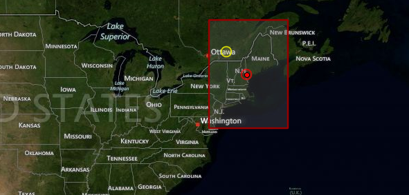
Image credit: TW
The USGS reported that 4.0 magnitude earthquake hit Maine, USA around 23:12 UTC (7:12 p.m. local time) on Tuesday, October 16, 2012. The epicenter was located 5 km (3 miles) W of Hollis Center, Maine at coordinates 43.592°N, 70.676°W. The depth was recorded at 6.6 km (4.1 miles). The epicenter location is about 32 km (20 miles) west of Portland. The quake was first estimated to be 4.6 magnitude but was later downgraded.
EMSC reported magnitude 4.0 also but depth they recorded was 2km.
The Seabrook Station nuclear plant, about 101 km (63 miles) away in New Hampshire, declared an unusual event — the lowest of four emergency classifications — but said it was not affected. The plant has been offline for refueling.
“There has been no impact at all to the plant from the earthquake and our refueling maintenance activities have not been affected,” said Alan Griffith, spokesman for Next EnergyEra Seabrook Station.
| Magnitude | 4.0 |
|---|---|
| Date-Time |
|
| Location | 43.592°N, 70.676°W |
| Depth | (4.1 miles) 6.6 km |
| Region | MAINE |
| Distances | 5 km (3 miles) W of Hollis Center, Maine 21 km (13 miles) NW of Biddeford, Maine 21 km (13 miles) NW of Saco, Maine 22 km (13 miles) WNW of West Scarborough, Maine |
| Location Uncertainty | horizontal +/- 7.6 km (4.7 miles); depth +/- 2.9 km (1.8 miles) |
| Parameters | NST=195, Nph=234, Dmin=80.2 km, Rmss=1.13 sec, Gp= 79°, M-type=centroid moment magnitude (Mw), Version=7 |
| Source |
|
| Event ID | usb000d75b |
USGS intensity and location map

Earthquakes are rare in New England but they’re not unheard of.
In 2006 there was a series of earthquakes around Maine’s Acadia National Park. The strongest earthquake recorded in Maine occurred in 1904 in the Eastport area, near the state’s eastern border with Canada according to the Weston Observatory at Boston College. It had an estimated magnitude of 5.7 to 5.9.
East Coast quakes are rarely strong enough to be felt over a wide area. A quake of magnitude 5.8 on August 23, 2011, was centered in Virginia and felt all along the coast, including in New York City and Boston. Experts say the region’s geology can make the effects felt in an area up to 10 times larger than quakes of similar size on the West Coast.
The Watchers team and our contributors bring the latest on extreme weather, earthquakes, volcanic eruptions, space weather, and all things science. We're all about making sense of the natural world and keeping you informed on what’s happening. Got a tip or a question? Hit us up using the form at newstips!
Commenting rules and guidelines
We value the thoughts and opinions of our readers and welcome healthy discussions on our website. In order to maintain a respectful and positive community, we ask that all commenters follow these rules.