
M 6.0 sea quake 256 km off the coast of Oregon
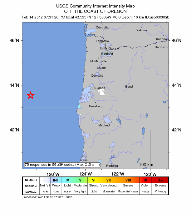
Image credit: USGS
USGS reported magnitude 6.0 quake at 3:31 UTC (Feb. 15, 2012) 256 km (159 miles) west of the coast of Oregon. Recorded depth by both USGS and EMSC was 10 km. No tsunami warning was issued, and no damage reported. This earthquake is not unusual as it occurred in a seismically active area. Earthquake-report.com characterized it as very strong harmless Sea quake.
| Magnitude | 6.0 |
|---|---|
| Date-Time |
|
| Location | 43.536°N, 127.381°W |
| Depth | 10 km (6.2 miles) |
| Region | OFF THE COAST OF OREGON |
| Distances | 256 km (159 miles) W of Coos Bay, Oregon 293 km (182 miles) WSW of Newport, Oregon 302 km (187 miles) NW of Brookings, Oregon 380 km (236 miles) WSW of SALEM, Oregon |
| Location Uncertainty | horizontal +/- 19.7 km (12.2 miles); depth +/- 6.2 km (3.9 miles) |
| Parameters | NST=205, Nph=211, Dmin=282.8 km, Rmss=1.15 sec, Gp=180°, M-type=regional moment magnitude (Mw), Version=6 |
| Source |
|
| Event ID | usb00080ib |
Seismicity map since 1900

I'm a dedicated researcher, journalist, and editor at The Watchers. With over 20 years of experience in the media industry, I specialize in hard science news, focusing on extreme weather, seismic and volcanic activity, space weather, and astronomy, including near-Earth objects and planetary defense strategies. You can reach me at teo /at/ watchers.news.
Attempting to get a handle on this seemingly increase in volcanic activities is an interesting past time!
First lets approach this by drawing a big circle. At OOOO top center of the circle Label Japan. Label each each earthquake/ volcanic event starting left, 350 degress west. Lets start putting each activity with a date, intensity, location. Earthquake With an E and volcano V. A list of each, location, intensity, and date.
One thing I have picked up on is the progressive movement around the Pacific South and back to the East and now Northward.
Secondly: The intensity has increased from reported 3.4…3.5….and we are now getting reports of 5.6….and some 6.+ February 15, 2012
Interestingly we might start with January 1, 2011, I didn’t, just January 1, 2012
Some one with good record keeping skills might start this off. The rest of us can add notes on our watch sheets hence forth.
Can we draw conclusions based on earthquake sites and progression site to site
and to the activities of volcanos? Is there a direct relationship between earthquake and the increase of volcano activities. Are the volcano causing the increase in earthquakes.
Is there some sort of relations between solar flares and Vulcanism activities?
What else?
Increase in earthquakes seldom felt before. Super Volcano quakes….Things like this put together by observation around the world would be an interesting observation for all of us.