
Atmospheric gravity waves over the Arabian Sea
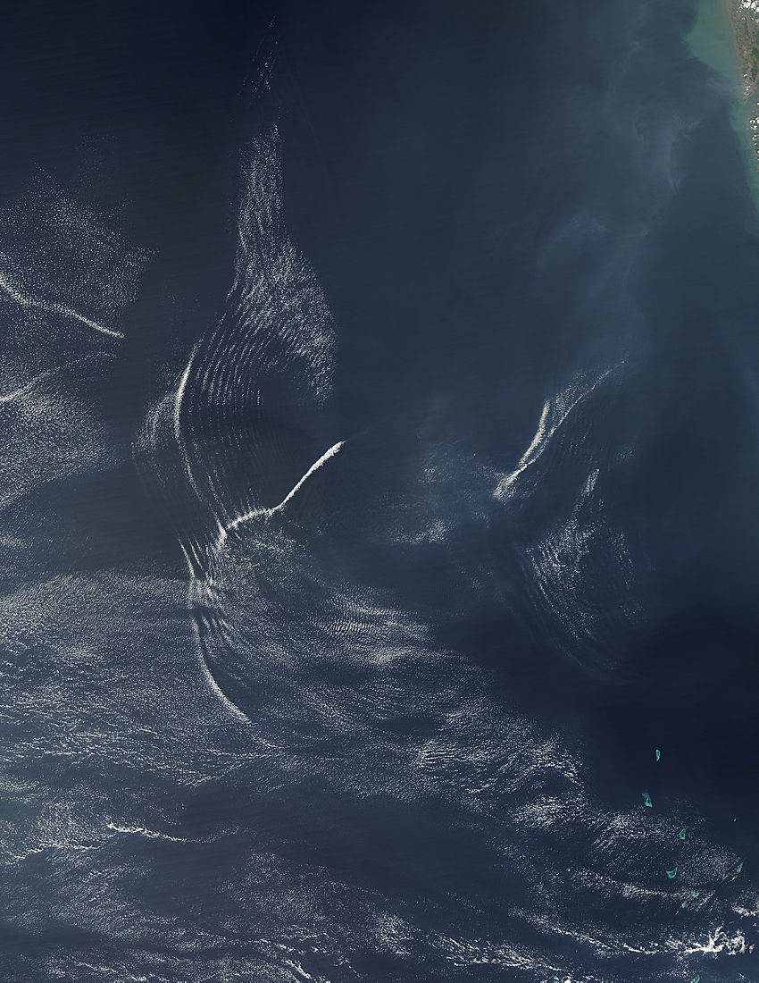
Image credit: TW
On November 15, 2011, the Moderate Resolution Imaging Spectroradiometer (MODIS) aboard the Aqua satellite passed over the Arabian Sea and captured this true-color image of a large-scale, overlapping wave pattern. The wave pattern is not caused by ocean waves, however. The pattern is the “impression” of atmospheric gravity waves on the surface of the ocean.
Gravity waves form in the atmosphere when there is a disturbance in the air layer, such as when lighter, warmer air moves upward and then gravity pulls it back down. This creates an oscillation, or wave pattern, that ripples outwards. In the trough of the wave (the low point), the air touches the surface of the ocean, causing the water to be roughened. The area between these troughs remains smooth.
This wave pattern on the water can be difficult to see, except in areas of sunglint, the area where the Sun’s rays reflect off the surface of the ocean at the same angle that a satellite sensor is viewing the surface. In this area, smooth ocean water becomes a silvery mirror, while rougher water reflects light more poorly, and appears dark. Gravity waves, therefore, can clearly be seen as bands of light and dark in the sunglint area.
The rising and falling air over the ocean doesn’t just affect the water below. When conditions are right, clouds will form on the crests of the rising waves of air, while the troughs remain cloud-free. In this image, the light-dark wave pattern in the clouds can be seen lying over a similar wave pattern on the ocean water, especially when viewed at higher resolution. (MODIS)

Earlier reporting
Nothing on Watchers was published in the last 24 hours. These are older articles.
- On October 22, 2017, a single flash of lightning stretched 515 miles from eastern Texas to near Kansas City, a distance that takes eight hours to drive, and nobody realized how far it had gone until scientists went back through the satellite data years later Epicenter
- CPC posts a slight risk of heavy rain from the Gulf Coast to the Northeast urban corridor November 25-29, and a moderate risk of West Coast wind and Sierra snow on November 25
- Florida's east coast faces a moderate flash flood risk Wednesday through Friday, with 4 to 8 inches of rain forecast and the St. Johns River near Cocoa already in major flood at 17.13 feet
- Cyclone Akvan to make landfall between Nellore and Visakhapatnam around noon on November 20, IMD forecasts 120-130 km/h winds gusting to 145

Thank you… your reports are very informative … Question.. is there a place on earth that can be observed the entire earth in real time .. like a google earth globe that can be used to inform everyone what is happening with the earth right now… like a glass globe with projection from the inside out… just asking…
well, not like a globe with a projection like you explained. However, there are apps and maps that can show you such info.
Stokes (I think) said that the gravity over the sea is greater than the gravity over the land. Of course, I had thought that the mass density was greater over the land, because most of earth sinks in water. So what’s the reason?