
Category 5 Severe Tropical Cyclone “Yasa” to strike Fiji with destructive winds, storm surge and very heavy rain
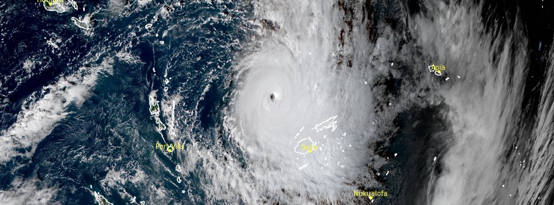
Featured image: Severe Tropical Cyclone "Yasa" at 05:20 UTC on December 16, 2020. Credit: JMA/Himawari-8, RAMMB/CIRA, TW
Yasa has rapidly intensified into a Category 5 cyclone on the Australian tropical cyclone intensity scale by 15:00 UTC on December 15, 2020, and is expected to move over Fiji on December 17, bringing destructive winds, storm surge with waves as high as 16 m (52 feet) and widespread heavy rain. Yasa is the first Category 5 cyclone in the South Pacific (east of 135 °E) since Zoe in 2002.
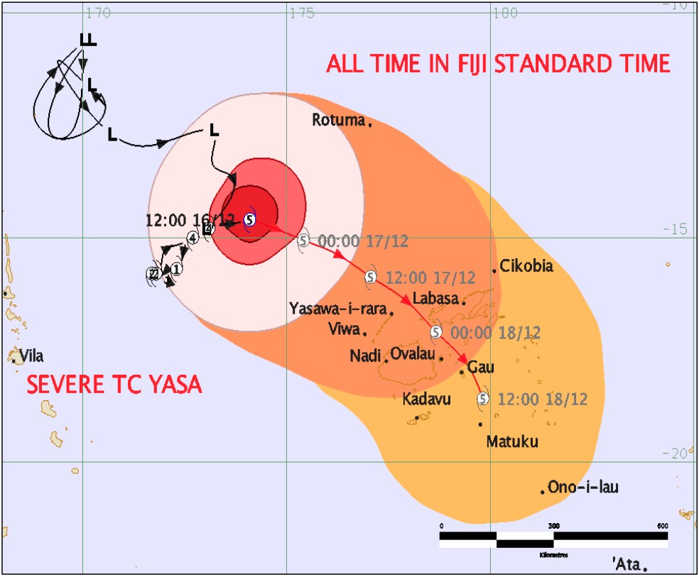
- A Tropical Cyclone Warning is now in force for Yasawa and Mamanuca Group, Viti Levu, Vanua Levu, and nearby smaller islands and expected to be in force for the rest of the group later today, December 16.
- A Tropical Cyclone Alert remains in force for the rest of Fiji.
- A Strong Wind Warning remains in force for the rest of Fiji.
- A Storm Surge and Damaging Heavy Swell Warning is now in force for coastal waters of Rotuma, Yasawa and Mamanuca Group, Viti Levu, Vanua Levu and nearby smaller islands.
- A Heavy Rain Warning remains in force for the whole of Fiji.
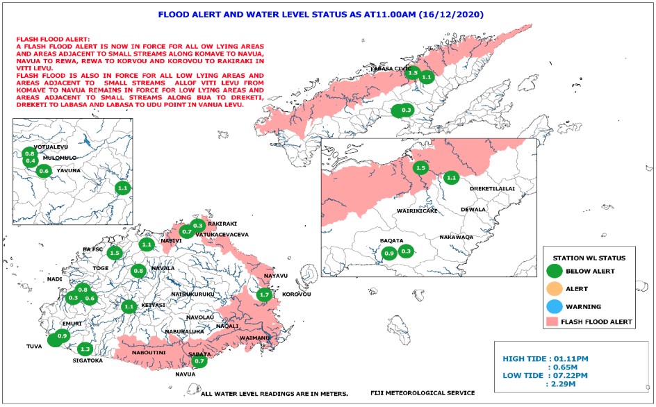
- A Flash Flood Alert is now in force for all low lying areas and areas adjacent to small streams along Komave to Navua Town, Navua Town to Rewa, Rewa to Korovou and Korovou to Rakiraki in Vanua Levu and is also in force for all low lying areas and areas adjacent to small streams of Vanua Levu along Bua to Dreketi, Dreketi to Labasa and along Labasa to Udu Point.
All non-essential civil servants are required to stay home during the height of the storm, Fiji's Disaster Management Office (NDMO) said at 22:00 LT on December 16 (10:00 UTC; Fiji's timezone is UTC+12).
The Maritime Safety Authority of Fiji issued a NO SAIL for all vessels in Fiji waters effective from 23:59 LT tonight, December 16.
All public transportation services were ordered to cease operations from 23:00 LT tonight until further notice.
The office urged people living in coastal areas to evacuate to the nearest evacuation center while they can. The Fiji Meteorological Service advised coastal dwellers to expect storm surge with waves as high as 16 m (52 feet).
Families and communities are urged to prepare emergency kits and implement family/community disaster preparedness plans.
Fijians living along coastal waters where a Storm Surge and Damaging Heavy Swell is in effect were urged to clear all loose items along the shore and within compounds to avoid further damage by storm surges.
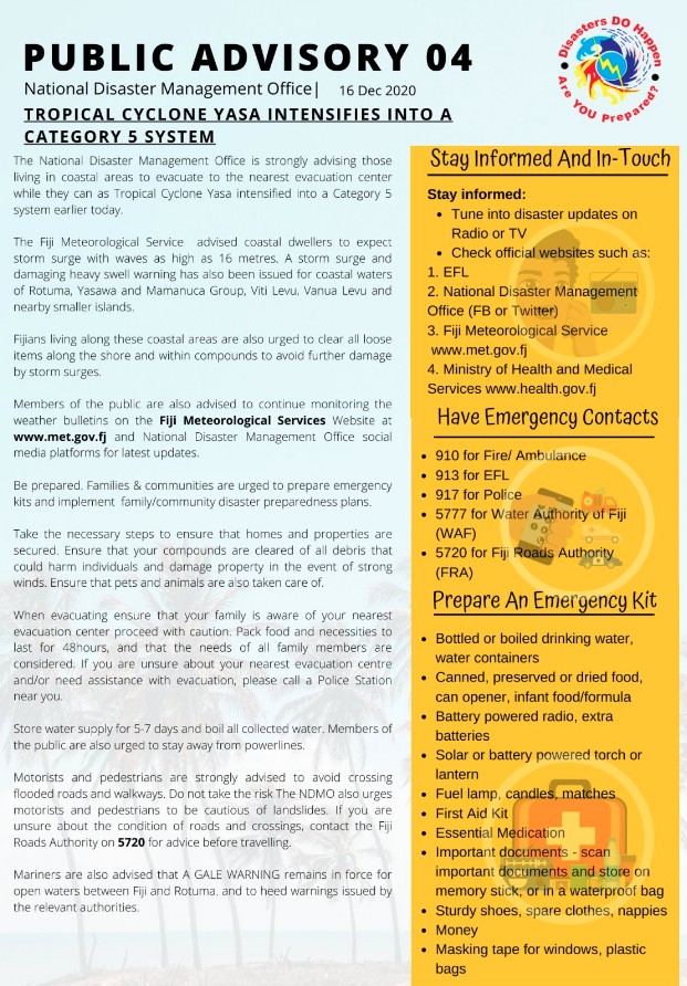
Fiji NDMO Public Advisory 04
At 15:00 UTC on December 16, Yasa had maximum sustained winds of 260 km/h (160 mph) and gusts to 315 km/h (195 mph), according to the JTWC. The system is moving over a favorable environment with warm sea surface temperatures, low vertical wind shear, and robust poleward and equatorial outflow aloft.
A continued favorable environment will allow Yasa to maintain this intensity over the next 12 hours, followed by a gradual weakening thereafter.
By 12:00 UTC on December 17, Yasa's maximum sustained winds are expected to drop to 230 km/h (145 mph).
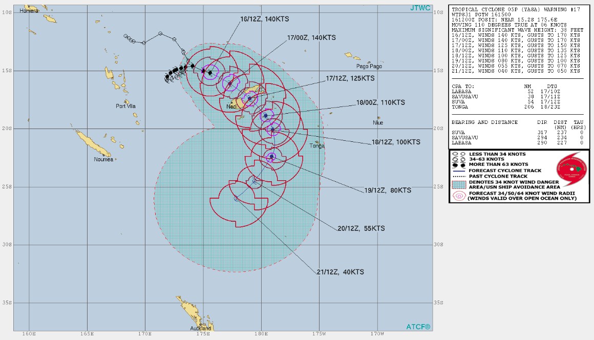
Image credit: JTWC
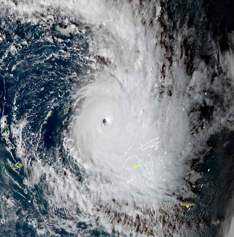
Severe Tropical Cyclone "Yasa" at 05:20 UTC on December 16, 2020. Credit: JMA/Himawari-8, RAMMB/CIRA
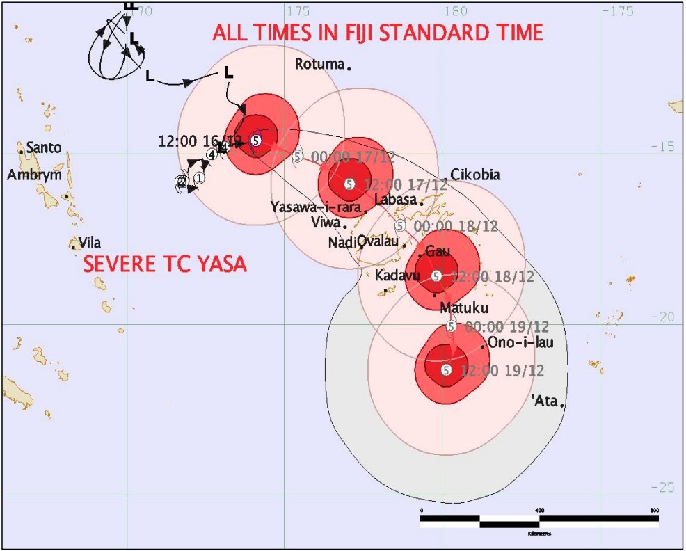
At 15:00 UTC today, Yasa's center was about 280 km (173 miles) northwest of Yasawa-i-Rara, about 360 km (223 miles) north-northwest of Nadi, and about 320 km (198 miles) south-southwest of Rotuma.
By 21:00 UTC today, the cyclone is expected to be about 65 km (40 miles) ENE of Yasawa-iRara, about 160 km (99 miles) NNE of Nadi, and about 460 km (285 miles) SSE of Rotuma.
Destructive winds are likely to begin several hours before the cyclone center passes overhead or nearby.
As Yasa tracks closer to Fiji, winds are expected to increase to damaging gale force winds with average speeds of 75 km/h (45 mph) from 03:00 LT, December 17 in Yasawa and Mamanuca Group, Viti Levu, Vanua Levu and nearby smaller islands, according to the Fiji Meteorological Department.
This is expected to further increase to destructive storm force and very destructive hurricane-force winds up to 185 km/h (115 mph) with momentary gusts up to 260 km/h (160 mph) at 15:00 LT, December 17 (03:00 UTC).
High waves of more than 5 to 7 m (16 – 23 feet) can be expected over these areas from early tomorrow. Significant wave height of 14 m (46 feet) or more and damaging heavy swells is expected when the eye of the cyclone moves closer. There is a risk of sea flooding of low-lying coastal areas especially during high tide from storm surges and damaging heavy swells on Thursday and Friday.
By Friday (LT), the whole of Fiji is expected to experience damaging winds or stronger, widespread heavy rain that can cause landslides, severe flooding and bursting of river banks, storm surge, damaging heavy swells, and high waves that can cause sea flooding in coastal areas.
Destructive storm force and very destructive hurricane-force winds can be extremely dangerous with widespread destruction.
It can cause widespread damage to properties and infrastructures, severe disruption to electrical power distribution and communication services. It can uproot big trees and cause total damage to crops and vegetation.
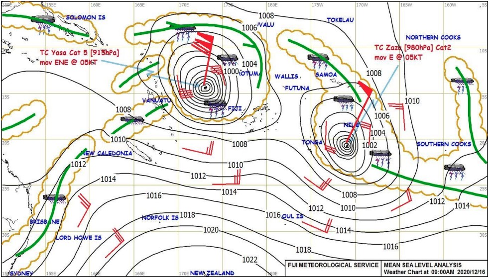
Meanwhile, Category 2 Tropical Cyclone "Zazu" has moved away from Tonga towards the ocean between Tonga and Niue.
I'm a dedicated researcher, journalist, and editor at The Watchers. With over 20 years of experience in the media industry, I specialize in hard science news, focusing on extreme weather, seismic and volcanic activity, space weather, and astronomy, including near-Earth objects and planetary defense strategies. You can reach me at teo /at/ watchers.news.
Commenting rules and guidelines
We value the thoughts and opinions of our readers and welcome healthy discussions on our website. In order to maintain a respectful and positive community, we ask that all commenters follow these rules.