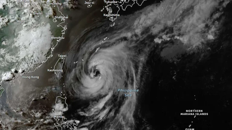
• Heavy snowfall across northern China triggers emergency responses

    Northern China experienced widespread snowfall on March 1, 2026, with snow cover exceeding 250 000 km² (96 525 mi²) and a maximum snow depth of 23 cm (9 inches). The event prompted emergency responses across several provinces, including Hebei, Shanxi, and Gansu, according to official reports.

  • Rapid ice breakup causes flood in Kanas Scenic Area, northwest China

    A sudden ice flood occurred on January 5, 2026, in the Kanas Scenic Area of Xinjiang, China, sending large ice blocks rushing downstream in the Kanas River. The short-lived event was captured on video and later described by local authorities as a localized “ice flood” caused by ice breakup due to warmer temperatures.

  • Debris strike on Shenzhou-20 leads to rare evacuation-capability gap on Tiangong station

    China launched the uncrewed Shenzhou-22 spacecraft at 04:11 UTC on November 25, 2025, to restore a safe return option for the three-member Tiangong space station crew, after debris damage earlier in the month rendered their original Shenzhou-20 return module unusable. The previous crew returned using the Shenzhou-21 arrival vehicle, leaving the current crew without an evacuation craft until Shenzhou-22’s launch. The astronauts remain in stable condition as docking procedures proceed.

  • Typhoon Ragasa to make landfall in China’s Guangdong on September 24

    Hong Kong has shut down, and Shenzhen is evacuating of 400 000 people as Typhoon Ragasa (known in the Phillippines as Nando) moves towards China. Its earlier landfall in northern Philippines on September 22, has already claimed at least 3 lives and displaced thousands, and now it threatens to wreak havoc in southern China. Ragasa is expected to make landfall in the coastal area between Shenzhen City and Xuwen County in Guangdong Province on September 24.

  • Super Typhoon Ragasa moving toward Philippines, China and Vietnam

    Typhoon Ragasa, known locally as Nando, intensified into a super typhoon 00:00 UTC (08:00 LT) on September 21, 2025, east of Cagayan, Philippines. By 09:00 UTC, its center was located 450 km (280 miles) east of Aparri with sustained winds of 185 km/h (115 mph) and gusts up to 230 km/h (145 mph). The system is moving west-northwest toward Batanes and the Babuyan Islands, bringing life-threatening storm surges exceeding 3 m (10 feet), destructive winds, and very rough seas.