
Earth’s magnetic power is shifting from Canada to Siberia
Satellite measurements from 2014 to 2025 show that the northern hemisphere’s strongest magnetic field region is shifting from Canada toward Siberia as the Canadian lobe weakens and the Siberian lobe intensifies. The redistribution is directly linked to continued eastward drift of the north magnetic pole, which is moving at about 36 km/h (22 mph). The shift is altering magnetic declination patterns and measurably affecting navigation systems, requiring frequent updates to the World Magnetic Model used by aircraft, ships, submarines, and consumer GPS devices. Over the same 11-year interval, the southern hemisphere’s strong-field region between Australia and Antarctica remained largely stable.
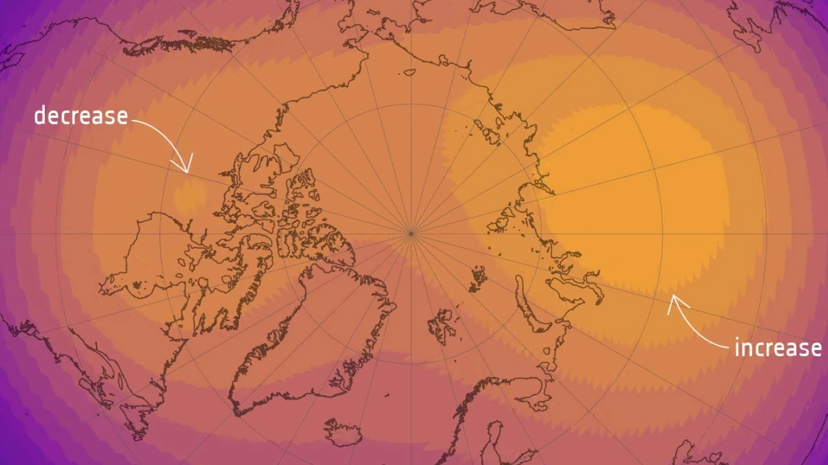
Magnetic Field Intensity - 2025. Credit: ESA (Data source: Finlay, C.C. et al., 2025)
For four centuries, the northern hemisphere’s most powerful concentration of Earth’s magnetic field sat beneath Canada, anchored in the deep currents of its outer core. Now, high-precision satellite data show that dominance is shifting eastward toward Siberia.
Data from the European Space Agency’s Swarm satellite constellation, compiled over 11 years of continuous observation, show that the strong-field region under Canada is steadily shrinking and weakening, while the equivalent region under Siberia is expanding and intensifying — a geophysical power transfer with real-world consequences for navigation systems worldwide.
The findings appear in a study published in Physics of the Earth and Planetary Interiors by researchers at the Technical University of Denmark.
The study maps magnetic field intensity at Earth’s surface between 2014 and 2025, measuring how much area is enclosed within specific field-strength thresholds. The picture in the northern hemisphere is unambiguous.
In Canada, the area enclosed within the 57 000 nanoTesla (nT) field-strength contour shrank by 0.65% of Earth’s total surface area over the 11-year period. The peak field strength in the Canadian sector fell from 58 832 nT to 58 031 nT — a drop of 801 nT, or 1.4%. The area within the 55 000 nT contour decreased by 0.41% of Earth’s surface area over the same period.
Opposite changes have unfolded across Siberia, where the strong-field region has steadily widened and intensified. Between 2014 and 2025 its area grew by 0.42 % of Earth’s surface and its maximum field strength rose by 260 nT — from 61 359 nT to 61 619 nT. Already dominant a decade ago, the Siberian lobe now leads by a wider margin.
Across the southern hemisphere, the strong-field region situated between Australia and Antarctica has remained almost unchanged throughout the same period. Its maximum field intensity fell by just 37 nT over the same 11 years, less than one-twentieth of the Canadian decline, confirming that the dramatic reorganisation is a northern hemisphere phenomenon.
The surface changes are driven by what is happening roughly 3 000 km (1 800 miles) below ground, at the boundary between Earth’s liquid outer core and the surrounding rocky mantle. Two large concentrations of strong magnetic flux sit beneath Canada and Siberia, respectively, and changes in how molten iron flows between them determine which one exerts greater pull.
Research published alongside and prior to the Swarm study points to a process that began intensifying between 1970 and 1999: changes in core flow elongated and then weakened the Canadian flux lobe, while the Siberian lobe grew relatively stronger.
The Swarm data now quantify the consequences of that process playing out over the following decade and a half: the Canadian lobe at the core-mantle boundary has decreased in size and strength, while the Siberian concentration has expanded.
“The field is getting weaker in Canada but stronger around Siberia, and that pulls the magnetic pole towards Siberia,” Ciarán Beggan, a geophysicist at the British Geological Survey, said.
The migration of magnetic power in the subsurface is directly tracking the movement of the north magnetic pole itself — the point on Earth’s surface where a compass needle points straight down.
The pole sat within the Canadian Arctic for at least 400 years before beginning to accelerate toward Russia in the 1990s. By the early 2000s, it was moving at a record speed of around 55 km/h (34 mph). More recently, that pace has slowed significantly, to approximately 36 km/h (22 mph) per year, according to the most recent NOAA report.
The British Geological Survey has described it as the largest deceleration in recorded history. Scientists at the BGS predict the pole will continue drifting toward Siberia over the next five years, albeit more slowly.
The 11-year Swarm record captures this slowdown in the magnetic field data itself: the rate of change in Canada and Siberia has been steady but not accelerating since 2014, consistent with the pole’s deceleration observed at the surface.
The World Magnetic Model (WMM), the global standard used by military and civilian aircraft, ships, submarines, and consumer GPS devices, must be updated to track the field’s movement. NOAA and the British Geological Survey released a new version of the WMM in 2025, the most detailed ever produced, with spatial resolution ten times greater than its predecessors.
The urgency of the update is illustrated by the navigation error it corrects: a traveller relying on the previous model for a 8 500 km (5 280 miles) journey from South Africa to the United Kingdom could have ended up as much as 150 km (93 miles) off course.
The new WMM incorporates the ongoing Canada-to-Siberia shift. NOAA’s most recent annual report, released in January 2026, confirmed that the north magnetic pole’s position remained close to model predictions over the past year, moving at roughly 36 km/h (22 mph) — still fast enough that any five-year-old navigation chart is measurably out of date.

The Canada-to-Siberia transition is not without precedent on geologic timescales. Analysis of Arctic sediment cores from Svalbard, published in 2022, showed that the magnetic north pole has oscillated between the two regions multiple times over the past 22 000 years, with periods of rapid drift punctuating long stretches of relative stability.
What is new is the ability to watch it happen in near-real time. The Swarm constellation orbits Earth 15 to 16 times daily, producing a continuous record that, for the first time, allows researchers to separate the slow drift of the core field from shorter-period fluctuations caused by ocean currents, ionospheric currents, and space weather.
ESA has stated its intent to keep Swarm operating beyond 2030, when a period of reduced solar activity will provide even cleaner access to the core signal.
By then, the tug-of-war between Canada and Siberia will have been running for half a century, and the Swarm record will be able to provide even more insights.
References:
1 Finlay, C. C., Olsen, N., & the Swarm Science Team (2025). Core field changes from eleven years of Swarm satellite observations. Physics of the Earth and Planetary Interiors, 368, 107447. https://doi.org/10.1016/j.pepi.2025.107447
2 State of the Geomagnetic Field – NOAA/NCEI – December 2025
I'm a dedicated researcher, journalist, and editor at The Watchers. With over 20 years of experience in the media industry, I specialize in hard science news, focusing on extreme weather, seismic and volcanic activity, space weather, and astronomy, including near-Earth objects and planetary defense strategies. You can reach me at teo /at/ watchers.news.
Merlin, thank you for sharing, I appreciate your thoughts.
Competing geodetic instability forces?
Speaking to this article, how may one lobe ‘grab’ a stable orbit? If anything it’s more instability?
Yes, these energies involving fourth-power law at minimum because magnetic possibly folded, so ‘rapid’ in time and strength.
Why not your suggested rotation within perhaps 12 hours? Certainly more than – similar but foggy upside down, thinking seismic stress alone progenitor M12s potential in your scenario?
Tilt, new pole geoid-dominant, tilt again on return to gravito-magnetic-pinning where we are currently?
It’s more than a ‘magnet’ and certainly not a ball of iron ‘down there’, this is dense plasma physics and as such speaks to more forces and energy than modelled in the unclassified world. The ‘ball of iron’ likely mis-direction, as ‘bar-magnet’.
What critical thinking lead to your comment? Your strongest evidence? Your weakest evidence guiding more of your original research?
It certainly demands a very ‘grown-up’ head to balance such thoughts with everyday life. The stuff of ontological-shock, not many it is appropriate to share this with, sharing does help us process and check our thinking. Thank you again Merlin.
I am very grateful to The Watchers for hosting this opportunity.
Mensonge.
Ce que l’on ne vous dis pas. les vérités cachées du pouvoir politique, soulignant l’importance de remettre les choses à l’endroit et de rompre avec le cynisme, le mensonge pour affronter la réalité de ce qui va arriver à notre planète.
Le monde tel que nous le connaissons disparaîtra dans moins de 20ans.
Suite à un déplacement des pôles magnétiques et un basculement de 90 degrés de la croûte terrestre vers les années 2035/2040.
Description détaillée d’un globe où l’Inde occupe désormais le pôle Nord et l’Amérique du Sud le pôle Sud
Aspect: Conséquence principale extinction massive. Détails
Orientation des continents. L’Inde devient le point central du pôle Nord, l’Amérique du Sud du pôle Sud. Tous les autres continents sont « déroulés » autour de ces deux points. L’Europe, l’Afrique et l’Asie du Sud‑Est s’étendent vers l’est et l’ouest du pôle Nord, tandis que l’Australie, l’Antarctique (ou son équivalent) et les îles du Pacifique se trouvent autour du pôle Sud.
Distribution des océans Les océans restent les mêmes mais leurs formes sont fortement déformées. L’océan Indien entoure désormais le pôle Nord, tandis que l’océan Pacifique et l’océan Atlantique forment des bandes qui relient les deux pôles en spirale. L’océan Atlantique traverse la zone entre l’Europe et l’Amérique du Sud, créant une « ceinture » maritime autour du pôle Sud.
Climat. Les zones climatiques se déplacent avec les latitudes, mais la position des continents modifie les courants atmosphériques. Pôle Nord (Inde) climat polaire, mais la présence d’une masse continentale importante (Inde) pourrait créer un continent glaciaire plus épais que dans la réalité.
Pôle Sud (Amérique du Sud) climat polaire similaire, mais la topographie montagneuse des Andes pourrait influencer la formation de glaciers.
Zones tempérées: se situent autour des latitudes intermédiaires, où l’Europe, l’Afrique du Nord, le Brésil et le Chili se trouvent.
Zones tropicales: se retrouvent près de l’équateur, qui serait désormais une bande traversant l’océan Pacifique et l’océan Atlantique.
Circulation des courants marins Les courants sont réorientés par la nouvelle disposition des continents- Le courant équatorial du Pacifique serait interrompu par la présence de l’Amérique du Sud au pôle Sud, créant un nouveau système de circulation vers le pôle Nord. Le Gulf Stream (courant chaud de l’Atlantique) serait dévié vers le sud‑est, affectant les climats de l’Europe et de l’Afrique de l’Ouest. Vue du pôle Nord (Inde)
Imaginez un disque où le centre est occupé par le sous‑continent indien, recouvert de glace. Autour, les chaînes de l’Himalaya s’étendent vers le sud‑est, tandis que le plateau tibétain forme une zone élevée.
L’Europe et l’Afrique du Nord apparaissent comme des arcs à la périphérie du disque, séparés par l’océan Indien gelé.
Vue du pôle Sud (Amérique du Sud)
Le centre du disque est la Patagonie et le Chili, recouverts de glaciers.
Les Andes forment une barrière verticale qui sépare l’océan Pacifique (à l’ouest) de l’océan Atlantique (à l’est).
L’Australie et les îles du Pacifique se trouvent sur le bord du disque, entourées d’eaux froides.
Vue équatoriale
Une bande horizontale traverse le centre du globe, constituée principalement d’océans (Pacifique et Atlantique).
Les zones tropicales (Amazonie, Congo, Indonésie) sont dispersées le long de cette bande, mais leurs climats sont influencés par la proximité des pôles glacés.
Les cartes exactes nécessiteraient un logiciel de projection géographique capable de repositionner les continents selon les nouvelles coordonnées.
En résumé, placer le Bengale (l’inde) au pôle Nord et l’Amérique du Sud au pôle Sud inverserait les zones climatiques et bouleverserait les systèmes océaniques, la biodiversité et les modes de vie humains (si rescapés). Aucun modèle cartographique exact n’est disponible pour illustrer ce scénario catastrophique mais bien réel d’une extinction massive pour l’humanité existante.
Quick thought, potentially linking to the recently-featured paper by Biggin et al.
( https://watchers.news/epicenter/scientists-discover-deep-earth-structures-influencing-the-planets-magnetic-field/ )
Might we then posit a resulting heat-flux increase on the Siberian side? We know when the trend began, and the rate of travel estimated(?).
While a heat-flux reduction on the Canadian side may occur, we have amount, entropy and flow-mixing to consider, so our results may be correspondingly mixed?
(Also, El-Nino-La-Nina; could it be??!)
What if… down in the core driving-seat, on the Siberian lobe entropy increases, while on the Canadian lobe our entropy decreases, perhaps part of a recharge cycle?
A real (REAL!) super-capacitor, that self-charges once healed from re-forming??