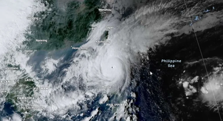
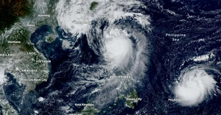
• Ex-Hurricane “Kirk” brings record breaking floods in Seine-et-Marne, France

    Torrential rains from Ex-Hurricane “Kirk” caused widespread flooding across Seine-et-Marne, France, on Thursday, October 10, 2024, with several rivers surpassing water levels recorded during the 2016 floods. The Grand Morin River rose to 3.66 m (12 feet), prompting evacuations and power outages in affected areas. Other regions were also severely impacted, including Paris, where the National Assembly was inundated.

  • 7th confirmed tornado of the day hits Florida as Milton’s storm surge begins

    Meteorologists at the National Weather Service in Miami have confirmed the 7th tornado linked to Hurricane “Milton” just hours before its expected landfall in Florida. As of 14:40 LT, 39 Tornado Warnings have been issued, with more tornadoes possible through the night. Tropical-storm-force winds have begun impacting Florida’s west coast, while rising water levels at the Naples Pier indicate the start of Milton’s storm surge across southwestern coastal areas. Multiple warnings remain in effect across the Florida peninsula.

  • Large area of destructive storm surge forecast as extremely dangerous Hurricane “Milton” hits Florida

    Category 5 Hurricane “Milton” is moving NE toward Florida, U.S. at 22 km/h (14 mph) with maximum sustained winds of 260 km/h (160 mph). Milton is forecast to make landfall late tonight or early Thursday along the Florida Gulf Coast, threatening large area with severe storm surges, destructive winds, and heavy rainfall.

  • Yucatán Peninsula in path of extremely dangerous Category 5 Hurricane “Milton” — Florida braces for major impact on Wednesday

    Hurricane “Milton” rapidly intensified on Monday, October 7, 2024, and is now a major category 4 hurricane on the Saffir-Simpson Hurricane Wind Scale. The National Hurricane Center (NHC) expects Milton to become a Category 5 hurricane today, making it the strongest Gulf of Mexico hurricane this late in the calendar year in the satellite era (since 1966). Milton is forecast to move near or just north of the Yucatán Peninsula today and Tuesday, then cross the eastern Gulf of Mexico and approach the west coast of the Florida Peninsula by Wednesday.

  • Tropical Storm “Leslie” forecast to become a hurricane in a day

    Tropical Storm “Leslie” — the 12th named storm of the 2024 Atlantic hurricane season — is forecast to become a hurricane in a day or so. As of 15:00 UTC on Thursday, October 3, 2024, the storm was getting stronger and was located about 870 km (540 miles) southwest of the southernmost part of Cabo Verde Islands.