
Record rainfall floods roads and disrupts rail services in Nagoya, Japan
Nagoya recorded 104.5 mm (4.1 inches) of rain in one hour on September 8, 2026, setting an all-time station record as flooding disrupted roads and rail services. Nagoya City issued Level 5 Emergency Safety Measures for communities along the Kanare, Yada and Ueda rivers, while the Japan Meteorological Agency and the Ministry of Land, Infrastructure, Transport and Tourism issued a Level 5 flood special warning for the Shonai River system at 18:20 LT (09:20 UTC). The municipal Level 5 measures were downgraded at 22:25 LT (13:25 UTC), while local media reported four injuries across Aichi Prefecture.

The Nagoya observation station recorded a maximum one-hour rainfall total of 104.5 mm (4.1 inches) and a 12-hour total of 213 mm (8.4 inches) by 18:00 LT (09:00 UTC) on September 8. This was the highest hourly rainfall on record, with records at Nagoya going back to 1890.
JMA identified a linear precipitation band over western Aichi Prefecture and the Mino region of Gifu Prefecture during the event.
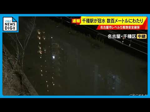
Nagoya City issued Level 5 Emergency Safety Measures for communities along the Kanare River at 17:15 LT (08:15 UTC), citing rising water levels and the possibility that inundation was already occurring.
The emergency covered Fujimidai, Miyane and Chiyodabashi in Chikusa Ward; Moritaka-nishi and Moritaka-higashi in Moriyama Ward; and Kanare, Yutakagaoka and Hikiyama in Meito Ward.
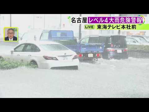
At 17:55 LT (08:55 UTC), the city expanded Level 5 Emergency Safety Measures to communities along the Yada and Ueda rivers. Local reporting said the combined measures covered 607 879 households and 1 172 102 people across 14 wards.
The city instructed people in dangerous locations to secure their safety immediately, including by moving to a higher floor or a nearby building less exposed to flooding. Level 4 evacuation orders were issued along several other waterways as water levels rose.
Nagoya City established a disaster response headquarters at 15:34 LT (06:34 UTC), after a Level 4 Urgent Warning for heavy rain was issued.
At 18:20 LT (09:20 UTC), JMA and MLIT issued a Level 5 flood special warning for the Shonai River system, stating that flooding had occurred or was extremely likely to have occurred.
The affected forecast area included Nagoya, Seto, Kasugai, Komaki, Ichinomiya, Inazawa, Kiyosu, Kitanagoya and Ama, along with Toyoyama, Ōharu and Kanie in Aichi Prefecture and Tajimi and Toki in Gifu Prefecture.

The Seko reference observation station on the Yada River reached the designated flood-occurrence level. JMA and MLIT said flooding might already have occurred and that parts of Nagoya could be inundated.
At 17:20 LT (08:20 UTC), JMA and MLIT listed the Gojo, Kanare, Jizo, Yada and Kanie rivers above their flood-danger levels. The Ogiyama River in the Tenpaku system was also above its flood-danger threshold.
The Yada River subsequently came under the Level 5 flood special warning issued at 18:20 LT.
Nagoya City downgraded the Level 5 Emergency Safety Measures for the Kanare, Yada and Ueda rivers to Level 4 evacuation orders at 22:25 LT (13:25 UTC) after water levels fell below the relevant criteria.
At 23:35 LT (14:35 UTC), the city lifted Level 4 evacuation orders for the Tenpaku, Oyama, Ogiyama, Kanie, Shinkawa, Sumiyoke, Horikawa, Shinhorikawa, Shin-Jizo, Ueda, Yamazaki, Hatta, Kanare, Tenjin and Moriyama rivers. The Level 4 evacuation order for the Yada River remained in effect at that update.
At 00:40 LT on September 9 (15:40 UTC on September 8), the Shonai River warning was reduced from Level 5 to a Level 2 flood advisory. Authorities said water levels were expected to remain above the flood-advisory threshold.
Four people had been injured across Aichi Prefecture during the event: one in Nagoya’s Nishi Ward, two in Kitanagoya and one in Kanie.

Roads and buildings were flooded across Nagoya. An approximately 305 m (1 000 feet) stretch of JR Chuo Line track was submerged between Chikusa and the area toward Ozone.
Meanwhile, multiple vehicles were abandoned in flooded underpasses in Minato Ward. All occupants of the vehicles had escaped, and no casualties associated with the incident were reported.
Tokaido Shinkansen services were suspended after rainfall gauges between Nagoya and Gifu-Hashima exceeded JR Central’s operating threshold. The disruption affected wider sections of the Tokaido and Sanyo Shinkansen networks before services began resuming at approximately 17:15 LT (08:15 UTC), although delays and cancellations continued.
JR Chuo Line service between Nagoya and Nakatsugawa remained suspended for the rest of September 8. Local reporting said the suspension would continue from the first scheduled trains on September 9.
Nagoya’s municipal subway resumed operations progressively across all lines from 22:30 LT (13:30 UTC), while city bus services remained suspended for the rest of September 8.
Nagoya City opened temporary facilities near Nagoya, Kanayama, Fushimi and Sakae stations for people unable to return home because of the transport disruption.
The city also announced that municipal elementary, junior-high and high schools, special-needs schools and kindergartens would be closed on September 9 because of the effects of the heavy rainfall.
Authorities continued advising residents to follow municipal evacuation information and stay away from rivers, low-lying ground, underground facilities, and underpasses. People were warned not to drive into areas susceptible to inundation or enter flooded roads.
References:
1 Level 5 flood special warning issued for the Shonai River – JMA – September 8, 2026
2 Emergency and evacuation information – Nagoya City – September 8, 2026
3 Shonai River warning and heavy-rain observation report – Ministry of Land, Infrastructure, Transport and Tourism – September 8, 2026
Feature image: Flooded roads in Nagoya, Japan, on September 8, 2026. Credit: 東海テレビ ニュースONE

Rishav Kothari is Editor-in-Chief of The Watchers, where he runs the newsroom and covers earthquakes, volcanoes, severe weather and space weather.
Published in the last 24 hours
- How did one flash of lightning, lasting about seven seconds, stretch 829 km across five US states, beat the previous record by 61 km, and only be recognized as the longest ever measured nearly eight years later?
- A meteorite blew a crater beside a village near Lake Titicaca in 2007, and dozens of villagers who went to see it got headaches and nausea, though tests found nothing the rock had added to the water Epicenter
- The people who pay closest attention to the weather are the ones storms have already cost the most, a study of 946 students found, with one damaging storm making little difference to how much attention a student paid, but two or more making a clear one Epicenter
- The sea is falling in Juneau, Alaska, because land freed from melted glaciers is rising about 0.6 inches a year Epicenter
