
7 tornadoes confirmed after Chicago-area storms produced destructive winds and flooding on July 27, Illinois
Seven tornadoes, destructive straight-line winds, hail up to 7.6 cm (3 inches) and flash flooding affected northeastern Illinois and northwestern Indiana on July 27, 2026. Straight-line winds caused most of the damage in and near the Chicago metropolitan area. Meanwhile, Cook County issued a disaster proclamation after severe storms caused flash flooding, structural damage, transportation disruption and widespread power outages.
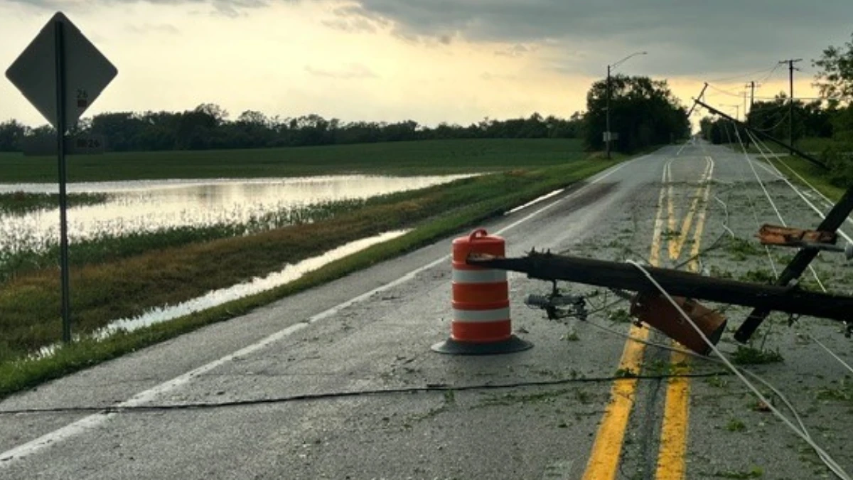
Powerline downed by severe storms in Chicago, Illinois on July 27, 2026. Credit: ComED
Heat and oppressive humidity generated extreme atmospheric instability, producing favorable conditions for severe weather.
A subtle weather disturbance interacted with the unstable air mass, producing thunderstorms from eastern Wisconsin into northeastern Illinois during the morning of July 27.
An unseasonably high degree of wind shear allowed some storms to become severe quickly, according to National Weather Service Chicago (NWS Chicago).
Powerful supercells moved southeast during the early and middle afternoon, producing tornadoes, extensive straight-line wind damage, and hail up to 7.6 cm (3 inches).

A separate line of severe storms originating in eastern Wisconsin caused additional scattered wind damage across parts of the Chicago metropolitan area later in the afternoon. Exceptionally moist air within the storm environment supported torrential rainfall rates and flash flooding in suburbs outside Chicago.
Straight-line winds caused most of the damage in and near the Chicago metropolitan area. Southern Cook County and eastern Will County were among the hardest-hit areas, including Chicago Heights, Ford Heights, Sauk Village, Steger, Crete, Monee, University Park, Frankfort and Beecher.
Gusts of 130–145 km/h (80–90 mph) caused substantial tree damage and multiple instances of structural damage across that corridor.

Seven tornadoes occurred between 22:25 and 23:35 CDT on July 27 — 03:25–04:35 UTC on July 28. Five were rated EF0 and two were rated EF1. The two EF1 tornadoes overlapped in time as they crossed southern Cook County and the Illinois–Indiana state line.
The longer of the two EF1 tornadoes began at 23:17 CDT just east of Interstate 57 and moved eastward, crossing Interstate 80 on the northwest side of Country Club Hills. It continued east-northeast through Hazel Crest, bringing down trees and limbs and removing roofing material from several apartment buildings along 171st Street.
After crossing Interstate 80 again at its junction with Interstate 294, the tornado made an unusual counter-clockwise loop as it moved into eastern Markham and southwestern Harvey. Damage in this section consisted primarily of tree damage and cosmetic damage to structures.

The tornado reached its northernmost point between West 154th and West 155th streets before looping southward and rapidly accelerating as it re-entered Markham and Hazel Crest. It reached peak intensity in this area, removing the roof of an industrial building on West 167th Street and damaging exterior walls and roofing at an apartment complex on 171st Street.
After crossing Interstate 80 for a third time, the tornado continued southeast through the northern and eastern sides of Homewood. Four double-stacked intermodal containers weighing approximately 68 tonnes (75 US tons) each were tipped over in a rail yard, and numerous additional trees were damaged.
The tornado caused further tree damage on the northwest side of Glenwood before dissipating near Glenwood Academy at 23:33. It had estimated peak winds of 175 km/h (110 mph), a track length of 18.3 km (11.4 miles) and a maximum width of 183 m (600 feet). No injuries or deaths were reported.

The second EF1 tornado touched down at 23:28 CDT just east of State Route 394 and moved northeast into Lansing. The most severe damage occurred in a neighborhood near Heritage Middle School, where several homes sustained damage to exterior walls and roofs.
The tornado continued northeast, causing primarily tree damage and cosmetic structural damage as it crossed into Indiana. It lifted on the far western side of Munster at 23:35.
The Lynwood–Lansing–Munster tornado had estimated peak winds of 175 km/h (110 mph), a track length of 6 km (3.7 miles), and a maximum width of 206 m (675 feet). One injury and no deaths were reported.

A brief EF0 tornado developed at 22:25 CDT near Stacy Court and Railroad Street in unincorporated North Glen Ellyn. It moved south-southeast across parts of Glen Ellyn before dissipating at 22:27 northwest of Glenbard West High School, near Hawthorne Boulevard and Park Boulevard.
The Glen Ellyn tornado had estimated peak winds of 120 km/h (75 mph), a track length of 1.4 km (0.9 miles), and a maximum width of 69 m (225 feet). Large branches fell onto power lines and damaged homes and a vehicle. Additional sporadic tree damage occurred farther south. No injuries or deaths were reported.
Another EF0 tornado formed at 22:25 CDT near East Liberty Drive and South Washington Street, south of Wheaton College. It moved southward for 1.6 km (1 mile) before dissipating near Alchester Drive at 22:27.
The Wheaton tornado had estimated peak winds of 120 km/h (75 mph) and a maximum width of 91 m (300 feet). A concentrated damage corridor was identified near East Indiana Street and Campbell Avenue, where the tops of several softwood trees were snapped, and numerous limbs were brought down. Sporadic tree damage continued farther south. No injuries or deaths were reported.
Additional damage in the Wheaton area was likely associated with a swath of damaging straight-line winds that crossed the area several minutes after the tornado.
At 22:39 CDT, an EF0 tornado touched down near Maple Avenue and Brookbank Road before moving southeast through neighborhoods on the south side of Downers Grove. The tornado lifted over McCollum Park at 22:43.
The Downers Grove tornado had estimated peak winds of 135 km/h (85 mph), a track length of 3.5 km (2.2 miles), and a maximum width of 91 m (300 feet). Damage consisted of snapped and uprooted trees and downed branches. No injuries or deaths were reported.
The Downers Grove tornado occurred within a broader region of straight-line wind damage. Surveyors identified the tornado through a corridor of locally more intense wind damage, including branches torn from the tops of trees, and a subtle radar debris signature visible in KLOT radar imagery.

A brief EF0 tornado touched down at 22:58 CDT near or just northeast of the intersection of Illinois Route 53 and Material Services Road, across from Romeoville High School. Its path was determined from a storm survey and TMDW radar data.
The tornado moved southward along Route 53 and passed directly over the Lewis University campus before lifting near Renwick Road at 23:03. It had estimated peak winds of 130 km/h (80 mph), a track length of 4.2 km (2.6 miles), and a maximum width of 101 m (330 feet).
Damage at Lewis University included numerous downed and snapped tree limbs, damage to a baseball-field dugout and fencing, and damage to an HVAC system on the roof of a university building. No injuries or deaths were reported.
An EF0 tornado formed at 23:04 CDT near West 131st Street and Tampier Slough before moving southeast across western Orland Park. Numerous trees were brought down before the tornado lifted at 23:08 in a neighborhood west of Orland Square Mall.
The Orland Park tornado had estimated peak winds of 135 km/h (85 mph), a track length of 4.7 km (2.9 miles), and a maximum width of 229 m (750 feet). No injuries or deaths were reported.
The NWS reported rainfall totals of 100.3 mm (3.95 inches) near Bridgeview, Illinois, 94 mm (3.70 inches) near Highland, Indiana, and 92.7 mm (3.65 inches) southeast of Monee near Bult Field.

A disaster proclamation was issued by Cook County Board President Toni Preckwinkle on July 30.
“Earlier this week, severe storms brought significant damage and disruption to communities across Cook County,” said President Preckwinkle. “I am grateful for the collaboration of our municipal partners, the State of Illinois, first responders, utility providers and Cook County Emergency Management and Regional Security as we continue responding to the needs of impacted communities and businesses. My administration will continue standing with residents, supporting local recovery efforts and pursuing all available resources to help communities rebuild.”
The Cook County Department of Emergency Management and Regional Security worked with more than 15 municipalities, coordinating requests for generators, excavators and portable light towers.
County agencies and municipal partners conducted debris removal, road clearance and damage assessments, while coordination continued with ComEd, the American Red Cross and the Salvation Army.
References:
1 July 27, 2026: Intense Severe Storms Produce Multiple Tornadoes, Extensive Wind Damage, Damaging Hail, and Flooding – NWS – July 30, 2026
2 Cook County Issues Disaster Proclamation for July 27 Storm Event – Cook County Government – July 30, 2026

I am an Assistant Editor and Severe Weather & Science Journalist at The Watchers, specializing in real-time severe weather coverage, geophysical event reporting, and research-driven scientific analysis. You can reach me at rishav(at)watchers(.)news.

Commenting rules and guidelines
We value the thoughts and opinions of our readers and welcome healthy discussions on our website. In order to maintain a respectful and positive community, we ask that all commenters follow these rules.