
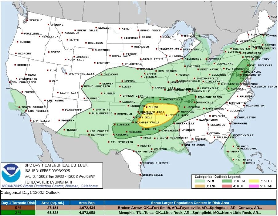
Severe thunderstorms with tornado risk forecast for eastern Oklahoma and western Arkansas
The southern Plains and Ozarks face a severe weather outbreak on September 23, 2025, with the Storm Prediction Center warning of supercells capable of producing tornadoes, very large hail, and damaging winds from eastern Oklahoma and northeast Texas into western Arkansas. Storms are expected to intensify this afternoon and evening (local time), with tornado potential maximized across northeastern Oklahoma into western Arkansas.
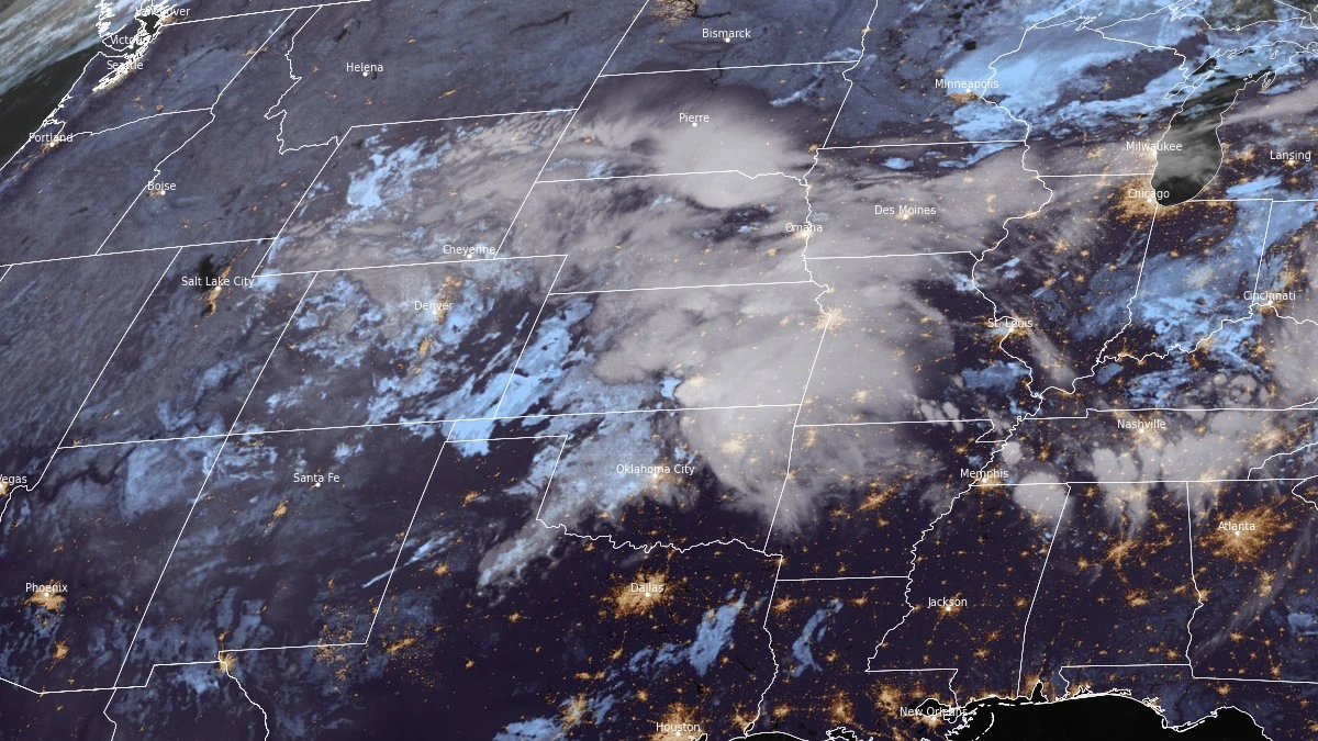
Satellite image of storms over central U.S. at 09:40 UTC on September 23, 2025. Credit: NOAA/GOES-East, RAMMB/CIRA, The Watchers
- Thunderstorms are expected on Tuesday, September 23, from the Great Lakes southwest through the Middle Mississippi Valley into the central and southern Plains.
- The greatest concentration of storms is forecast for Tuesday afternoon and evening along frontal waves from the Lower Ohio Valley through the Mid-South, Ozarks, and ArkLaTex where a Slight Risk of Excessive Rainfall level 2/4 is in effect for scattered flash flooding.
- Additional isolated flash flooding is possible across the broader region through Tuesday night.
- A similar area from the Ozarks southwest into the Red River Valley faces a severe weather threat late Tuesday into the overnight hours, with the Storm Prediction Center outlining a Slight Risk level 2/5 for very large hail, damaging winds, and a few tornadoes.
Supercells capable of producing tornadoes, very large hail, and damaging winds are expected across eastern Oklahoma, western Arkansas, northeast Texas, and the Ozarks on Tuesday, September 23, 2025.
The U.S. Storm Prediction Center (SPC) issued a Slight Risk (level 2/5) for severe thunderstorms in this corridor, warning that tornado potential remains uncertain but could become significant if conditions align.
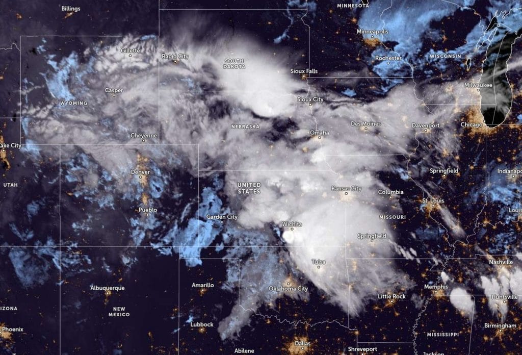
A large storm system moving across the southern Rockies and High Plains is expected to strengthen a cold front stretching into Kansas and Oklahoma. Strong winds higher in the atmosphere will interact with this front and create conditions for thunderstorms to intensify as the system pushes east into the Mississippi Valley.
Storms are forecast to move into northwest Arkansas and southwest Missouri on Tuesday morning, bringing a chance of strong winds and hail. The cooler air left behind by this activity is expected to set up a boundary across eastern Oklahoma into Arkansas that will help focus new thunderstorm development later in the day.
By afternoon, warm and humid air will spread northward across eastern Oklahoma, northeast Texas, and western Arkansas, creating an increasingly unstable atmosphere. Temperatures in the upper 20s °C (80s °F) and dewpoints in the low to mid-20s °C (70s °F) will provide the fuel for thunderstorms to strengthen rapidly once they form.
Some of these storms are expected to become supercells capable of producing very large hail, damaging winds, and tornadoes. The tornado potential will likely be greatest in northeastern Oklahoma into western Arkansas, where local wind patterns and the boundary from the morning storms may help storms rotate more strongly.

Very large hail, up to 5 cm (2 inches) in diameter or more, and damaging wind gusts are also possible with the initial supercells. Overnight, storms are expected to evolve into one or more clusters as they move eastward into Arkansas and the Mid-Mississippi Valley. Damaging winds and an embedded tornado threat may persist into the early morning hours of Wednesday, September 24.
Additional severe thunderstorm activity is possible in the Mid-Atlantic states, where scattered thunderstorms may organize into clusters with damaging wind gusts before weakening in the evening.
Across central Texas, elevated storms may develop overnight along and north of the southward-moving cold front, producing hail and strong winds.
References:
1 Short Range Forecast Discussion – NWS/WPC – September 23, 2025
2 Day 1 Convective Outlook – NWS/SPC – September 23, 2025
I'm a dedicated researcher, journalist, and editor at The Watchers. With over 20 years of experience in the media industry, I specialize in hard science news, focusing on extreme weather, seismic and volcanic activity, space weather, and astronomy, including near-Earth objects and planetary defense strategies. You can reach me at teo /at/ watchers.news.
Commenting rules and guidelines
We value the thoughts and opinions of our readers and welcome healthy discussions on our website. In order to maintain a respectful and positive community, we ask that all commenters follow these rules.